![](/images/other/stat-length.png)
![Randonnée Marche Belz - Séjour 2024 GR 34 j4 Pont Lorois - Lorient - Photo](https://media.geolcdn.com/t/1900/400/ext.pjpeg?maxdim=2&url=https%3A%2F%2Fstatic1.geolcdn.com%2Fsiteimages%2Fupload%2Ffiles%2F1553511878bg_sport_marche.png)
Séjour 2024 GR 34 j4 Pont Lorois - Lorient
chessyca
Utilisateur GUIDE
![Longueur](/images/other/stat-length.png)
Longueur
23 km
![Altitude max](https://static1.geolcdn.com/siteimages/upload/files/1508320355ic_sort_altitude_max_24dp.png)
Altitude max
20 m
![Dénivelé positif](https://static1.geolcdn.com/siteimages/upload/files/1508320355ic_sort_den_pos_24dp.png)
Dénivelé positif
140 m
![Km-Effort](/images/other/stat-length.png)
Km-Effort
25 km
![Altitude min](https://static1.geolcdn.com/siteimages/upload/files/1508320355ic_sort_altitude_min_24dp.png)
Altitude min
-2 m
![Dénivelé négatif](https://static1.geolcdn.com/siteimages/upload/files/1508320355ic_sort_den_neg_24dp.png)
Dénivelé négatif
140 m
![Boucle](https://static1.geolcdn.com/siteimages/upload/files/16400158638029165_repeat_loop_refresh_sync_direction_icon.png)
Boucle
Non
Date de création :
2024-06-04 07:05:31.099
Dernière modification :
2024-06-09 09:38:34.67
![Marche](https://static1.geolcdn.com/sitytour/trail-icons/101.png)
5h05
Difficulté : Facile
![Scannez ce code QR pour ouvrir la randonnée dans l'application SityTrail](https://capi.geolives.com/qq0zvz2zws4bq2lad0pu/sitytour/trails/4079436/qr.png?size=200)
Application GPS de randonnée GRATUITE
À propos
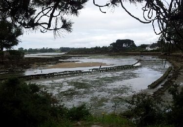
Randonnée Marche de 23 km à découvrir à Bretagne, Morbihan, Belz. Cette randonnée est proposée par chessyca.
Description
Quatrième journée du séjour
Départ en bus de Penthièvre à Pont Lorois
Arrivée à Lorient et bus jusqu'à l'auberge de Jeunesse
Pas de difficultés sur le terrain
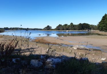
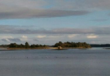
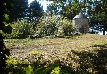
de splendides paysages
Localisation
Pays :
France
Région :
Bretagne
Département/Province :
Morbihan
Commune :
Belz
Localité :
Unknown
Départ:(Dec)
Départ:(UTM)
485178 ; 5280299 (30T) N.
Commentaires
Randonnées à proximité
![Randonnée Marche nordique Plouhinec - D'Etel au Pont Laurois par les deux côtés de la Ria - Photo](https://media.geolcdn.com/t/375/260/ext.jpg?maxdim=2&url=https%3A%2F%2Fservices.sitytrail.com%2FGeolivesWS%2FDownloadMedia.ashx%3FTrailID%3D323717%26Media%3Dfix__20140713124707.jpg)
![Marche nordique Marche nordique](https://static1.geolcdn.com/sitytour/trail-icons/102.png)
D'Etel au Pont Laurois par les deux côtés de la Ria
Marche nordique
Facile
(2)
Plouhinec,
Bretagne,
Morbihan,
France
![](/images/other/stat-length.png)
13,3 km | 14,5 km-effort
2h 25min
![](https://static1.geolcdn.com/siteimages/upload/files/16400158638029165_repeat_loop_refresh_sync_direction_icon.png)
Non
![Randonnée Marche Plouhinec - PR_56_Plouhinec_AA_01_Circuit1b_La-Ria-Par-Les-Pinedes_20200712 - Photo](https://media.geolcdn.com/t/375/260/1d672734-99d3-43b8-9472-2acec23bab09.jpg&format=jpg&maxdim=2)
![Marche Marche](https://static1.geolcdn.com/sitytour/trail-icons/101.png)
PR_56_Plouhinec_AA_01_Circuit1b_La-Ria-Par-Les-Pinedes_20200712
Marche
Très facile
(2)
Plouhinec,
Bretagne,
Morbihan,
France
![](/images/other/stat-length.png)
9,7 km | 10,6 km-effort
2h 14min
![](https://static1.geolcdn.com/siteimages/upload/files/16400158638029165_repeat_loop_refresh_sync_direction_icon.png)
Oui
![Randonnée Marche Plouhinec - Rivière d'Etel - Photo](https://media.geolcdn.com/t/375/260/ext.jpg?maxdim=2&url=https%3A%2F%2Fservices.sitytrail.com%2FGeolivesWS%2FDownloadMedia.ashx%3FTrailID%3D691090%26Media%3Dfix__20170128155839.jpg)
![Marche Marche](https://static1.geolcdn.com/sitytour/trail-icons/101.png)
Rivière d'Etel
Marche
Moyen
(1)
Plouhinec,
Bretagne,
Morbihan,
France
![](/images/other/stat-length.png)
15,4 km | 16,7 km-effort
3h 42min
![](https://static1.geolcdn.com/siteimages/upload/files/16400158638029165_repeat_loop_refresh_sync_direction_icon.png)
Oui
![Randonnée Marche Étel - bignac - Photo](https://media.geolcdn.com/t/375/260/ext.jpg?maxdim=2&url=https%3A%2F%2Fservices.sitytrail.com%2FGeolivesWS%2FDownloadMedia.ashx%3FTrailID%3D153357%26Media%3D20120913152815.jpeg)
![Marche Marche](https://static1.geolcdn.com/sitytour/trail-icons/101.png)
![Randonnée Marche nordique Belz - Bignac 05-11-17 . - Photo](https://media.geolcdn.com/t/375/260/ext.jpg?maxdim=2&url=https%3A%2F%2Fservices.sitytrail.com%2FGeolivesWS%2FDownloadMedia.ashx%3FTrailID%3D857287%26Media%3Dfix__20171104144738.jpg)
![Marche nordique Marche nordique](https://static1.geolcdn.com/sitytour/trail-icons/102.png)
Bignac 05-11-17 .
Marche nordique
Très facile
(1)
Belz,
Bretagne,
Morbihan,
France
![](/images/other/stat-length.png)
9,8 km | 10,7 km-effort
1h 53min
![](https://static1.geolcdn.com/siteimages/upload/files/16400158638029165_repeat_loop_refresh_sync_direction_icon.png)
Oui
![Randonnée Marche Belz - L 'Île de Saint Cado (07- 06-15 - Photo](https://media.geolcdn.com/t/375/260/ext.jpg?maxdim=2&url=https%3A%2F%2Fservices.sitytrail.com%2FGeolivesWS%2FDownloadMedia.ashx%3FTrailID%3D430884%26Media%3Dfix__20150607180503.jpg)
![Marche Marche](https://static1.geolcdn.com/sitytour/trail-icons/101.png)
L 'Île de Saint Cado (07- 06-15
Marche
Très facile
(1)
Belz,
Bretagne,
Morbihan,
France
![](/images/other/stat-length.png)
2,2 km | 2,4 km-effort
55min
![](https://static1.geolcdn.com/siteimages/upload/files/16400158638029165_repeat_loop_refresh_sync_direction_icon.png)
Oui
![Randonnée Autre activité Étel - D'Etel au Narbon - Photo](https://media.geolcdn.com/t/375/260/ext.jpg?maxdim=2&url=https%3A%2F%2Fstatic1.geolcdn.com%2Fsiteimages%2Fupload%2Ffiles%2F1545311037marcheuse_200dpi.jpg)
![Autre activité Autre activité](https://static1.geolcdn.com/sitytour/trail-icons/900.png)
D'Etel au Narbon
Autre activité
Très facile
(1)
Étel,
Bretagne,
Morbihan,
France
![](/images/other/stat-length.png)
8,2 km | 8,8 km-effort
1h 30min
![](https://static1.geolcdn.com/siteimages/upload/files/16400158638029165_repeat_loop_refresh_sync_direction_icon.png)
Non
![Randonnée Marche Plouhinec - tour ria etel bretagne - Photo](https://media.geolcdn.com/t/375/260/ext.jpg?maxdim=2&url=https%3A%2F%2Fservices.sitytrail.com%2FGeolivesWS%2FDownloadMedia.ashx%3FTrailID%3D329248%26Media%3Dfix__20140730144510.jpg)
![Marche Marche](https://static1.geolcdn.com/sitytour/trail-icons/101.png)
tour ria etel bretagne
Marche
Facile
(1)
Plouhinec,
Bretagne,
Morbihan,
France
![](/images/other/stat-length.png)
15,3 km | 16,8 km-effort
3h 57min
![](https://static1.geolcdn.com/siteimages/upload/files/16400158638029165_repeat_loop_refresh_sync_direction_icon.png)
Oui
![Randonnée A pied Belz - Etre douar ar mor - Photo](https://media.geolcdn.com/t/375/260/e888e374-1c52-424c-bf66-49a872f27ec5.jpeg&format=jpg&maxdim=2)
![A pied A pied](https://static1.geolcdn.com/sitytour/trail-icons/100.png)