![](/images/other/stat-length.png)
![Randonnée Marche Arfons - Arfons - Tarn : les terres des Hospitaliers de St.Jean - - Photo](https://media.geolcdn.com/t/1900/400/ext.pjpeg?maxdim=2&url=https%3A%2F%2Fmedia.geolcdn.com%2Ff%2F84238550-4498-4442-af25-802a7af20f15.jpg)
Arfons - Tarn : les terres des Hospitaliers de St.Jean -
chrisgps
Utilisateur
![Longueur](/images/other/stat-length.png)
Longueur
16,6 km
![Altitude max](https://static1.geolcdn.com/siteimages/upload/files/1508320355ic_sort_altitude_max_24dp.png)
Altitude max
819 m
![Dénivelé positif](https://static1.geolcdn.com/siteimages/upload/files/1508320355ic_sort_den_pos_24dp.png)
Dénivelé positif
283 m
![Km-Effort](/images/other/stat-length.png)
Km-Effort
20 km
![Altitude min](https://static1.geolcdn.com/siteimages/upload/files/1508320355ic_sort_altitude_min_24dp.png)
Altitude min
637 m
![Dénivelé négatif](https://static1.geolcdn.com/siteimages/upload/files/1508320355ic_sort_den_neg_24dp.png)
Dénivelé négatif
282 m
![Boucle](https://static1.geolcdn.com/siteimages/upload/files/16400158638029165_repeat_loop_refresh_sync_direction_icon.png)
Boucle
Oui
Date de création :
2024-05-29 07:16:36.394
Dernière modification :
2024-06-08 16:59:28.088
![Marche](https://static1.geolcdn.com/sitytour/trail-icons/101.png)
5h33
Difficulté : Très facile
![Scannez ce code QR pour ouvrir la randonnée dans l'application SityTrail](https://capi.geolives.com/qq0zvz2zws4bq2lad0pu/sitytour/trails/4072349/qr.png?size=200)
Application GPS de randonnée GRATUITE
À propos
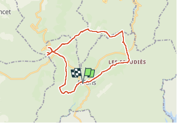
Randonnée Marche de 16,6 km à découvrir à Occitanie, Tarn, Arfons. Cette randonnée est proposée par chrisgps.
Description
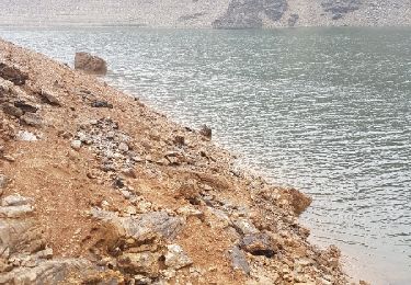
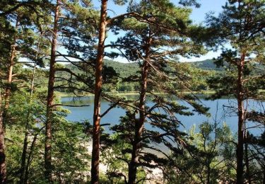
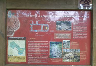
Beau circuit en foret principalement.
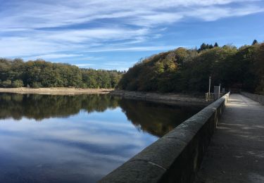
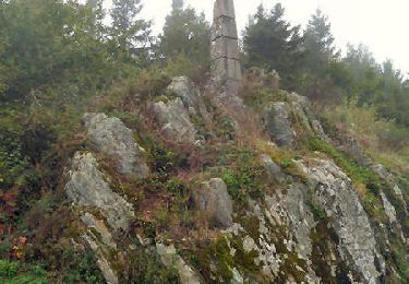
La vue depuis la table d'orientation est grandiose. Les vallonnements et collines bordés d'arbres et des genêts et ajoncs renforcent la beauté des paysages.
Localisation
Pays :
France
Région :
Occitanie
Département/Province :
Tarn
Commune :
Arfons
Localité :
Unknown
Départ:(Dec)
Départ:(UTM)
432532 ; 4808872 (31T) N.
Commentaires
Randonnées à proximité
![Randonnée Marche Arfons - ramondens100320 ex - Photo](https://media.geolcdn.com/t/375/260/ext.jpg?maxdim=2&url=https%3A%2F%2Fmedia.geolcdn.com%2Ff%2F99a4d0ee-81ce-4d97-8c95-1e256b55dc29.jpg)
![Marche Marche](https://static1.geolcdn.com/sitytour/trail-icons/101.png)
ramondens100320 ex
Marche
Très facile
Arfons,
Occitanie,
Tarn,
France
![](/images/other/stat-length.png)
5,8 km | 8 km-effort
1h 26min
![](https://static1.geolcdn.com/siteimages/upload/files/16400158638029165_repeat_loop_refresh_sync_direction_icon.png)
Oui
![Randonnée Marche Saissac - Cammazes Lampy fait. - Photo](https://media.geolcdn.com/t/375/260/ext.jpg?maxdim=2&url=https%3A%2F%2Fstatic1.geolcdn.com%2Fsiteimages%2Fupload%2Ffiles%2F1553511878bg_sport_marche.png)
![Marche Marche](https://static1.geolcdn.com/sitytour/trail-icons/101.png)
Cammazes Lampy fait.
Marche
Facile
(1)
Saissac,
Occitanie,
Aude,
France
![](/images/other/stat-length.png)
14,8 km | 17,3 km-effort
4h 36min
![](https://static1.geolcdn.com/siteimages/upload/files/16400158638029165_repeat_loop_refresh_sync_direction_icon.png)
Oui
![Randonnée V.T.T. Dourgne - La Croix des fangasse , les Escudiers , arfons - Photo](https://media.geolcdn.com/t/375/260/ext.jpg?maxdim=2&url=https%3A%2F%2Fmedia.geolcdn.com%2Ff%2Fb5865fd3-1995-49c4-aeee-4b6bc0b98554.jpg)
![V.T.T. V.T.T.](https://static1.geolcdn.com/sitytour/trail-icons/202.png)
La Croix des fangasse , les Escudiers , arfons
V.T.T.
Moyen
Dourgne,
Occitanie,
Tarn,
France
![](/images/other/stat-length.png)
23 km | 0 m-effort
3h 24min
![](https://static1.geolcdn.com/siteimages/upload/files/16400158638029165_repeat_loop_refresh_sync_direction_icon.png)
Oui
![Randonnée Autre activité Les Cammazes - pêche au cammazes broc - Photo](https://media.geolcdn.com/t/375/260/ext.jpg?maxdim=2&url=https%3A%2F%2Fservices.sitytrail.com%2FGeolivesWS%2FDownloadMedia.ashx%3FTrailID%3D923135%26Media%3Dfix__20171111104013.jpg)
![Autre activité Autre activité](https://static1.geolcdn.com/sitytour/trail-icons/900.png)
pêche au cammazes broc
Autre activité
Très facile
(1)
Les Cammazes,
Occitanie,
Tarn,
France
![](/images/other/stat-length.png)
2,2 km | 2,7 km-effort
2h 56min
![](https://static1.geolcdn.com/siteimages/upload/files/16400158638029165_repeat_loop_refresh_sync_direction_icon.png)
Non
![Randonnée Marche Saissac - Le LAMPY - Photo](https://media.geolcdn.com/t/375/260/ext.jpg?maxdim=2&url=https%3A%2F%2Fstatic1.geolcdn.com%2Fsiteimages%2Fupload%2Ffiles%2F1553511878bg_sport_marche.png)
![Marche Marche](https://static1.geolcdn.com/sitytour/trail-icons/101.png)
![Randonnée V.T.T. Arfons - D'Arfons au Lac de Saint Ferréol - Photo](https://media.geolcdn.com/t/375/260/ext.jpg?maxdim=2&url=https%3A%2F%2Fservices.sitytrail.com%2FGeolivesWS%2FDownloadMedia.ashx%3FTrailID%3D172847%26Media%3D14291_6.jpg)
![V.T.T. V.T.T.](https://static1.geolcdn.com/sitytour/trail-icons/202.png)
D'Arfons au Lac de Saint Ferréol
V.T.T.
Difficile
Arfons,
Occitanie,
Tarn,
France
![](/images/other/stat-length.png)
29 km | 39 km-effort
3h 19min
![](https://static1.geolcdn.com/siteimages/upload/files/16400158638029165_repeat_loop_refresh_sync_direction_icon.png)
Non
![Randonnée Marche Arfons - Les terres des hospitaliers de Jérusalem - Arfons - Photo](https://media.geolcdn.com/t/375/260/ext.jpg?maxdim=2&url=https%3A%2F%2Fservices.sitytrail.com%2FGeolivesWS%2FDownloadMedia.ashx%3FTrailID%3D172844%26Media%3D14286_5.jpg)
![Marche Marche](https://static1.geolcdn.com/sitytour/trail-icons/101.png)
Les terres des hospitaliers de Jérusalem - Arfons
Marche
Moyen
(1)
Arfons,
Occitanie,
Tarn,
France
![](/images/other/stat-length.png)
22 km | 27 km-effort
6h 30min
![](https://static1.geolcdn.com/siteimages/upload/files/16400158638029165_repeat_loop_refresh_sync_direction_icon.png)
Oui
![Randonnée Marche Arfons - mardi19mars - Photo](https://media.geolcdn.com/t/375/260/ext.jpg?maxdim=2&url=https%3A%2F%2Fmedia.geolcdn.com%2Ff%2Ff659fd7d-9d41-43ec-ada4-64d14a260b2d.jpg)
![Marche Marche](https://static1.geolcdn.com/sitytour/trail-icons/101.png)
mardi19mars
Marche
Très difficile
Arfons,
Occitanie,
Tarn,
France
![](/images/other/stat-length.png)
593 km | 866 km-effort
8h 20min
![](https://static1.geolcdn.com/siteimages/upload/files/16400158638029165_repeat_loop_refresh_sync_direction_icon.png)
Non
![Randonnée Marche Arfons - Arfons granges vieilles et croix de Montalric - Photo](https://media.geolcdn.com/t/375/260/ext.jpg?maxdim=2&url=https%3A%2F%2Fmedia.geolcdn.com%2Ff%2F2a456a14-a361-40da-a6f3-231fe5e69d9d.jpg)
![Marche Marche](https://static1.geolcdn.com/sitytour/trail-icons/101.png)
Arfons granges vieilles et croix de Montalric
Marche
Facile
Arfons,
Occitanie,
Tarn,
France
![](/images/other/stat-length.png)
9,2 km | 11,8 km-effort
3h 26min
![](https://static1.geolcdn.com/siteimages/upload/files/16400158638029165_repeat_loop_refresh_sync_direction_icon.png)
Oui