![](/images/other/stat-length.png)
![Randonnée Marche Seninghem - boucle de 13.6km au départ de SENINGHEM ( Lumbres ) 230 déniv - Photo](https://media.geolcdn.com/t/1900/400/ext.pjpeg?maxdim=2&url=https%3A%2F%2Fstatic1.geolcdn.com%2Fsiteimages%2Fupload%2Ffiles%2F1553511878bg_sport_marche.png)
boucle de 13.6km au départ de SENINGHEM ( Lumbres ) 230 déniv
eaea7charles
Utilisateur
![Longueur](/images/other/stat-length.png)
Longueur
13,6 km
![Altitude max](https://static1.geolcdn.com/siteimages/upload/files/1508320355ic_sort_altitude_max_24dp.png)
Altitude max
203 m
![Dénivelé positif](https://static1.geolcdn.com/siteimages/upload/files/1508320355ic_sort_den_pos_24dp.png)
Dénivelé positif
230 m
![Km-Effort](/images/other/stat-length.png)
Km-Effort
16,7 km
![Altitude min](https://static1.geolcdn.com/siteimages/upload/files/1508320355ic_sort_altitude_min_24dp.png)
Altitude min
79 m
![Dénivelé négatif](https://static1.geolcdn.com/siteimages/upload/files/1508320355ic_sort_den_neg_24dp.png)
Dénivelé négatif
232 m
![Boucle](https://static1.geolcdn.com/siteimages/upload/files/16400158638029165_repeat_loop_refresh_sync_direction_icon.png)
Boucle
Oui
Date de création :
2024-05-25 07:14:23.77
Dernière modification :
2024-05-25 07:19:27.56
![Marche](https://static1.geolcdn.com/sitytour/trail-icons/101.png)
3h47
Difficulté : Difficile
![Scannez ce code QR pour ouvrir la randonnée dans l'application SityTrail](https://capi.geolives.com/qq0zvz2zws4bq2lad0pu/sitytour/trails/4067039/qr.png?size=200)
Application GPS de randonnée GRATUITE
À propos
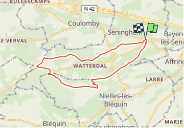
Randonnée Marche de 13,6 km à découvrir à Hauts-de-France, Pas-de-Calais, Seninghem. Cette randonnée est proposée par eaea7charles.
Description
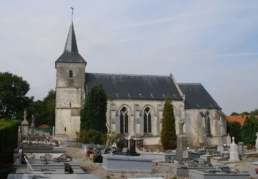
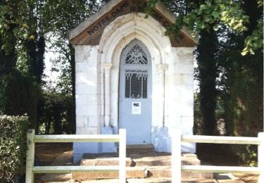
départ de la chapelle Notre dame des ardents ( le feu des ardents due à l'ergot du seigle ) ; passage à la chapelle Notre dame du Mont
Localisation
Pays :
France
Région :
Hauts-de-France
Département/Province :
Pas-de-Calais
Commune :
Seninghem
Localité :
Unknown
Départ:(Dec)
Départ:(UTM)
432944 ; 5616783 (31U) N.
Commentaires
Randonnées à proximité
![Randonnée Marche Nielles-lès-Bléquin - Le mont de Drionville - Nielles-lès-Bléquin - Photo](https://media.geolcdn.com/t/375/260/ext.jpg?maxdim=2&url=https%3A%2F%2Fservices.sitytrail.com%2FGeolivesWS%2FDownloadMedia.ashx%3FTrailID%3D112109%26Media%3D9905_3.jpg)
![Marche Marche](https://static1.geolcdn.com/sitytour/trail-icons/101.png)
Le mont de Drionville - Nielles-lès-Bléquin
Marche
Moyen
(2)
Nielles-lès-Bléquin,
Hauts-de-France,
Pas-de-Calais,
France
![](/images/other/stat-length.png)
9,1 km | 11 km-effort
2h 15min
![](https://static1.geolcdn.com/siteimages/upload/files/16400158638029165_repeat_loop_refresh_sync_direction_icon.png)
Oui
![Randonnée V.T.T. Lumbres - Les Grands Camps - Lumbres - Photo](https://media.geolcdn.com/t/375/260/ext.jpg?maxdim=2&url=https%3A%2F%2Fservices.sitytrail.com%2FGeolivesWS%2FDownloadMedia.ashx%3FTrailID%3D112093%26Media%3D9873_6.jpg)
![V.T.T. V.T.T.](https://static1.geolcdn.com/sitytour/trail-icons/202.png)
Les Grands Camps - Lumbres
V.T.T.
Difficile
Lumbres,
Hauts-de-France,
Pas-de-Calais,
France
![](/images/other/stat-length.png)
24 km | 30 km-effort
3h 0min
![](https://static1.geolcdn.com/siteimages/upload/files/16400158638029165_repeat_loop_refresh_sync_direction_icon.png)
Oui
![Randonnée Marche Bouvelinghem - Les quatre bois - Photo](https://media.geolcdn.com/t/375/260/ext.jpg?maxdim=2&url=https%3A%2F%2Fmedia.geolcdn.com%2Ff%2Faa1d5156-b2f9-4aef-95a3-34a50bb149d4.jpg)
![Marche Marche](https://static1.geolcdn.com/sitytour/trail-icons/101.png)
Les quatre bois
Marche
Moyen
Bouvelinghem,
Hauts-de-France,
Pas-de-Calais,
France
![](/images/other/stat-length.png)
11,6 km | 14,7 km-effort
3h 5min
![](https://static1.geolcdn.com/siteimages/upload/files/16400158638029165_repeat_loop_refresh_sync_direction_icon.png)
Oui
![Randonnée Marche Alquines - Le Mont Vert - Alquines - Photo](https://media.geolcdn.com/t/375/260/ext.jpg?maxdim=2&url=https%3A%2F%2Fservices.sitytrail.com%2FGeolivesWS%2FDownloadMedia.ashx%3FTrailID%3D112226%26Media%3D10114_1.jpg)
![Marche Marche](https://static1.geolcdn.com/sitytour/trail-icons/101.png)
Le Mont Vert - Alquines
Marche
Difficile
Alquines,
Hauts-de-France,
Pas-de-Calais,
France
![](/images/other/stat-length.png)
12,6 km | 15,8 km-effort
3h 10min
![](https://static1.geolcdn.com/siteimages/upload/files/16400158638029165_repeat_loop_refresh_sync_direction_icon.png)
Oui
![Randonnée V.T.T. Acquin-Westbécourt - 2011-10-16 - 11h33m49 - Photo](https://media.geolcdn.com/t/375/260/ext.jpg?maxdim=2&url=https%3A%2F%2Fservices.sitytrail.com%2FGeolivesWS%2FDownloadMedia.ashx%3FTrailID%3D86860%26Media%3D20111016111641.jpg)
![V.T.T. V.T.T.](https://static1.geolcdn.com/sitytour/trail-icons/202.png)
2011-10-16 - 11h33m49
V.T.T.
Très facile
Acquin-Westbécourt,
Hauts-de-France,
Pas-de-Calais,
France
![](/images/other/stat-length.png)
22 km | 26 km-effort
2h 15min
![](https://static1.geolcdn.com/siteimages/upload/files/16400158638029165_repeat_loop_refresh_sync_direction_icon.png)
Oui
![Randonnée Marche Nielles-lès-Bléquin - nielles watterdal les chapelles - Photo](https://media.geolcdn.com/t/375/260/ext.jpg?maxdim=2&url=https%3A%2F%2Fstatic1.geolcdn.com%2Fsiteimages%2Fupload%2Ffiles%2F1553511878bg_sport_marche.png)
![Marche Marche](https://static1.geolcdn.com/sitytour/trail-icons/101.png)
nielles watterdal les chapelles
Marche
Difficile
Nielles-lès-Bléquin,
Hauts-de-France,
Pas-de-Calais,
France
![](/images/other/stat-length.png)
11,8 km | 14,5 km-effort
3h 17min
![](https://static1.geolcdn.com/siteimages/upload/files/16400158638029165_repeat_loop_refresh_sync_direction_icon.png)
Oui
![Randonnée Marche Acquin-Westbécourt - val d'Avquin - Photo](https://media.geolcdn.com/t/375/260/ext.jpg?maxdim=2&url=https%3A%2F%2Fmedia.geolcdn.com%2Ff%2Fe35ef070-ab1a-4b04-849a-32e998408523.jpg)
![Marche Marche](https://static1.geolcdn.com/sitytour/trail-icons/101.png)
val d'Avquin
Marche
Moyen
Acquin-Westbécourt,
Hauts-de-France,
Pas-de-Calais,
France
![](/images/other/stat-length.png)
9,5 km | 11,6 km-effort
2h 27min
![](https://static1.geolcdn.com/siteimages/upload/files/16400158638029165_repeat_loop_refresh_sync_direction_icon.png)
Oui
![Randonnée Marche Acquin-Westbécourt - Acquin - Le Noovre - Photo](https://media.geolcdn.com/t/375/260/ext.jpg?maxdim=2&url=https%3A%2F%2Fstatic1.geolcdn.com%2Fsiteimages%2Fupload%2Ffiles%2F1553511878bg_sport_marche.png)
![Marche Marche](https://static1.geolcdn.com/sitytour/trail-icons/101.png)
Acquin - Le Noovre
Marche
Très facile
Acquin-Westbécourt,
Hauts-de-France,
Pas-de-Calais,
France
![](/images/other/stat-length.png)
9,5 km | 11,5 km-effort
2h 30min
![](https://static1.geolcdn.com/siteimages/upload/files/16400158638029165_repeat_loop_refresh_sync_direction_icon.png)
Oui
![Randonnée Marche Nielles-lès-Bléquin - Nielles-lès-Bléquin 11.8Km Dén P 185m - Photo](https://media.geolcdn.com/t/375/260/ext.jpg?maxdim=2&url=https%3A%2F%2Fstatic1.geolcdn.com%2Fsiteimages%2Fupload%2Ffiles%2F1553511878bg_sport_marche.png)
![Marche Marche](https://static1.geolcdn.com/sitytour/trail-icons/101.png)
Nielles-lès-Bléquin 11.8Km Dén P 185m
Marche
Moyen
Nielles-lès-Bléquin,
Hauts-de-France,
Pas-de-Calais,
France
![](/images/other/stat-length.png)
11,8 km | 14,3 km-effort
2h 16min
![](https://static1.geolcdn.com/siteimages/upload/files/16400158638029165_repeat_loop_refresh_sync_direction_icon.png)
Oui