![](/images/other/stat-length.png)
![Randonnée Marche Fontaine-les-Coteaux - Fontaine-les-Coteaux - Bois de Beauvoir - Photo](https://media.geolcdn.com/t/1900/400/f4df1028-c791-4d9e-a4ba-018405d7c959.jpg&format=pjpeg&maxdim=2)
Fontaine-les-Coteaux - Bois de Beauvoir
guydu41
Utilisateur
![Longueur](/images/other/stat-length.png)
Longueur
9,1 km
![Altitude max](https://static1.geolcdn.com/siteimages/upload/files/1508320355ic_sort_altitude_max_24dp.png)
Altitude max
141 m
![Dénivelé positif](https://static1.geolcdn.com/siteimages/upload/files/1508320355ic_sort_den_pos_24dp.png)
Dénivelé positif
171 m
![Km-Effort](/images/other/stat-length.png)
Km-Effort
11,4 km
![Altitude min](https://static1.geolcdn.com/siteimages/upload/files/1508320355ic_sort_altitude_min_24dp.png)
Altitude min
80 m
![Dénivelé négatif](https://static1.geolcdn.com/siteimages/upload/files/1508320355ic_sort_den_neg_24dp.png)
Dénivelé négatif
171 m
![Boucle](https://static1.geolcdn.com/siteimages/upload/files/16400158638029165_repeat_loop_refresh_sync_direction_icon.png)
Boucle
Oui
Date de création :
2024-05-19 11:16:45.126
Dernière modification :
2024-05-19 15:54:55.404
![Marche](https://static1.geolcdn.com/sitytour/trail-icons/101.png)
2h14
Difficulté : Facile
![Scannez ce code QR pour ouvrir la randonnée dans l'application SityTrail](https://capi.geolives.com/qq0zvz2zws4bq2lad0pu/sitytour/trails/4060029/qr.png?size=200)
Application GPS de randonnée GRATUITE
À propos
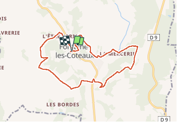
Randonnée Marche de 9,1 km à découvrir à Centre-Val de Loire, Loir-et-Cher, Fontaine-les-Coteaux. Cette randonnée est proposée par guydu41.
Description
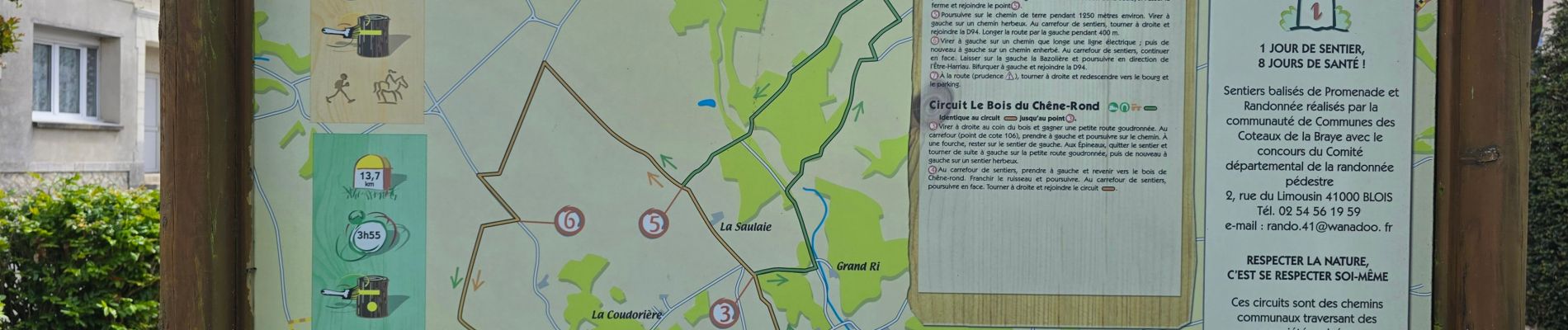
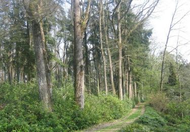
Ce circuit sur des chemins et sentiers communaux est agréable surtout dans les bois.
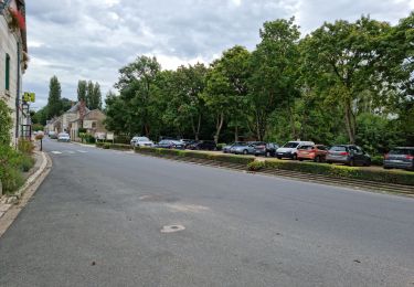
Départ depuis le parking à côté de l'église Saint-Pierre de Fontaine-les-Coteaux.
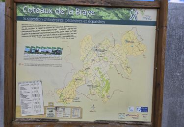
Il existe deux autres circuits PR balisés jaune.
Localisation
Pays :
France
Région :
Centre-Val de Loire
Département/Province :
Loir-et-Cher
Commune :
Fontaine-les-Coteaux
Localité :
Unknown
Départ:(Dec)
Départ:(UTM)
337320 ; 5296220 (31T) N.
Commentaires
Randonnées à proximité
![Randonnée Marche Fontaine-les-Coteaux - Fontaine-les-coteaux - Bois de Beauvoir - Photo](https://media.geolcdn.com/t/375/260/03eb29ee-58eb-4007-b788-88126facd998.jpg&format=jpg&maxdim=2)
![Marche Marche](https://static1.geolcdn.com/sitytour/trail-icons/101.png)
Fontaine-les-coteaux - Bois de Beauvoir
Marche
Moyen
Fontaine-les-Coteaux,
Centre-Val de Loire,
Loir-et-Cher,
France
![](/images/other/stat-length.png)
11,7 km | 14,8 km-effort
3h 22min
![](https://static1.geolcdn.com/siteimages/upload/files/16400158638029165_repeat_loop_refresh_sync_direction_icon.png)
Oui
![Randonnée Marche Les Roches-l'Évêque - Les Roches-l'Evêque - Photo](https://media.geolcdn.com/t/375/260/dca20853-d794-4c8a-9c81-2319f41b2890.jpg&format=jpg&maxdim=2)
![Marche Marche](https://static1.geolcdn.com/sitytour/trail-icons/101.png)
Les Roches-l'Evêque
Marche
Moyen
Les Roches-l'Évêque,
Centre-Val de Loire,
Loir-et-Cher,
France
![](/images/other/stat-length.png)
8,8 km | 11,1 km-effort
2h 31min
![](https://static1.geolcdn.com/siteimages/upload/files/16400158638029165_repeat_loop_refresh_sync_direction_icon.png)
Oui
![Randonnée V.T.T. Fontaine-les-Coteaux - VTT autour de Fontaine-les-Coteaux - Photo](https://media.geolcdn.com/t/375/260/ext.jpg?maxdim=2&url=https%3A%2F%2Fservices.sitytrail.com%2FGeolivesWS%2FDownloadMedia.ashx%3FTrailID%3D172891%26Media%3D14350_5.jpg)
![V.T.T. V.T.T.](https://static1.geolcdn.com/sitytour/trail-icons/202.png)
VTT autour de Fontaine-les-Coteaux
V.T.T.
Difficile
Fontaine-les-Coteaux,
Centre-Val de Loire,
Loir-et-Cher,
France
![](/images/other/stat-length.png)
50 km | 59 km-effort
3h 0min
![](https://static1.geolcdn.com/siteimages/upload/files/16400158638029165_repeat_loop_refresh_sync_direction_icon.png)
Oui
![Randonnée Marche Trôo - Trôo - Sougé - GR35 AR - 20.5km 340m 4h30 (25mn) - 2018 05 20 - Photo](https://media.geolcdn.com/t/375/260/ext.jpg?maxdim=2&url=https%3A%2F%2Fstatic1.geolcdn.com%2Fsiteimages%2Fupload%2Ffiles%2F1553511878bg_sport_marche.png)
![Marche Marche](https://static1.geolcdn.com/sitytour/trail-icons/101.png)
Trôo - Sougé - GR35 AR - 20.5km 340m 4h30 (25mn) - 2018 05 20
Marche
Moyen
Trôo,
Centre-Val de Loire,
Loir-et-Cher,
France
![](/images/other/stat-length.png)
20 km | 25 km-effort
4h 30min
![](https://static1.geolcdn.com/siteimages/upload/files/16400158638029165_repeat_loop_refresh_sync_direction_icon.png)
Oui
![Randonnée Marche Trôo - Trôo - 12.4km 260m 3h20 (30mn) - 2017 05 28 - Photo](https://media.geolcdn.com/t/375/260/ext.jpg?maxdim=2&url=https%3A%2F%2Fstatic1.geolcdn.com%2Fsiteimages%2Fupload%2Ffiles%2F1553511878bg_sport_marche.png)
![Marche Marche](https://static1.geolcdn.com/sitytour/trail-icons/101.png)
Trôo - 12.4km 260m 3h20 (30mn) - 2017 05 28
Marche
Moyen
Trôo,
Centre-Val de Loire,
Loir-et-Cher,
France
![](/images/other/stat-length.png)
12,4 km | 15,8 km-effort
3h 20min
![](https://static1.geolcdn.com/siteimages/upload/files/16400158638029165_repeat_loop_refresh_sync_direction_icon.png)
Oui
![Randonnée Marche Trôo - Sentier des troglodytes à Trôo - Photo](https://media.geolcdn.com/t/375/260/3c5c649d-692b-4680-8b9c-2f6808188217.jpg&format=jpg&maxdim=2)
![Marche Marche](https://static1.geolcdn.com/sitytour/trail-icons/101.png)
Sentier des troglodytes à Trôo
Marche
Difficile
Trôo,
Centre-Val de Loire,
Loir-et-Cher,
France
![](/images/other/stat-length.png)
2,6 km | 3,6 km-effort
1h 5min
![](https://static1.geolcdn.com/siteimages/upload/files/16400158638029165_repeat_loop_refresh_sync_direction_icon.png)
Oui
![Randonnée A pied Trôo - troo - Photo](https://media.geolcdn.com/t/375/260/ext.jpg?maxdim=2&url=https%3A%2F%2Fstatic1.geolcdn.com%2Fsiteimages%2Fupload%2Ffiles%2F1545311037marcheuse_200dpi.jpg)
![A pied A pied](https://static1.geolcdn.com/sitytour/trail-icons/100.png)
troo
A pied
Très facile
Trôo,
Centre-Val de Loire,
Loir-et-Cher,
France
![](/images/other/stat-length.png)
16 km | 19 km-effort
Inconnu
![](https://static1.geolcdn.com/siteimages/upload/files/16400158638029165_repeat_loop_refresh_sync_direction_icon.png)
Oui
![Randonnée Marche Montoire-sur-le-Loir - Montoire 1.10.2023 - Photo](https://media.geolcdn.com/t/375/260/ext.jpg?maxdim=2&url=https%3A%2F%2Fstatic1.geolcdn.com%2Fsiteimages%2Fupload%2Ffiles%2F1553511878bg_sport_marche.png)
![Marche Marche](https://static1.geolcdn.com/sitytour/trail-icons/101.png)
Montoire 1.10.2023
Marche
Moyen
Montoire-sur-le-Loir,
Centre-Val de Loire,
Loir-et-Cher,
France
![](/images/other/stat-length.png)
34 km | 40 km-effort
5h 28min
![](https://static1.geolcdn.com/siteimages/upload/files/16400158638029165_repeat_loop_refresh_sync_direction_icon.png)
Oui
![Randonnée Marche Trôo - Trôo 23-05-2022 - Photo](https://media.geolcdn.com/t/375/260/ext.jpg?maxdim=2&url=https%3A%2F%2Fstatic1.geolcdn.com%2Fsiteimages%2Fupload%2Ffiles%2F1553511878bg_sport_marche.png)
![Marche Marche](https://static1.geolcdn.com/sitytour/trail-icons/101.png)
Trôo 23-05-2022
Marche
Facile
(1)
Trôo,
Centre-Val de Loire,
Loir-et-Cher,
France
![](/images/other/stat-length.png)
6,4 km | 8,4 km-effort
1h 53min
![](https://static1.geolcdn.com/siteimages/upload/files/16400158638029165_repeat_loop_refresh_sync_direction_icon.png)
Oui