![](/images/other/stat-length.png)
![Randonnée Marche nordique Claracq - CLARAC LALONQUETTE LANUSSE - Photo](https://media.geolcdn.com/t/1900/400/ext.pjpeg?maxdim=2&url=https%3A%2F%2Fmedia.geolcdn.com%2Ff%2F0dce10b4-8813-484e-8a70-c4ccf1ad06e7.jpg)
CLARAC LALONQUETTE LANUSSE
marmotte65
Utilisateur GUIDE
![Longueur](/images/other/stat-length.png)
Longueur
7,7 km
![Altitude max](https://static1.geolcdn.com/siteimages/upload/files/1508320355ic_sort_altitude_max_24dp.png)
Altitude max
266 m
![Dénivelé positif](https://static1.geolcdn.com/siteimages/upload/files/1508320355ic_sort_den_pos_24dp.png)
Dénivelé positif
53 m
![Km-Effort](/images/other/stat-length.png)
Km-Effort
8,7 km
![Altitude min](https://static1.geolcdn.com/siteimages/upload/files/1508320355ic_sort_altitude_min_24dp.png)
Altitude min
152 m
![Dénivelé négatif](https://static1.geolcdn.com/siteimages/upload/files/1508320355ic_sort_den_neg_24dp.png)
Dénivelé négatif
131 m
![Boucle](https://static1.geolcdn.com/siteimages/upload/files/16400158638029165_repeat_loop_refresh_sync_direction_icon.png)
Boucle
Non
Date de création :
2024-05-17 09:59:37.872
Dernière modification :
2024-05-18 08:04:36.087
![Marche nordique](https://static1.geolcdn.com/sitytour/trail-icons/102.png)
2h18
Difficulté : Très facile
![Scannez ce code QR pour ouvrir la randonnée dans l'application SityTrail](https://capi.geolives.com/qq0zvz2zws4bq2lad0pu/sitytour/trails/4058325/qr.png?size=200)
Application GPS de randonnée GRATUITE
À propos
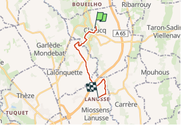
Randonnée Marche nordique de 7,7 km à découvrir à Nouvelle-Aquitaine, Pyrénées-Atlantiques, Claracq. Cette randonnée est proposée par marmotte65.
Description
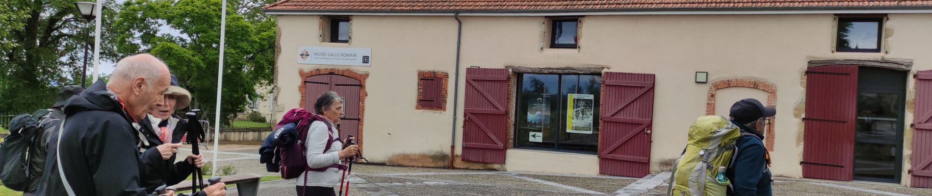
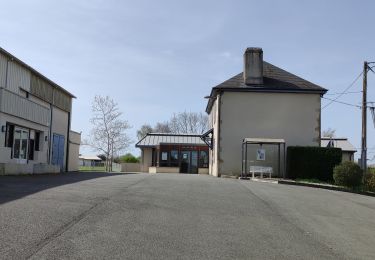
Belle balade instructive de part la visite du musée de la villa gallo-romaine et visite de la meme villa avant notre PN sur les tables prévues à cette effet. La fin de notre périple se fera a l'église de l'anussse
Localisation
Pays :
France
Région :
Nouvelle-Aquitaine
Département/Province :
Pyrénées-Atlantiques
Commune :
Claracq
Localité :
Unknown
Départ:(Dec)
Départ:(UTM)
718203 ; 4821108 (30T) N.
Commentaires
Randonnées à proximité
![Randonnée Marche Lalonquette - LALONQUETTE G4](https://media.geolcdn.com/t/375/260/ext.jpg?maxdim=2&url=https%3A%2F%2Fmedia.geolcdn.com%2Ff%2Fa48200d4-b143-45f4-9ba5-13cc7bac249e.jpg)
![Marche Marche](https://static1.geolcdn.com/sitytour/trail-icons/101.png)
LALONQUETTE G4 "3990562"
Marche
Moyen
Lalonquette,
Nouvelle-Aquitaine,
Pyrénées-Atlantiques,
France
![](/images/other/stat-length.png)
8,9 km | 10,2 km-effort
2h 8min
![](https://static1.geolcdn.com/siteimages/upload/files/16400158638029165_repeat_loop_refresh_sync_direction_icon.png)
Oui
![Randonnée A pied Claracq - CLARACQ villa-gallo-romaine _ Eglise de Lanusse](https://media.geolcdn.com/t/375/260/ext.jpg?maxdim=2&url=https%3A%2F%2Fstatic1.geolcdn.com%2Fsiteimages%2Fupload%2Ffiles%2F1545311037marcheuse_200dpi.jpg)
![A pied A pied](https://static1.geolcdn.com/sitytour/trail-icons/100.png)
CLARACQ villa-gallo-romaine _ Eglise de Lanusse "3990562"
A pied
Facile
Claracq,
Nouvelle-Aquitaine,
Pyrénées-Atlantiques,
France
![](/images/other/stat-length.png)
9,1 km | 10,9 km-effort
2h 29min
![](https://static1.geolcdn.com/siteimages/upload/files/16400158638029165_repeat_loop_refresh_sync_direction_icon.png)
Non
![Randonnée Marche Claracq - CLARACQ Villa gallo romaine](https://media.geolcdn.com/t/375/260/ext.jpg?maxdim=2&url=https%3A%2F%2Fmedia.geolcdn.com%2Ff%2Fcbd482a6-e29f-4da9-a4e4-1e1d5a6888a5.jpg)
![Marche Marche](https://static1.geolcdn.com/sitytour/trail-icons/101.png)
CLARACQ Villa gallo romaine "3979861"
Marche
Facile
Claracq,
Nouvelle-Aquitaine,
Pyrénées-Atlantiques,
France
![](/images/other/stat-length.png)
2,5 km | 2,9 km-effort
39min
![](https://static1.geolcdn.com/siteimages/upload/files/16400158638029165_repeat_loop_refresh_sync_direction_icon.png)
Non
![Randonnée Marche Lalonquette - fait Lalonquette - Photo](https://media.geolcdn.com/t/375/260/ext.jpg?maxdim=2&url=https%3A%2F%2Fstatic1.geolcdn.com%2Fsiteimages%2Fupload%2Ffiles%2F1553511878bg_sport_marche.png)
![Marche Marche](https://static1.geolcdn.com/sitytour/trail-icons/101.png)
fait Lalonquette
Marche
Moyen
Lalonquette,
Nouvelle-Aquitaine,
Pyrénées-Atlantiques,
France
![](/images/other/stat-length.png)
8,8 km | 10,1 km-effort
2h 53min
![](https://static1.geolcdn.com/siteimages/upload/files/16400158638029165_repeat_loop_refresh_sync_direction_icon.png)
Oui
![Randonnée Marche Garlin - garlin caprando - Photo](https://media.geolcdn.com/t/375/260/ext.jpg?maxdim=2&url=https%3A%2F%2Fstatic1.geolcdn.com%2Fsiteimages%2Fupload%2Ffiles%2F1553511878bg_sport_marche.png)
![Marche Marche](https://static1.geolcdn.com/sitytour/trail-icons/101.png)
garlin caprando
Marche
Très difficile
Garlin,
Nouvelle-Aquitaine,
Pyrénées-Atlantiques,
France
![](/images/other/stat-length.png)
19,5 km | 23 km-effort
4h 29min
![](https://static1.geolcdn.com/siteimages/upload/files/16400158638029165_repeat_loop_refresh_sync_direction_icon.png)
Non
![Randonnée Autre activité Boueilh-Boueilho-Lasque - 40 - Photo](https://media.geolcdn.com/t/375/260/ext.jpg?maxdim=2&url=https%3A%2F%2Fstatic1.geolcdn.com%2Fsiteimages%2Fupload%2Ffiles%2F1545311037marcheuse_200dpi.jpg)
![Autre activité Autre activité](https://static1.geolcdn.com/sitytour/trail-icons/900.png)
40
Autre activité
Très facile
Boueilh-Boueilho-Lasque,
Nouvelle-Aquitaine,
Pyrénées-Atlantiques,
France
![](/images/other/stat-length.png)
37 km | 42 km-effort
3h 15min
![](https://static1.geolcdn.com/siteimages/upload/files/16400158638029165_repeat_loop_refresh_sync_direction_icon.png)
Non
![Randonnée Marche Claracq - A - De Claracq à la villa Gallo-Romaine - Photo](https://media.geolcdn.com/t/375/260/ext.jpg?maxdim=2&url=https%3A%2F%2Fstatic1.geolcdn.com%2Fsiteimages%2Fupload%2Ffiles%2F1553511878bg_sport_marche.png)
![Marche Marche](https://static1.geolcdn.com/sitytour/trail-icons/101.png)
A - De Claracq à la villa Gallo-Romaine
Marche
Facile
Claracq,
Nouvelle-Aquitaine,
Pyrénées-Atlantiques,
France
![](/images/other/stat-length.png)
1,6 km | 2 km-effort
21min
![](https://static1.geolcdn.com/siteimages/upload/files/16400158638029165_repeat_loop_refresh_sync_direction_icon.png)
Non