![](/images/other/stat-length.png)
![Randonnée Marche Lignières - Lignières - Autour de Rocheux - Photo](https://media.geolcdn.com/t/1900/400/5a089ec4-d327-4054-a1b8-fd2e844efe76.jpg&format=pjpeg&maxdim=2)
Lignières - Autour de Rocheux
guydu41
Utilisateur
![Longueur](/images/other/stat-length.png)
![Altitude max](https://static1.geolcdn.com/siteimages/upload/files/1508320355ic_sort_altitude_max_24dp.png)
![Dénivelé positif](https://static1.geolcdn.com/siteimages/upload/files/1508320355ic_sort_den_pos_24dp.png)
![Km-Effort](/images/other/stat-length.png)
![Altitude min](https://static1.geolcdn.com/siteimages/upload/files/1508320355ic_sort_altitude_min_24dp.png)
![Dénivelé négatif](https://static1.geolcdn.com/siteimages/upload/files/1508320355ic_sort_den_neg_24dp.png)
![Boucle](https://static1.geolcdn.com/siteimages/upload/files/16400158638029165_repeat_loop_refresh_sync_direction_icon.png)
![Marche](https://static1.geolcdn.com/sitytour/trail-icons/101.png)
3h10
Difficulté : Facile
![Scannez ce code QR pour ouvrir la randonnée dans l'application SityTrail](https://capi.geolives.com/qq0zvz2zws4bq2lad0pu/sitytour/trails/4045954/qr.png?size=200)
Application GPS de randonnée GRATUITE
À propos
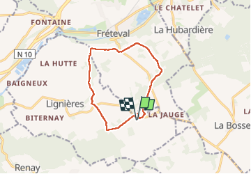
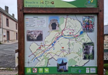
Randonnée Marche de 10,8 km à découvrir à Centre-Val de Loire, Loir-et-Cher, Lignières. Cette randonnée est proposée par guydu41.
Description
Le circuit commence depuis une petite zone où l'on peut stationner derrière l'abribus sur la Route du Petit Rocheux à l'intersection avec la D12, Lignières 41160.
Depuis votre véhicule se diriger vers la D12, tourner à droite puis un peu plus loin prendre l'allée à gauche vers le Château des Énigmes pour admirer depuis l'entrée du parc le Château de Rocheux.
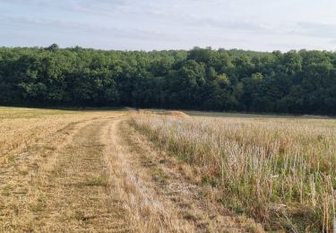
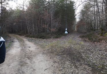
Revenir vers la D12 puis cent mètres plus loin emprunter vers la gauche un chemin balisé jaune (PR) qui va longer un bois puis après le franchissement de la D2 traverser un autre bois.
Le circuit à travers champs va couper de nouveau la D2, emprunter une petite route communale vers les Hauts de Courcelles, traverser le Bois du Refuge grâce à un chemin, se diriger vers le hameau "les Haies" pour revenir au point de départ.
Localisation
Commentaires
Randonnées à proximité
![Randonnée Marche Fréteval - Fréteval - Champs Bois Grotte Étang - Photo](https://media.geolcdn.com/t/375/260/34045ca4-04f5-42e9-b8a9-99df3505cc2e.jpg&format=jpg&maxdim=2)
![Marche Marche](https://static1.geolcdn.com/sitytour/trail-icons/101.png)
Marche
![](/images/other/stat-length.png)
![](https://static1.geolcdn.com/siteimages/upload/files/16400158638029165_repeat_loop_refresh_sync_direction_icon.png)
![Randonnée Marche La Chapelle-Enchérie - La Chapelle-Enchérie - Bois de Bricsard - Photo](https://media.geolcdn.com/t/375/260/0862f641-e319-4701-963f-83d27a100897.jpg&format=jpg&maxdim=2)
![Marche Marche](https://static1.geolcdn.com/sitytour/trail-icons/101.png)
Marche
![](/images/other/stat-length.png)
![](https://static1.geolcdn.com/siteimages/upload/files/16400158638029165_repeat_loop_refresh_sync_direction_icon.png)
![Randonnée Marche Fréteval - Fréteval - Etang Champs Bois Donjon - Photo](https://media.geolcdn.com/t/375/260/dbe14c3b-b458-4462-84f4-1045ca1ab83b.jpg&format=jpg&maxdim=2)
![Marche Marche](https://static1.geolcdn.com/sitytour/trail-icons/101.png)
Marche
![](/images/other/stat-length.png)
![](https://static1.geolcdn.com/siteimages/upload/files/16400158638029165_repeat_loop_refresh_sync_direction_icon.png)
![Randonnée Marche Renay - Renay - Champs Bois Chapelle Eglise - Photo](https://media.geolcdn.com/t/375/260/ddc8d202-9993-403c-b2f2-d3983276bdc7.jpg&format=jpg&maxdim=2)
![Marche Marche](https://static1.geolcdn.com/sitytour/trail-icons/101.png)
Marche
![](/images/other/stat-length.png)
![](https://static1.geolcdn.com/siteimages/upload/files/16400158638029165_repeat_loop_refresh_sync_direction_icon.png)
![Randonnée Marche Fréteval - Fréteval - L'histoire en chemin - Photo](https://media.geolcdn.com/t/375/260/dd7bbd73-a31b-4596-b9ef-a372bb9665f7.jpg&format=jpg&maxdim=2)
![Marche Marche](https://static1.geolcdn.com/sitytour/trail-icons/101.png)
Marche
![](/images/other/stat-length.png)
![](https://static1.geolcdn.com/siteimages/upload/files/16400158638029165_repeat_loop_refresh_sync_direction_icon.png)
![Randonnée Vélo Fréteval - Circuit des 2 coteaux - Fréteval - Photo](https://media.geolcdn.com/t/375/260/ext.jpg?maxdim=2&url=https%3A%2F%2Fservices.sitytrail.com%2FGeolivesWS%2FDownloadMedia.ashx%3FTrailID%3D112184%26Media%3D10045_6.jpg)
![Vélo Vélo](https://static1.geolcdn.com/sitytour/trail-icons/200.png)
Vélo
![](/images/other/stat-length.png)
![](https://static1.geolcdn.com/siteimages/upload/files/16400158638029165_repeat_loop_refresh_sync_direction_icon.png)
![Randonnée V.T.T. Morée - Circuit de vallées et coteaux n° 3 - Morée - Photo](https://media.geolcdn.com/t/375/260/ext.jpg?maxdim=2&url=https%3A%2F%2Fservices.sitytrail.com%2FGeolivesWS%2FDownloadMedia.ashx%3FTrailID%3D105964%26Media%3D10046_6.jpg)
![V.T.T. V.T.T.](https://static1.geolcdn.com/sitytour/trail-icons/202.png)
V.T.T.
![](/images/other/stat-length.png)
![](https://static1.geolcdn.com/siteimages/upload/files/16400158638029165_repeat_loop_refresh_sync_direction_icon.png)
![Randonnée Marche La Chapelle-Enchérie - balade la chapelle en encherie - Photo](https://media.geolcdn.com/t/375/260/9ee6cf75-db14-41fa-9088-ae110956876b.jpg&format=jpg&maxdim=2)
![Marche Marche](https://static1.geolcdn.com/sitytour/trail-icons/101.png)
Marche
![](/images/other/stat-length.png)
![](https://static1.geolcdn.com/siteimages/upload/files/16400158638029165_repeat_loop_refresh_sync_direction_icon.png)
![Randonnée Marche Fréteval - freteval 12 kms - Photo](https://media.geolcdn.com/t/375/260/ext.jpg?maxdim=2&url=https%3A%2F%2Fstatic1.geolcdn.com%2Fsiteimages%2Fupload%2Ffiles%2F1553511878bg_sport_marche.png)
![Marche Marche](https://static1.geolcdn.com/sitytour/trail-icons/101.png)
Marche
![](/images/other/stat-length.png)
![](https://static1.geolcdn.com/siteimages/upload/files/16400158638029165_repeat_loop_refresh_sync_direction_icon.png)