![](/images/other/stat-length.png)
![Randonnée Marche Limbourg - 20240503 - Moniteurs Coingsoux - 7.2 Km - Photo](https://media.geolcdn.com/t/1900/400/e878085f-4419-412b-9314-748dd585c98e.jpeg&format=pjpeg&maxdim=2)
20240503 - Moniteurs Coingsoux - 7.2 Km
pierreh01
Utilisateur GUIDE
![Longueur](/images/other/stat-length.png)
Longueur
7,2 km
![Altitude max](https://static1.geolcdn.com/siteimages/upload/files/1508320355ic_sort_altitude_max_24dp.png)
Altitude max
313 m
![Dénivelé positif](https://static1.geolcdn.com/siteimages/upload/files/1508320355ic_sort_den_pos_24dp.png)
Dénivelé positif
152 m
![Km-Effort](/images/other/stat-length.png)
Km-Effort
9,2 km
![Altitude min](https://static1.geolcdn.com/siteimages/upload/files/1508320355ic_sort_altitude_min_24dp.png)
Altitude min
221 m
![Dénivelé négatif](https://static1.geolcdn.com/siteimages/upload/files/1508320355ic_sort_den_neg_24dp.png)
Dénivelé négatif
148 m
![Boucle](https://static1.geolcdn.com/siteimages/upload/files/16400158638029165_repeat_loop_refresh_sync_direction_icon.png)
Boucle
Oui
Date de création :
2024-05-03 13:33:30.164
Dernière modification :
2024-05-04 18:04:45.271
![Marche](https://static1.geolcdn.com/sitytour/trail-icons/101.png)
2h28
Difficulté : Moyen
![Scannez ce code QR pour ouvrir la randonnée dans l'application SityTrail](https://capi.geolives.com/qq0zvz2zws4bq2lad0pu/sitytour/trails/4039387/qr.png?size=200)
Application GPS de randonnée GRATUITE
À propos
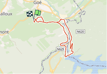
Randonnée Marche de 7,2 km à découvrir à Wallonie, Liège, Limbourg. Cette randonnée est proposée par pierreh01.
Description
Samedi 3 mai 2024 : Retrouvailles des anciens "Moniteurs Mutuelle".
C'est sous une météo très agréable que notre guide du jour, Serge, nous a emmené dans les bois proches de la Gileppe avec petit passage sur le barrage.
Distance mesurée avec Sity Trail.
Localisation
Pays :
Belgique
Région :
Wallonie
Département/Province :
Liège
Commune :
Limbourg
Localité :
Unknown
Départ:(Dec)
Départ:(UTM)
709033 ; 5609763 (31U) N.
Commentaires
Randonnées à proximité
![Randonnée Marche Limbourg - RB-Lg-28_Limbourg - Photo](https://media.geolcdn.com/t/375/260/ext.jpg?maxdim=2&url=https%3A%2F%2Fservices.sitytrail.com%2FGeolivesWS%2FDownloadMedia.ashx%3FTrailID%3D402093%26Media%3D979895a6-f139-4f7a-8335-2e926c1b89c7.jpg)
![Marche Marche](https://static1.geolcdn.com/sitytour/trail-icons/101.png)
RB-Lg-28_Limbourg
Marche
(5)
Limbourg,
Wallonie,
Liège,
Belgique
![](/images/other/stat-length.png)
19,9 km | 26 km-effort
5h 49min
![](https://static1.geolcdn.com/siteimages/upload/files/16400158638029165_repeat_loop_refresh_sync_direction_icon.png)
Oui
![Randonnée Marche Verviers - Grand vivier - Cossart - Photo](https://media.geolcdn.com/t/375/260/ext.jpg?maxdim=2&url=https%3A%2F%2Fstatic1.geolcdn.com%2Fsiteimages%2Fupload%2Ffiles%2F1553511878bg_sport_marche.png)
![Marche Marche](https://static1.geolcdn.com/sitytour/trail-icons/101.png)
Grand vivier - Cossart
Marche
Facile
(5)
Verviers,
Wallonie,
Liège,
Belgique
![](/images/other/stat-length.png)
4,7 km | 6,4 km-effort
1h 26min
![](https://static1.geolcdn.com/siteimages/upload/files/16400158638029165_repeat_loop_refresh_sync_direction_icon.png)
Oui
![Randonnée Marche Jalhay - La Gileppe - Bois de la Borchêne - Photo](https://media.geolcdn.com/t/375/260/e6c1c191-9060-48ef-8a65-d77cc5b69a34.jpg&format=jpg&maxdim=2)
![Marche Marche](https://static1.geolcdn.com/sitytour/trail-icons/101.png)
La Gileppe - Bois de la Borchêne
Marche
Facile
(3)
Jalhay,
Wallonie,
Liège,
Belgique
![](/images/other/stat-length.png)
7,6 km | 9,8 km-effort
2h 13min
![](https://static1.geolcdn.com/siteimages/upload/files/16400158638029165_repeat_loop_refresh_sync_direction_icon.png)
Oui
![Randonnée Marche Baelen - Baelen - Eupen 🎄🎅 - Membach - Photo](https://media.geolcdn.com/t/375/260/d50227a7-424d-470e-90d5-87ebd384de36.jpg&format=jpg&maxdim=2)
![Marche Marche](https://static1.geolcdn.com/sitytour/trail-icons/101.png)
Baelen - Eupen 🎄🎅 - Membach
Marche
Facile
(1)
Baelen,
Wallonie,
Liège,
Belgique
![](/images/other/stat-length.png)
13,3 km | 15,6 km-effort
3h 32min
![](https://static1.geolcdn.com/siteimages/upload/files/16400158638029165_repeat_loop_refresh_sync_direction_icon.png)
Oui
![Randonnée Marche Jalhay - Jalhay-Royompré_-_Balade 47 - Photo](https://media.geolcdn.com/t/375/260/94c262e0-20e7-4ae2-8b45-01b4c31da73b.jpg&format=jpg&maxdim=2)
![Marche Marche](https://static1.geolcdn.com/sitytour/trail-icons/101.png)
Jalhay-Royompré_-_Balade 47
Marche
Facile
(2)
Jalhay,
Wallonie,
Liège,
Belgique
![](/images/other/stat-length.png)
11 km | 13,9 km-effort
3h 9min
![](https://static1.geolcdn.com/siteimages/upload/files/16400158638029165_repeat_loop_refresh_sync_direction_icon.png)
Oui
![Randonnée Marche Baelen - La Montagne du Dragon - Photo](https://media.geolcdn.com/t/375/260/3a1bc634-7bf5-4748-bbb3-513b265a48b5.jpg&format=jpg&maxdim=2)
![Marche Marche](https://static1.geolcdn.com/sitytour/trail-icons/101.png)
La Montagne du Dragon
Marche
Facile
(1)
Baelen,
Wallonie,
Liège,
Belgique
![](/images/other/stat-length.png)
16,2 km | 21 km-effort
3h 21min
![](https://static1.geolcdn.com/siteimages/upload/files/16400158638029165_repeat_loop_refresh_sync_direction_icon.png)
Oui
![Marche Marche](https://static1.geolcdn.com/sitytour/trail-icons/101.png)
20210205 - La Gileppe 7.3 Km
Marche
Moyen
(1)
Jalhay,
Wallonie,
Liège,
Belgique
![](/images/other/stat-length.png)
7,6 km | 9,9 km-effort
2h 24min
![](https://static1.geolcdn.com/siteimages/upload/files/16400158638029165_repeat_loop_refresh_sync_direction_icon.png)
Oui
![Randonnée Marche Limbourg - RL-GG-11_Dolhain-Gileppe_Pepinster - Photo](https://media.geolcdn.com/t/375/260/9cf2c240-5913-4088-b4f6-6c0e1fae0233.jpg&format=jpg&maxdim=2)
![Marche Marche](https://static1.geolcdn.com/sitytour/trail-icons/101.png)
RL-GG-11_Dolhain-Gileppe_Pepinster
Marche
Très difficile
(2)
Limbourg,
Wallonie,
Liège,
Belgique
![](/images/other/stat-length.png)
20 km | 26 km-effort
5h 33min
![](https://static1.geolcdn.com/siteimages/upload/files/16400158638029165_repeat_loop_refresh_sync_direction_icon.png)
Non
![Randonnée Marche Limbourg - 20200606 - Hèvremont 8 Km - Photo](https://media.geolcdn.com/t/375/260/8311f513-ce09-455a-b0ac-51a7423b07df.jpg&format=jpg&maxdim=2)
![Marche Marche](https://static1.geolcdn.com/sitytour/trail-icons/101.png)
20200606 - Hèvremont 8 Km
Marche
Difficile
(1)
Limbourg,
Wallonie,
Liège,
Belgique
![](/images/other/stat-length.png)
7,9 km | 10,7 km-effort
1h 34min
![](https://static1.geolcdn.com/siteimages/upload/files/16400158638029165_repeat_loop_refresh_sync_direction_icon.png)
Oui