![](/images/other/stat-length.png)
![Randonnée Marche Urbasa - Arche de Portupekoleze et grotte de Lezaundi de la venta de Lizarraga - Photo](https://media.geolcdn.com/t/1900/400/75529867-0d72-4e6e-9500-320394cb120a.jpg&format=pjpeg&maxdim=2)
Arche de Portupekoleze et grotte de Lezaundi de la venta de Lizarraga
DECHAMPD
Utilisateur
![Longueur](/images/other/stat-length.png)
![Altitude max](https://static1.geolcdn.com/siteimages/upload/files/1508320355ic_sort_altitude_max_24dp.png)
![Dénivelé positif](https://static1.geolcdn.com/siteimages/upload/files/1508320355ic_sort_den_pos_24dp.png)
![Km-Effort](/images/other/stat-length.png)
![Altitude min](https://static1.geolcdn.com/siteimages/upload/files/1508320355ic_sort_altitude_min_24dp.png)
![Dénivelé négatif](https://static1.geolcdn.com/siteimages/upload/files/1508320355ic_sort_den_neg_24dp.png)
![Boucle](https://static1.geolcdn.com/siteimages/upload/files/16400158638029165_repeat_loop_refresh_sync_direction_icon.png)
![Marche](https://static1.geolcdn.com/sitytour/trail-icons/101.png)
3h46
Difficulté : Difficile
![Scannez ce code QR pour ouvrir la randonnée dans l'application SityTrail](https://capi.geolives.com/qq0zvz2zws4bq2lad0pu/sitytour/trails/4033394/qr.png?size=200)
Application GPS de randonnée GRATUITE
À propos
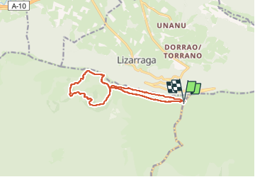
Randonnée Marche de 12,5 km à découvrir à Navarre, Inconnu, Urbasa. Cette randonnée est proposée par DECHAMPD.
Description
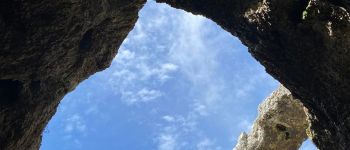
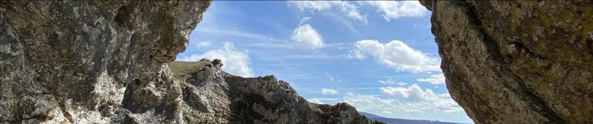
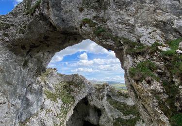
Arc de Portupekoleze et grotte de Lezaundi à venta Lizarraga
C'est un endroit magnifique !
Il est un peu caché même si comme sur les cartes on le voit d'en haut, on sait comment y arriver.
Vous vous garez au port de Lizarraga, c'est facile car il y a beaucoup d'espace disponible et il y a aussi une taverne.
Il y a un petit chemin qui, si nous le suivons, je pense que nous pouvons atteindre l'ermitage de San Adrian, mais il faut faire un détour bien avant. Dans mon cas j'ai fait le premier détour à droite, vous trouverez une maison mais il faut continuer à monter et une fois en haut vous pourrez voir ce bel endroit !
L'une des choses qui a le plus retenu mon attention, c'est qu'on pouvait voir San Donato devant et bien, l'arc en lui-même est spectaculaire!
Localisation
Commentaires
Randonnées à proximité
![Marche Marche](https://static1.geolcdn.com/sitytour/trail-icons/101.png)
Marche
![](/images/other/stat-length.png)
![](https://static1.geolcdn.com/siteimages/upload/files/16400158638029165_repeat_loop_refresh_sync_direction_icon.png)
![Randonnée Marche Urbasa - Pörtupekoleze Sierra de Adia 2024/09/09 - Photo](https://media.geolcdn.com/t/375/260/acfc5746-5ee5-4513-b79e-f2450f10ec20.jpg&format=jpg&maxdim=2)
![Marche Marche](https://static1.geolcdn.com/sitytour/trail-icons/101.png)
Marche
![](/images/other/stat-length.png)
![](https://static1.geolcdn.com/siteimages/upload/files/16400158638029165_repeat_loop_refresh_sync_direction_icon.png)
![Randonnée Marche Andia - 3 sommets et Portupekoleze, grotte de Lezaundi Puerto Lizarraga Cueva de Arleze y San Adrián. - Photo](https://media.geolcdn.com/t/375/260/f69d411e-d857-4931-b55a-4c0528a784d2.jpeg&format=jpg&maxdim=2)
![Marche Marche](https://static1.geolcdn.com/sitytour/trail-icons/101.png)
Marche
![](/images/other/stat-length.png)
![](https://static1.geolcdn.com/siteimages/upload/files/16400158638029165_repeat_loop_refresh_sync_direction_icon.png)