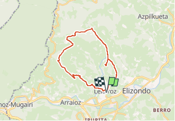
![](/images/other/stat-length.png)
![Randonnée Marche Baztan - Le Legate 870m et Munho 432m depuis Elizondo/Lekaroz 11/09/2024 - Photo](https://media.geolcdn.com/t/1900/400/3a7849ca-5caa-42b4-972a-045a6773fe6b.png&format=pjpeg&maxdim=2)
Le Legate 870m et Munho 432m depuis Elizondo/Lekaroz 11/09/2024
DECHAMPD
Utilisateur
![Longueur](/images/other/stat-length.png)
![Altitude max](https://static1.geolcdn.com/siteimages/upload/files/1508320355ic_sort_altitude_max_24dp.png)
![Dénivelé positif](https://static1.geolcdn.com/siteimages/upload/files/1508320355ic_sort_den_pos_24dp.png)
![Km-Effort](/images/other/stat-length.png)
![Altitude min](https://static1.geolcdn.com/siteimages/upload/files/1508320355ic_sort_altitude_min_24dp.png)
![Dénivelé négatif](https://static1.geolcdn.com/siteimages/upload/files/1508320355ic_sort_den_neg_24dp.png)
![Boucle](https://static1.geolcdn.com/siteimages/upload/files/16400158638029165_repeat_loop_refresh_sync_direction_icon.png)
![Marche](https://static1.geolcdn.com/sitytour/trail-icons/101.png)
5h46
Difficulté : Très difficile
![Scannez ce code QR pour ouvrir la randonnée dans l'application SityTrail](https://capi.geolives.com/qq0zvz2zws4bq2lad0pu/sitytour/trails/4033283/qr.png?size=200)
Application GPS de randonnée GRATUITE
À propos
Randonnée Marche de 14,5 km à découvrir à Navarre, Inconnu, Baztan. Cette randonnée est proposée par DECHAMPD.
Description
Au départ de LEKAROZ ( petit village près d'ELIZONDO), circuit ayant pour objectif le LEGATE 870m. On gravira au passage le MUNHO 432m ( lors de la montée)
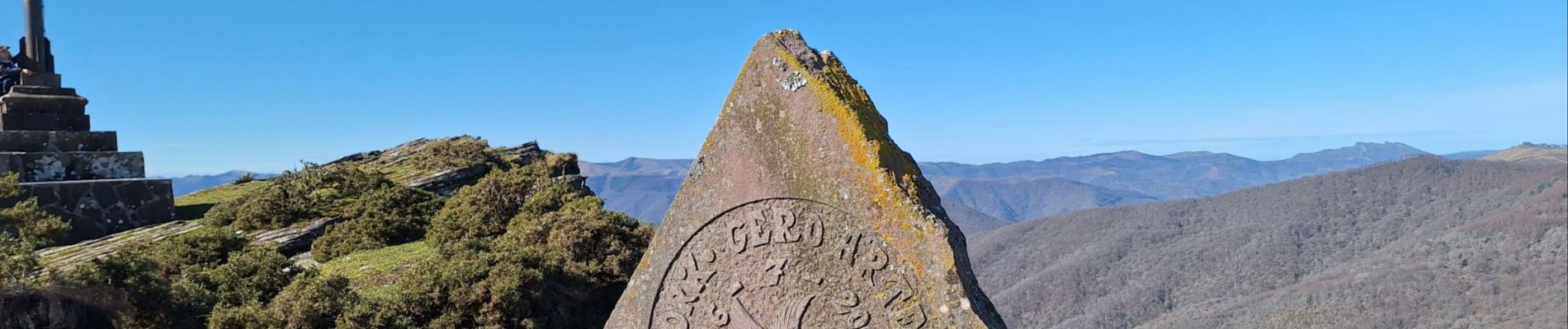
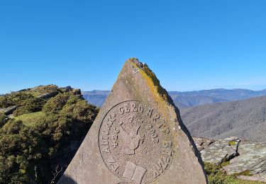
Ue imprenable à 360° après une bonne grimpette
Vue sur l’AIKOLEGUI, MENDAUR et AUZA.
Dénivelé 715m Distance 14 km. Effort 23km.
https://maps.app.goo.gl/pezxBHUSkxWhypZW9
54 km 1h03.
Dantxaria N-121-B
ELIZONDO
Env 3km à droite rond point NA-4403
LEKAROZ
Localisation
Commentaires
Randonnées à proximité
![Randonnée Marche Baztan - Le Legare 2024/08/16 - Photo](https://media.geolcdn.com/t/375/260/b9d59c9e-9c2d-4d32-b82f-56e0018c96e6.jpg&format=jpg&maxdim=2)
![Marche Marche](https://static1.geolcdn.com/sitytour/trail-icons/101.png)
Marche
![](/images/other/stat-length.png)
![](https://static1.geolcdn.com/siteimages/upload/files/16400158638029165_repeat_loop_refresh_sync_direction_icon.png)
![Randonnée Marche Baztan - 2024/05/28 Elizondo départ Parking - Photo](https://media.geolcdn.com/t/375/260/5c2f942c-76ba-4b7a-a400-474036e6852e.jpg&format=jpg&maxdim=2)
![Marche Marche](https://static1.geolcdn.com/sitytour/trail-icons/101.png)
Marche
![](/images/other/stat-length.png)
![](https://static1.geolcdn.com/siteimages/upload/files/16400158638029165_repeat_loop_refresh_sync_direction_icon.png)
![Randonnée Marche Baztan - Le Legate depuis Lekaroz - Photo](https://media.geolcdn.com/t/375/260/88a262ce-e547-48ba-a39b-a474213cc0c5.jpg&format=jpg&maxdim=2)
![Marche Marche](https://static1.geolcdn.com/sitytour/trail-icons/101.png)
Marche
![](/images/other/stat-length.png)
![](https://static1.geolcdn.com/siteimages/upload/files/16400158638029165_repeat_loop_refresh_sync_direction_icon.png)
![Randonnée Randonnée équestre Baztan - Elizondo - Urdax - Photo](https://media.geolcdn.com/t/375/260/2940b90d-34c9-430c-88c8-3b80dad8731b.jpg&format=jpg&maxdim=2)
![Randonnée équestre Randonnée équestre](https://static1.geolcdn.com/sitytour/trail-icons/301.png)
Randonnée équestre
![](/images/other/stat-length.png)
![](https://static1.geolcdn.com/siteimages/upload/files/16400158638029165_repeat_loop_refresh_sync_direction_icon.png)
![Randonnée Marche Baztan - Umboto Larondo depuis Azpikueta - Photo](https://media.geolcdn.com/t/375/260/2e52e0d7-98cc-42d6-99d8-37338c4b3887.jpg&format=jpg&maxdim=2)
![Marche Marche](https://static1.geolcdn.com/sitytour/trail-icons/101.png)
Marche
![](/images/other/stat-length.png)
![](https://static1.geolcdn.com/siteimages/upload/files/16400158638029165_repeat_loop_refresh_sync_direction_icon.png)
![Randonnée Marche Baztan - BURGA d'Arizkun, retour par Erratzu 2020 11 17 - Photo](https://media.geolcdn.com/t/375/260/ext.jpg?maxdim=2&url=https%3A%2F%2Fstatic1.geolcdn.com%2Fsiteimages%2Fupload%2Ffiles%2F1553511878bg_sport_marche.png)
![Marche Marche](https://static1.geolcdn.com/sitytour/trail-icons/101.png)
Marche
![](/images/other/stat-length.png)
![](https://static1.geolcdn.com/siteimages/upload/files/16400158638029165_repeat_loop_refresh_sync_direction_icon.png)
![Randonnée Marche Baztan - GR 11 Stage 3: Elizondo - Urkiaga Pass - Photo](https://media.geolcdn.com/t/375/260/ext.jpg?maxdim=2&url=https%3A%2F%2Fstatic1.geolcdn.com%2Fsiteimages%2Fupload%2Ffiles%2F1553511878bg_sport_marche.png)
![Marche Marche](https://static1.geolcdn.com/sitytour/trail-icons/101.png)
Marche
![](/images/other/stat-length.png)
![](https://static1.geolcdn.com/siteimages/upload/files/16400158638029165_repeat_loop_refresh_sync_direction_icon.png)
![Randonnée Marche Baztan - Le Legate - Photo](https://media.geolcdn.com/t/375/260/ext.jpg?maxdim=2&url=https%3A%2F%2Fstatic1.geolcdn.com%2Fsiteimages%2Fupload%2Ffiles%2F1553511878bg_sport_marche.png)
![Marche Marche](https://static1.geolcdn.com/sitytour/trail-icons/101.png)
![Randonnée Marche Baztan - Pic Legate en boucle - Photo](https://media.geolcdn.com/t/375/260/ext.jpg?maxdim=2&url=https%3A%2F%2Fstatic1.geolcdn.com%2Fsiteimages%2Fupload%2Ffiles%2F1553511878bg_sport_marche.png)
![Marche Marche](https://static1.geolcdn.com/sitytour/trail-icons/101.png)
Marche
![](/images/other/stat-length.png)
![](https://static1.geolcdn.com/siteimages/upload/files/16400158638029165_repeat_loop_refresh_sync_direction_icon.png)