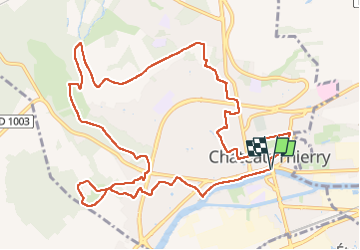
![](/images/other/stat-length.png)
![Randonnée Marche Château-Thierry - Les Vignes Castelles trace du 28-04-2024 - Photo](https://media.geolcdn.com/t/1900/400/4b525fce-e0c7-44a3-ac4d-c251652c2d56.jpg&format=pjpeg&maxdim=2)
Les Vignes Castelles trace du 28-04-2024
VANDERPUTTENMi
Utilisateur GUIDE
![Longueur](/images/other/stat-length.png)
![Altitude max](https://static1.geolcdn.com/siteimages/upload/files/1508320355ic_sort_altitude_max_24dp.png)
![Dénivelé positif](https://static1.geolcdn.com/siteimages/upload/files/1508320355ic_sort_den_pos_24dp.png)
![Km-Effort](/images/other/stat-length.png)
![Altitude min](https://static1.geolcdn.com/siteimages/upload/files/1508320355ic_sort_altitude_min_24dp.png)
![Dénivelé négatif](https://static1.geolcdn.com/siteimages/upload/files/1508320355ic_sort_den_neg_24dp.png)
![Boucle](https://static1.geolcdn.com/siteimages/upload/files/16400158638029165_repeat_loop_refresh_sync_direction_icon.png)
![Marche](https://static1.geolcdn.com/sitytour/trail-icons/101.png)
3h43
Difficulté : Difficile
![Scannez ce code QR pour ouvrir la randonnée dans l'application SityTrail](https://capi.geolives.com/qq0zvz2zws4bq2lad0pu/sitytour/trails/4032899/qr.png?size=200)
Application GPS de randonnée GRATUITE
À propos
Randonnée Marche de 12,6 km à découvrir à Hauts-de-France, Aisne, Château-Thierry. Cette randonnée est proposée par VANDERPUTTENMi.
Description
Un circuit exclusivement communal depuis la maison du tourisme "les Portes de la Champagne".
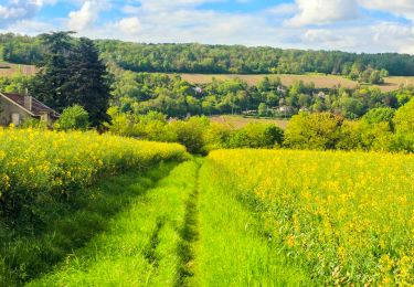
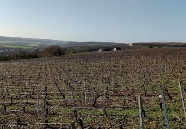
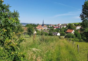
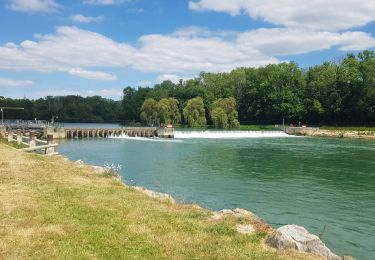
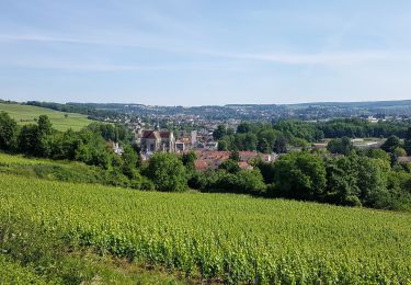
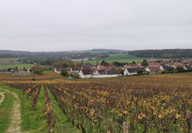
De la rivière Marne au monument Américain, du marais aux vignes de Vincelles, des vignes des Blanchards au vieux Château.
De belles vues sur la vallée et la ville depuis les hauteurs.
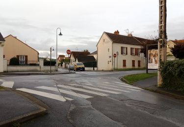
Un patrimoine intra-muros à découvrir en arpentant des sentes d'un quartier à l'autre.
Localisation
Commentaires
Randonnées à proximité
![Randonnée Marche Château-Thierry - Château-Thierry du 20-10-2024 - Photo](https://media.geolcdn.com/t/375/260/01f4364c-7132-4755-84cb-ad0105634b93.jpg&format=jpg&maxdim=2)
![Marche Marche](https://static1.geolcdn.com/sitytour/trail-icons/101.png)
Marche
![](/images/other/stat-length.png)
![](https://static1.geolcdn.com/siteimages/upload/files/16400158638029165_repeat_loop_refresh_sync_direction_icon.png)
![Randonnée Marche Château-Thierry - Le chemin de St Colomban en IDF Etape 1 Chateau Thierry - Nanteuil sur Marne - Photo](https://media.geolcdn.com/t/375/260/9609d3ad-ab5e-4f8f-9f67-aa273e117c14.jpg&format=jpg&maxdim=2)
![Marche Marche](https://static1.geolcdn.com/sitytour/trail-icons/101.png)
Marche
![](/images/other/stat-length.png)
![](https://static1.geolcdn.com/siteimages/upload/files/16400158638029165_repeat_loop_refresh_sync_direction_icon.png)
![Randonnée Marche Château-Thierry - Les vignes Castelles - version 8 km - Photo](https://media.geolcdn.com/t/375/260/02397956-c095-41df-bc0b-2c08db7076aa.jpg&format=jpg&maxdim=2)
![Marche Marche](https://static1.geolcdn.com/sitytour/trail-icons/101.png)
Marche
![](/images/other/stat-length.png)
![](https://static1.geolcdn.com/siteimages/upload/files/16400158638029165_repeat_loop_refresh_sync_direction_icon.png)
![Randonnée Marche Chierry - Chierry - Photo](https://media.geolcdn.com/t/375/260/ext.jpg?maxdim=2&url=https%3A%2F%2Fstatic1.geolcdn.com%2Fsiteimages%2Fupload%2Ffiles%2F1553511878bg_sport_marche.png)
![Marche Marche](https://static1.geolcdn.com/sitytour/trail-icons/101.png)
Marche
![](/images/other/stat-length.png)
![](https://static1.geolcdn.com/siteimages/upload/files/16400158638029165_repeat_loop_refresh_sync_direction_icon.png)
![Randonnée Marche Nesles-la-Montagne - Nesles la Montagne du 02/06/2020 - Photo](https://media.geolcdn.com/t/375/260/e9e49450-fac4-4ee3-aafc-a88d23d73e0c.jpg&format=jpg&maxdim=2)
![Marche Marche](https://static1.geolcdn.com/sitytour/trail-icons/101.png)
Marche
![](/images/other/stat-length.png)
![](https://static1.geolcdn.com/siteimages/upload/files/16400158638029165_repeat_loop_refresh_sync_direction_icon.png)
![Randonnée V.T.T. Château-Thierry - Château / Mont St Père / Azy / Château - Photo](https://media.geolcdn.com/t/375/260/faaee0cb-6e62-4da4-afa4-df40725828c1.jpg&format=jpg&maxdim=2)
![V.T.T. V.T.T.](https://static1.geolcdn.com/sitytour/trail-icons/202.png)
V.T.T.
![](/images/other/stat-length.png)
![](https://static1.geolcdn.com/siteimages/upload/files/16400158638029165_repeat_loop_refresh_sync_direction_icon.png)
![Randonnée Marche Château-Thierry - Château - Aulnois - Château du 26/05/2020 - Photo](https://media.geolcdn.com/t/375/260/5c13f2d8-e6c8-4489-a7e8-8e373eb07263.jpg&format=jpg&maxdim=2)
![Marche Marche](https://static1.geolcdn.com/sitytour/trail-icons/101.png)
Marche
![](/images/other/stat-length.png)
![](https://static1.geolcdn.com/siteimages/upload/files/16400158638029165_repeat_loop_refresh_sync_direction_icon.png)
![Randonnée Course à pied Verdilly - Verdilly Balcons de la Marne - Photo](https://media.geolcdn.com/t/375/260/ext.jpg?maxdim=2&url=https%3A%2F%2Fstatic1.geolcdn.com%2Fsiteimages%2Fupload%2Ffiles%2F1524743154running.jpg)
![Course à pied Course à pied](https://static1.geolcdn.com/sitytour/trail-icons/103.png)
Course à pied
![](/images/other/stat-length.png)
![](https://static1.geolcdn.com/siteimages/upload/files/16400158638029165_repeat_loop_refresh_sync_direction_icon.png)
![Randonnée Marche Château-Thierry - RP51-06 Château-Thierry à Nogent-l'Artaud - Photo](https://media.geolcdn.com/t/375/260/7ec1e237-b08e-4e51-8cdb-e2df6d1283d7.jpg&format=jpg&maxdim=2)
![Marche Marche](https://static1.geolcdn.com/sitytour/trail-icons/101.png)
Marche
![](/images/other/stat-length.png)
![](https://static1.geolcdn.com/siteimages/upload/files/16400158638029165_repeat_loop_refresh_sync_direction_icon.png)