![](/images/other/stat-length.png)
![Randonnée Marche Chevrier - Mont Vuache - Photo](https://media.geolcdn.com/t/1900/400/68069326-1375-49b0-91de-e2aebecc0c14.jpg&format=pjpeg&maxdim=2)
Mont Vuache
perenhout
Utilisateur
![Longueur](/images/other/stat-length.png)
Longueur
3,2 km
![Altitude max](https://static1.geolcdn.com/siteimages/upload/files/1508320355ic_sort_altitude_max_24dp.png)
Altitude max
936 m
![Dénivelé positif](https://static1.geolcdn.com/siteimages/upload/files/1508320355ic_sort_den_pos_24dp.png)
Dénivelé positif
54 m
![Km-Effort](/images/other/stat-length.png)
Km-Effort
5 km
![Altitude min](https://static1.geolcdn.com/siteimages/upload/files/1508320355ic_sort_altitude_min_24dp.png)
Altitude min
551 m
![Dénivelé négatif](https://static1.geolcdn.com/siteimages/upload/files/1508320355ic_sort_den_neg_24dp.png)
Dénivelé négatif
396 m
![Boucle](https://static1.geolcdn.com/siteimages/upload/files/16400158638029165_repeat_loop_refresh_sync_direction_icon.png)
Boucle
Non
Date de création :
2024-04-27 11:05:09.946
Dernière modification :
2024-04-27 12:28:58.203
![Marche](https://static1.geolcdn.com/sitytour/trail-icons/101.png)
1h22
Difficulté : Facile
![Scannez ce code QR pour ouvrir la randonnée dans l'application SityTrail](https://capi.geolives.com/qq0zvz2zws4bq2lad0pu/sitytour/trails/4031340/qr.png?size=200)
Application GPS de randonnée GRATUITE
À propos
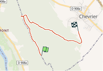
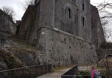
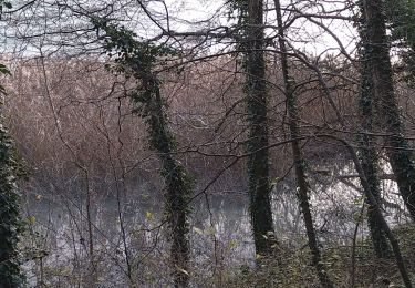
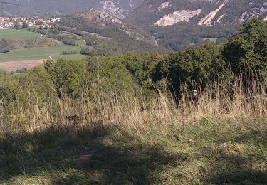
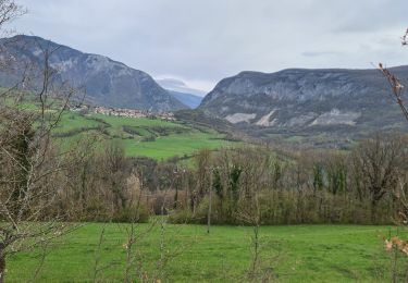
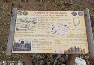
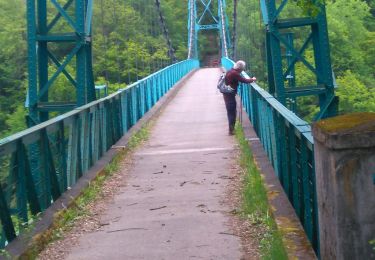
Randonnée Marche de 3,2 km à découvrir à Auvergne-Rhône-Alpes, Haute-Savoie, Chevrier. Cette randonnée est proposée par perenhout .
Description
Chevrier, Chapelle de l'Oratoire et retour. L'aller n'a pas fonctionné (il faut décocher l'économie d'énergie de la batterie).
Localisation
Pays :
France
Région :
Auvergne-Rhône-Alpes
Département/Province :
Haute-Savoie
Commune :
Chevrier
Localité :
Unknown
Départ:(Dec)
Départ:(UTM)
724447 ; 5109259 (31T) N.
Commentaires
Randonnées à proximité
![Randonnée Marche Chevrier - Défilé de l'écluse - Photo](https://media.geolcdn.com/t/375/260/a3cfad9a-ab23-4421-9d30-a277eeba36d0.jpg&format=jpg&maxdim=2)
![Marche Marche](https://static1.geolcdn.com/sitytour/trail-icons/101.png)
Défilé de l'écluse
Marche
Difficile
Chevrier,
Auvergne-Rhône-Alpes,
Haute-Savoie,
France
![](/images/other/stat-length.png)
19,4 km | 27 km-effort
4h 35min
![](https://static1.geolcdn.com/siteimages/upload/files/16400158638029165_repeat_loop_refresh_sync_direction_icon.png)
Oui
![Randonnée Marche Éloise - b) Etapa 2 - Photo](https://media.geolcdn.com/t/375/260/ext.jpg?maxdim=2&url=https%3A%2F%2Fservices.sitytrail.com%2FGeolivesWS%2FDownloadMedia.ashx%3FTrailID%3D710908%26Media%3D20170301122047.jpg)
![Marche Marche](https://static1.geolcdn.com/sitytour/trail-icons/101.png)
b) Etapa 2
Marche
Difficile
Éloise,
Auvergne-Rhône-Alpes,
Haute-Savoie,
France
![](/images/other/stat-length.png)
25 km | 34 km-effort
6h 3min
![](https://static1.geolcdn.com/siteimages/upload/files/16400158638029165_repeat_loop_refresh_sync_direction_icon.png)
Non
![Randonnée Marche Léaz - Fort l'Ecluse-Leaz - Photo](https://media.geolcdn.com/t/375/260/35b54d96-9be8-4c5d-90bf-ded96b2e7742.jpg&format=jpg&maxdim=2)
![Marche Marche](https://static1.geolcdn.com/sitytour/trail-icons/101.png)
Fort l'Ecluse-Leaz
Marche
Moyen
Léaz,
Auvergne-Rhône-Alpes,
Ain,
France
![](/images/other/stat-length.png)
14,5 km | 23 km-effort
4h 14min
![](https://static1.geolcdn.com/siteimages/upload/files/16400158638029165_repeat_loop_refresh_sync_direction_icon.png)
Oui
![Randonnée Marche Léaz - Leaz Fort l'écluse - Photo](https://media.geolcdn.com/t/375/260/8e7873a0-22c4-4f74-aaa2-1863eb49e87f.jpg&format=jpg&maxdim=2)
![Marche Marche](https://static1.geolcdn.com/sitytour/trail-icons/101.png)
Leaz Fort l'écluse
Marche
Moyen
Léaz,
Auvergne-Rhône-Alpes,
Ain,
France
![](/images/other/stat-length.png)
13 km | 21 km-effort
3h 14min
![](https://static1.geolcdn.com/siteimages/upload/files/16400158638029165_repeat_loop_refresh_sync_direction_icon.png)
Oui
![Randonnée Marche Éloise - Eloïse - Arcine - Photo](https://media.geolcdn.com/t/375/260/96db1d21-343f-4f65-a3eb-f9473896093b.jpg&format=jpg&maxdim=2)
![Marche Marche](https://static1.geolcdn.com/sitytour/trail-icons/101.png)
Eloïse - Arcine
Marche
Moyen
Éloise,
Auvergne-Rhône-Alpes,
Haute-Savoie,
France
![](/images/other/stat-length.png)
13,2 km | 19,3 km-effort
3h 3min
![](https://static1.geolcdn.com/siteimages/upload/files/16400158638029165_repeat_loop_refresh_sync_direction_icon.png)
Oui
![Randonnée Marche Valserhône - GTJ 11 Vanchy/Ferme de Retord - Photo](https://media.geolcdn.com/t/375/260/125223e9-52cb-464c-b9d0-ae0f6de7d5d5.jpg&format=jpg&maxdim=2)
![Marche Marche](https://static1.geolcdn.com/sitytour/trail-icons/101.png)
GTJ 11 Vanchy/Ferme de Retord
Marche
Moyen
Valserhône,
Auvergne-Rhône-Alpes,
Ain,
France
![](/images/other/stat-length.png)
22 km | 34 km-effort
6h 34min
![](https://static1.geolcdn.com/siteimages/upload/files/16400158638029165_repeat_loop_refresh_sync_direction_icon.png)
Non
![Randonnée Marche Clarafond-Arcine - Entre Nant et Rhône - Photo](https://media.geolcdn.com/t/375/260/b46a6c09-2cd3-4dc1-938a-2247f43d5f15.jpg&format=jpg&maxdim=2)
![Marche Marche](https://static1.geolcdn.com/sitytour/trail-icons/101.png)
Entre Nant et Rhône
Marche
Moyen
Clarafond-Arcine,
Auvergne-Rhône-Alpes,
Haute-Savoie,
France
![](/images/other/stat-length.png)
14,2 km | 21 km-effort
5h 46min
![](https://static1.geolcdn.com/siteimages/upload/files/16400158638029165_repeat_loop_refresh_sync_direction_icon.png)
Oui
![Randonnée Marche Clarafond-Arcine - sainte Victoire - Photo](https://media.geolcdn.com/t/375/260/10dd8da7-9d1b-4ada-917a-3dd4684d61c4.jpg&format=jpg&maxdim=2)
![Marche Marche](https://static1.geolcdn.com/sitytour/trail-icons/101.png)
sainte Victoire
Marche
Facile
Clarafond-Arcine,
Auvergne-Rhône-Alpes,
Haute-Savoie,
France
![](/images/other/stat-length.png)
8,8 km | 14,2 km-effort
3h 19min
![](https://static1.geolcdn.com/siteimages/upload/files/16400158638029165_repeat_loop_refresh_sync_direction_icon.png)
Oui
![Randonnée Marche Éloise - eloise - Photo](https://media.geolcdn.com/t/375/260/3592578b-9ec7-48fd-80dd-842187c1c5c8.jpg&format=jpg&maxdim=2)
![Marche Marche](https://static1.geolcdn.com/sitytour/trail-icons/101.png)
eloise
Marche
Très facile
Éloise,
Auvergne-Rhône-Alpes,
Haute-Savoie,
France
![](/images/other/stat-length.png)
10,3 km | 13,3 km-effort
2h 33min
![](https://static1.geolcdn.com/siteimages/upload/files/16400158638029165_repeat_loop_refresh_sync_direction_icon.png)
Oui