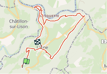
![](/images/other/stat-length.png)
![Randonnée Marche Lizine - lizine croix et lison - Photo](https://media.geolcdn.com/t/1900/400/89ebaf4b-099d-4372-ae6f-6f2d43eb6248.jpg&format=pjpeg&maxdim=2)
lizine croix et lison
eltonnermou
Utilisateur
![Longueur](/images/other/stat-length.png)
![Altitude max](https://static1.geolcdn.com/siteimages/upload/files/1508320355ic_sort_altitude_max_24dp.png)
![Dénivelé positif](https://static1.geolcdn.com/siteimages/upload/files/1508320355ic_sort_den_pos_24dp.png)
![Km-Effort](/images/other/stat-length.png)
![Altitude min](https://static1.geolcdn.com/siteimages/upload/files/1508320355ic_sort_altitude_min_24dp.png)
![Dénivelé négatif](https://static1.geolcdn.com/siteimages/upload/files/1508320355ic_sort_den_neg_24dp.png)
![Boucle](https://static1.geolcdn.com/siteimages/upload/files/16400158638029165_repeat_loop_refresh_sync_direction_icon.png)
![Marche](https://static1.geolcdn.com/sitytour/trail-icons/101.png)
4h25
Difficulté : Facile
![Scannez ce code QR pour ouvrir la randonnée dans l'application SityTrail](https://capi.geolives.com/qq0zvz2zws4bq2lad0pu/sitytour/trails/4025710/qr.png?size=200)
Application GPS de randonnée GRATUITE
À propos
Randonnée Marche de 12,3 km à découvrir à Bourgogne-Franche-Comté, Doubs, Lizine. Cette randonnée est proposée par eltonnermou.
Description
parking au centre de Lizine
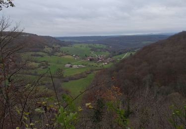
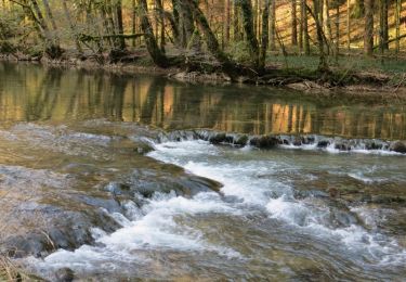
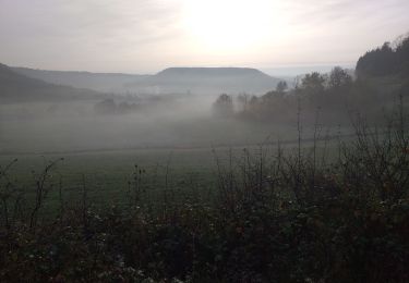
Très belle randonnée (malgré le trop d'asphalte, à mon goût) qui vous mène de belvédères en points de vue ; à ne pas faire par crue du Lison ; par une belle nature.
Avant de parvenir au dernier belvédère (gouille noire) admirez ce défilé entre les lapiaz, attention aux chevilles (surtout pour les enfants). Le belvédère de la Gouille noire, au plus profond du vallon, une cascade termine sa chute dans un trou d'eau: la Gouille noire. Le terme gouille, du germanique gullja, désigne une dépression remplie d'eau.
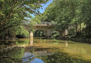
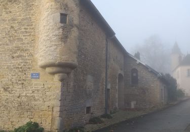
Sur le retour à Lizine profitez de ce bel étang (coin paisible), 200m avant Lizine, observez la jolie fontaine de Villevoz et ses bassins étagés construits en 1663, puis dans le centre un lavoir de 1884 et un oratoire du Dieu de pitié, élevé en 1668.
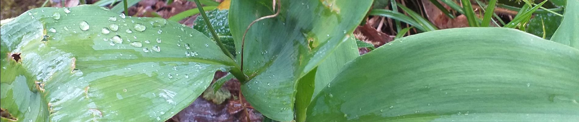
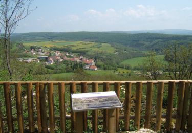
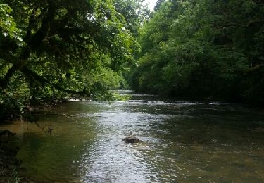
Continuez à profiter de cette belle nature et des nombreux points de vue.
Peut-être vous aurez la chance de voir : chamois ou autres animaux sauvages
Localisation
Commentaires
Randonnées à proximité
![Randonnée Marche Éternoz - Eternoz, lison - Photo](https://media.geolcdn.com/t/375/260/208ebe96-2cd0-48ef-ba00-81a5144b65f2.jpg&format=jpg&maxdim=2)
![Marche Marche](https://static1.geolcdn.com/sitytour/trail-icons/101.png)
Marche
![](/images/other/stat-length.png)
![](https://static1.geolcdn.com/siteimages/upload/files/16400158638029165_repeat_loop_refresh_sync_direction_icon.png)
![Randonnée Marche Échay - echay et ses belvédères - Photo](https://media.geolcdn.com/t/375/260/e9128b6b-1c37-4aeb-a422-222156e2fff2.jpg&format=jpg&maxdim=2)
![Marche Marche](https://static1.geolcdn.com/sitytour/trail-icons/101.png)
Marche
![](/images/other/stat-length.png)
![](https://static1.geolcdn.com/siteimages/upload/files/16400158638029165_repeat_loop_refresh_sync_direction_icon.png)
![Randonnée Marche Éternoz - Les Gorges du Lison - Eternoz - Photo](https://media.geolcdn.com/t/375/260/ext.jpg?maxdim=2&url=https%3A%2F%2Fservices.sitytrail.com%2FGeolivesWS%2FDownloadMedia.ashx%3FTrailID%3D317678%26Media%3D16971_2.jpg)
![Marche Marche](https://static1.geolcdn.com/sitytour/trail-icons/101.png)
Marche
![](/images/other/stat-length.png)
![](https://static1.geolcdn.com/siteimages/upload/files/16400158638029165_repeat_loop_refresh_sync_direction_icon.png)
![Randonnée Marche Cussey-sur-Lison - Les Belvédères du Lison - Doubs - Photo](https://media.geolcdn.com/t/375/260/ext.jpg?maxdim=2&url=https%3A%2F%2Fservices.sitytrail.com%2FGeolivesWS%2FDownloadMedia.ashx%3FTrailID%3D108921%26Media%3D2612_1.jpg)
![Marche Marche](https://static1.geolcdn.com/sitytour/trail-icons/101.png)
Marche
![](/images/other/stat-length.png)
![](https://static1.geolcdn.com/siteimages/upload/files/16400158638029165_repeat_loop_refresh_sync_direction_icon.png)
![Randonnée A pied Éternoz - Tour du Monniot - Photo](https://media.geolcdn.com/t/375/260/4f40bb2a-64fb-41b5-a821-5ab6a4ea7106.jpeg&format=jpg&maxdim=2)
![A pied A pied](https://static1.geolcdn.com/sitytour/trail-icons/100.png)
A pied
![](/images/other/stat-length.png)
![](https://static1.geolcdn.com/siteimages/upload/files/16400158638029165_repeat_loop_refresh_sync_direction_icon.png)
![Randonnée Marche Éternoz - eternoz belvédère chandelier - Photo](https://media.geolcdn.com/t/375/260/ext.jpg?maxdim=2&url=https%3A%2F%2Fservices.sitytrail.com%2FGeolivesWS%2FDownloadMedia.ashx%3FTrailID%3D310128%26Media%3Dfix__20140607143146.jpg)
![Marche Marche](https://static1.geolcdn.com/sitytour/trail-icons/101.png)
Marche
![](/images/other/stat-length.png)
![](https://static1.geolcdn.com/siteimages/upload/files/16400158638029165_repeat_loop_refresh_sync_direction_icon.png)
![Randonnée Marche Malans - bon an Malans - Photo](https://media.geolcdn.com/t/375/260/c8493cd4-41d2-4726-8c11-d8d25395d3a6.jpg&format=jpg&maxdim=2)
![Marche Marche](https://static1.geolcdn.com/sitytour/trail-icons/101.png)
Marche
![](/images/other/stat-length.png)
![](https://static1.geolcdn.com/siteimages/upload/files/16400158638029165_repeat_loop_refresh_sync_direction_icon.png)
![Randonnée Marche Myon - myon les lunettes à Stéphane - Photo](https://media.geolcdn.com/t/375/260/25acafcd-fd37-4522-a9e0-f3895665c873.jpg&format=jpg&maxdim=2)
![Marche Marche](https://static1.geolcdn.com/sitytour/trail-icons/101.png)
Marche
![](/images/other/stat-length.png)
![](https://static1.geolcdn.com/siteimages/upload/files/16400158638029165_repeat_loop_refresh_sync_direction_icon.png)
![Randonnée Marche Amondans - Amondans - Photo](https://media.geolcdn.com/t/375/260/4d00c8d3-fdc4-49de-aa75-bde7a160856b.jpg&format=jpg&maxdim=2)
![Marche Marche](https://static1.geolcdn.com/sitytour/trail-icons/101.png)
Marche
![](/images/other/stat-length.png)
![](https://static1.geolcdn.com/siteimages/upload/files/16400158638029165_repeat_loop_refresh_sync_direction_icon.png)