![](/images/other/stat-length.png)
![Randonnée Marche Pont-l'Abbé - Pont l'Abbé à Bénodet - Photo](https://media.geolcdn.com/t/1900/400/5b34e465-4bb1-4ce5-8012-1120e5f357da.jpg&format=pjpeg&maxdim=2)
Pont l'Abbé à Bénodet
Axelloceane
Utilisateur
![Longueur](/images/other/stat-length.png)
Longueur
23 km
![Altitude max](https://static1.geolcdn.com/siteimages/upload/files/1508320355ic_sort_altitude_max_24dp.png)
Altitude max
35 m
![Dénivelé positif](https://static1.geolcdn.com/siteimages/upload/files/1508320355ic_sort_den_pos_24dp.png)
Dénivelé positif
177 m
![Km-Effort](/images/other/stat-length.png)
Km-Effort
26 km
![Altitude min](https://static1.geolcdn.com/siteimages/upload/files/1508320355ic_sort_altitude_min_24dp.png)
Altitude min
-2 m
![Dénivelé négatif](https://static1.geolcdn.com/siteimages/upload/files/1508320355ic_sort_den_neg_24dp.png)
Dénivelé négatif
173 m
![Boucle](https://static1.geolcdn.com/siteimages/upload/files/16400158638029165_repeat_loop_refresh_sync_direction_icon.png)
Boucle
Non
Date de création :
2024-04-18 09:00:23.652
Dernière modification :
2024-04-22 18:59:59.297
![Marche](https://static1.geolcdn.com/sitytour/trail-icons/101.png)
4h59
Difficulté : Moyen
![Scannez ce code QR pour ouvrir la randonnée dans l'application SityTrail](https://capi.geolives.com/qq0zvz2zws4bq2lad0pu/sitytour/trails/4021565/qr.png?size=200)
Application GPS de randonnée GRATUITE
À propos
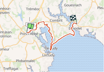
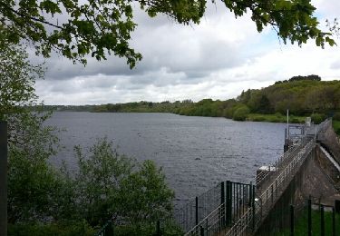
Randonnée Marche de 23 km à découvrir à Bretagne, Finistère, Pont-l'Abbé. Cette randonnée est proposée par Axelloceane.
Description
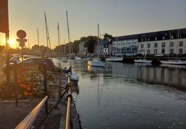
Départ de Pont l'Abbé destination Bénodet en suivant le balisage du GR 34 .A Sainte Marine possibilité de prendre le bac pour rejoindre Bénodet .
Localisation
Pays :
France
Région :
Bretagne
Département/Province :
Finistère
Commune :
Pont-l'Abbé
Localité :
Unknown
Départ:(Dec)
Départ:(UTM)
408310 ; 5302305 (30T) N.
Commentaires
Randonnées à proximité
![Randonnée Marche Plonéour-Lanvern - moulin neuf 2012-06-03 19h21m00 - Photo](https://media.geolcdn.com/t/375/260/ext.jpg?maxdim=2&url=https%3A%2F%2Fstatic1.geolcdn.com%2Fsiteimages%2Fupload%2Ffiles%2F1553511878bg_sport_marche.png)
![Marche Marche](https://static1.geolcdn.com/sitytour/trail-icons/101.png)
moulin neuf 2012-06-03 19h21m00
Marche
Très facile
(2)
Plonéour-Lanvern,
Bretagne,
Finistère,
France
![](/images/other/stat-length.png)
7,5 km | 8,3 km-effort
1h 42min
![](https://static1.geolcdn.com/siteimages/upload/files/16400158638029165_repeat_loop_refresh_sync_direction_icon.png)
Oui
![Randonnée Marche Pont-l'Abbé - GR34 Pont-l'Abbé -- Bénodet - Photo](https://media.geolcdn.com/t/375/260/a2ee19ef-481d-4c4e-92bc-5ffcf174dae8.jpg&format=jpg&maxdim=2)
![Marche Marche](https://static1.geolcdn.com/sitytour/trail-icons/101.png)
GR34 Pont-l'Abbé -- Bénodet
Marche
Moyen
Pont-l'Abbé,
Bretagne,
Finistère,
France
![](/images/other/stat-length.png)
27 km | 30 km-effort
6h 52min
![](https://static1.geolcdn.com/siteimages/upload/files/16400158638029165_repeat_loop_refresh_sync_direction_icon.png)
Non
![Randonnée A pied Plomeur - PLOMEUR - Photo](https://media.geolcdn.com/t/375/260/61520ad5-9a28-4010-847f-793b1c68649a.jpg&format=jpg&maxdim=2)
![A pied A pied](https://static1.geolcdn.com/sitytour/trail-icons/100.png)
![Randonnée Marche Pont-l'Abbé - PONT L'ABBÉ / LOCTUDY - Photo](https://media.geolcdn.com/t/375/260/a8f111bb-1728-4386-924e-5fa280bb0271.jpg&format=jpg&maxdim=2)
![Marche Marche](https://static1.geolcdn.com/sitytour/trail-icons/101.png)
PONT L'ABBÉ / LOCTUDY
Marche
Moyen
Pont-l'Abbé,
Bretagne,
Finistère,
France
![](/images/other/stat-length.png)
24 km | 26 km-effort
5h 46min
![](https://static1.geolcdn.com/siteimages/upload/files/16400158638029165_repeat_loop_refresh_sync_direction_icon.png)
Oui
![Randonnée sport Pont-l'Abbé - 2022-11-11_11h00m20_VTT1baseouestcornouaille2021osm - Photo](https://media.geolcdn.com/t/375/260/ext.jpg?maxdim=2&url=https%3A%2F%2Fsecurestorage.geolives.com%2Fsitytour%2Ftrail-bg%2Fdefault.jpg)
2022-11-11_11h00m20_VTT1baseouestcornouaille2021osm
sport
Très facile
(1)
Pont-l'Abbé,
Bretagne,
Finistère,
France
![](/images/other/stat-length.png)
35 km | 38 km-effort
Inconnu
![](https://static1.geolcdn.com/siteimages/upload/files/16400158638029165_repeat_loop_refresh_sync_direction_icon.png)
Oui
![Randonnée A pied Pont-l'Abbé - Le Chemin de Halage - Photo](https://media.geolcdn.com/t/375/260/7e5b068d-bfde-42f2-9d5d-4a5f426b9ab6.jpeg&format=jpg&maxdim=2)
![A pied A pied](https://static1.geolcdn.com/sitytour/trail-icons/100.png)
Le Chemin de Halage
A pied
Facile
Pont-l'Abbé,
Bretagne,
Finistère,
France
![](/images/other/stat-length.png)
4 km | 4,5 km-effort
1h 0min
![](https://static1.geolcdn.com/siteimages/upload/files/16400158638029165_repeat_loop_refresh_sync_direction_icon.png)
Non
![Randonnée Marche Pont-l'Abbé - Pont l'Abbé et l'estuaire de la rivière (fleuve côtier) du même nom - Photo](https://media.geolcdn.com/t/375/260/8391aaed-045d-4321-95a0-025816fd3624.jpg&format=jpg&maxdim=2)
![Marche Marche](https://static1.geolcdn.com/sitytour/trail-icons/101.png)
Pont l'Abbé et l'estuaire de la rivière (fleuve côtier) du même nom
Marche
Facile
Pont-l'Abbé,
Bretagne,
Finistère,
France
![](/images/other/stat-length.png)
15,2 km | 16,6 km-effort
5h 19min
![](https://static1.geolcdn.com/siteimages/upload/files/16400158638029165_repeat_loop_refresh_sync_direction_icon.png)
Non
![Randonnée Marche Pont-l'Abbé - PONT-L'ABBÉ - Photo](https://media.geolcdn.com/t/375/260/ext.jpg?maxdim=2&url=https%3A%2F%2Fservices.sitytrail.com%2FGeolivesWS%2FDownloadMedia.ashx%3FTrailID%3D1143640%26Media%3Dfix__20190421125638.jpg)
![Marche Marche](https://static1.geolcdn.com/sitytour/trail-icons/101.png)
![Randonnée Marche Plonéour-Lanvern - tour de l'étang du moulin neuf - Photo](https://media.geolcdn.com/t/375/260/ext.jpg?maxdim=2&url=https%3A%2F%2Fservices.sitytrail.com%2FGeolivesWS%2FDownloadMedia.ashx%3FTrailID%3D272561%26Media%3Dfix__20140501163232.jpg)
![Marche Marche](https://static1.geolcdn.com/sitytour/trail-icons/101.png)
tour de l'étang du moulin neuf
Marche
Facile
(1)
Plonéour-Lanvern,
Bretagne,
Finistère,
France
![](/images/other/stat-length.png)
7 km | 7,8 km-effort
1h 11min
![](https://static1.geolcdn.com/siteimages/upload/files/16400158638029165_repeat_loop_refresh_sync_direction_icon.png)
Oui