![](/images/other/stat-length.png)
![Randonnée Marche Trois-Ponts - RB-Lg-27_Trois-Ponts - Photo](https://media.geolcdn.com/t/1900/400/ext.pjpeg?maxdim=2&url=https%3A%2F%2Fservices.sitytrail.com%2FGeolivesWS%2FDownloadMedia.ashx%3FTrailID%3D402090%26Media%3Ddb9e80d9-8efc-4045-abb6-cee4f6885ea2.jpg)
RB-Lg-27_Trois-Ponts
GR Rando
Randonnez sur et autour des GR ® wallons (Sentiers de Grande Randonnée). PRO
![Longueur](/images/other/stat-length.png)
![Altitude max](https://static1.geolcdn.com/siteimages/upload/files/1508320355ic_sort_altitude_max_24dp.png)
![Dénivelé positif](https://static1.geolcdn.com/siteimages/upload/files/1508320355ic_sort_den_pos_24dp.png)
![Km-Effort](/images/other/stat-length.png)
![Altitude min](https://static1.geolcdn.com/siteimages/upload/files/1508320355ic_sort_altitude_min_24dp.png)
![Dénivelé négatif](https://static1.geolcdn.com/siteimages/upload/files/1508320355ic_sort_den_neg_24dp.png)
![Boucle](https://static1.geolcdn.com/siteimages/upload/files/16400158638029165_repeat_loop_refresh_sync_direction_icon.png)
![Marche](https://static1.geolcdn.com/sitytour/trail-icons/101.png)
7h30
Difficulté : Inconnu
![Scannez ce code QR pour ouvrir la randonnée dans l'application SityTrail](https://capi.geolives.com/qq0zvz2zws4bq2lad0pu/sitytour/trails/402090/qr.png?size=200)
Application GPS de randonnée GRATUITE
À propos
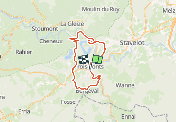
Randonnée Marche de 23 km à découvrir à Wallonie, Liège, Trois-Ponts. Cette randonnée est proposée par GR Rando.
Description
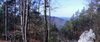
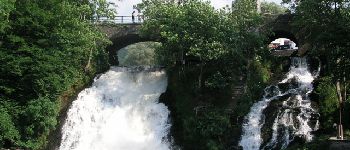
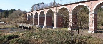
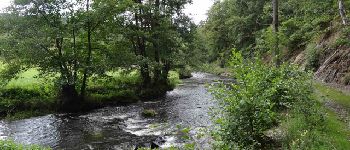
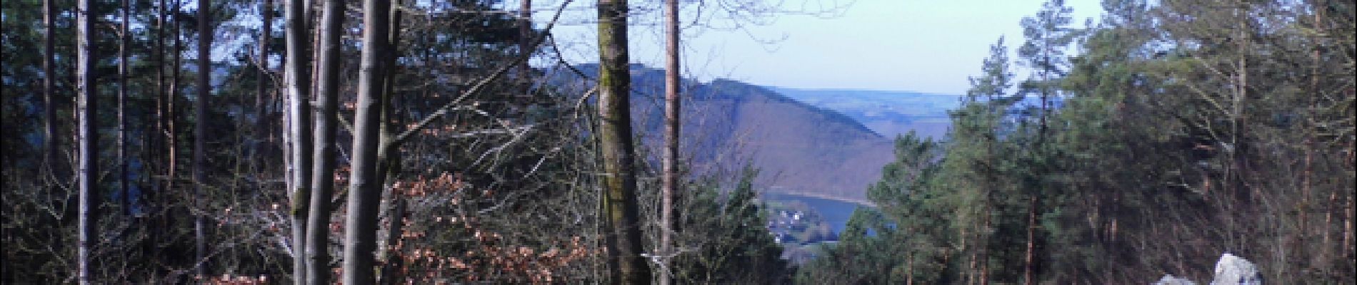
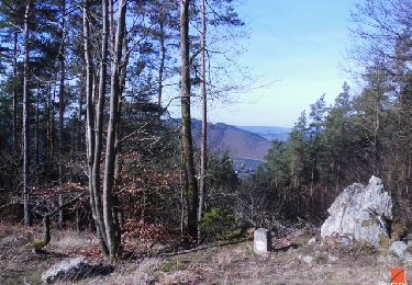
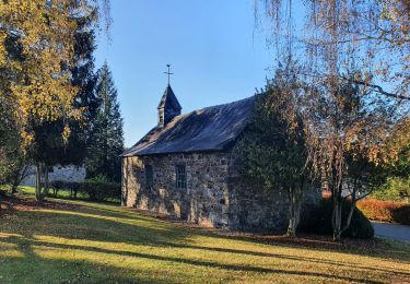
Les alentours de Trois-Ponts et de Coo sont essentiellement forestiers. Le relief accentué y met en exergue de nombreux panoramas ardennais. Au coeur de la nature, des vallons aux cours d’eau nerveux font la liaison avec des villages et hameaux typiques et paisibles.
Localisation
Commentaires
Randonnées à proximité
![Randonnée Marche Trois-Ponts - RB-Lg-29_Wanne - Photo](https://media.geolcdn.com/t/375/260/ext.jpg?maxdim=2&url=https%3A%2F%2Fservices.sitytrail.com%2FGeolivesWS%2FDownloadMedia.ashx%3FTrailID%3D402097%26Media%3Dd4589c74-2522-4a62-866b-b5d0038bf075.jpg)
![Marche Marche](https://static1.geolcdn.com/sitytour/trail-icons/101.png)
![Randonnée Marche Stoumont - RB-Lg-13_Stoumont - Photo](https://media.geolcdn.com/t/375/260/ext.jpg?maxdim=2&url=https%3A%2F%2Fservices.sitytrail.com%2FGeolivesWS%2FDownloadMedia.ashx%3FTrailID%3D179571%26Media%3Dfca3b0ca-06fe-45d6-8ded-857ea27270cf.jpg)
![Marche Marche](https://static1.geolcdn.com/sitytour/trail-icons/101.png)
Marche
![](/images/other/stat-length.png)
![](https://static1.geolcdn.com/siteimages/upload/files/16400158638029165_repeat_loop_refresh_sync_direction_icon.png)
![Randonnée Marche Stavelot - Extratrail_stavelot_13km_new - Photo](https://media.geolcdn.com/t/375/260/acb4a21b-3ac7-4958-9a44-c1358ae78040.jpg&format=jpg&maxdim=2)
![Marche Marche](https://static1.geolcdn.com/sitytour/trail-icons/101.png)
Marche
![](/images/other/stat-length.png)
![](https://static1.geolcdn.com/siteimages/upload/files/16400158638029165_repeat_loop_refresh_sync_direction_icon.png)
![Randonnée Marche Stoumont - La Gleize - P3 - Tour du Mont Saint-Victor - Photo](https://media.geolcdn.com/t/375/260/eeda461f-0b98-4912-915c-63b0e2025382.jpg&format=jpg&maxdim=2)
![Marche Marche](https://static1.geolcdn.com/sitytour/trail-icons/101.png)
Marche
![](/images/other/stat-length.png)
![](https://static1.geolcdn.com/siteimages/upload/files/16400158638029165_repeat_loop_refresh_sync_direction_icon.png)
![Randonnée Marche Stavelot - Stavelot - Photo](https://media.geolcdn.com/t/375/260/8b34c446-55a9-478c-88d7-9cb986b390fb.jpg&format=jpg&maxdim=2)
![Marche Marche](https://static1.geolcdn.com/sitytour/trail-icons/101.png)
Marche
![](/images/other/stat-length.png)
![](https://static1.geolcdn.com/siteimages/upload/files/16400158638029165_repeat_loop_refresh_sync_direction_icon.png)
![Randonnée Marche Trois-Ponts - RB-Lg-27_Trois-Ponts_via-racc - Photo](https://media.geolcdn.com/t/375/260/ext.jpg?maxdim=2&url=https%3A%2F%2Fservices.sitytrail.com%2FGeolivesWS%2FDownloadMedia.ashx%3FTrailID%3D402091%26Media%3Ddb9e80d9-8efc-4045-abb6-cee4f6885ea2.jpg)
![Marche Marche](https://static1.geolcdn.com/sitytour/trail-icons/101.png)
Marche
![](/images/other/stat-length.png)
![](https://static1.geolcdn.com/siteimages/upload/files/16400158638029165_repeat_loop_refresh_sync_direction_icon.png)
![Randonnée Marche Stavelot - Chemin des Sources |étape n°3 STAVELOT – HOCKAI - Photo](https://media.geolcdn.com/t/375/260/77791607-24fa-4b91-a259-1d28dbfa8616.jpg&format=jpg&maxdim=2)
![Marche Marche](https://static1.geolcdn.com/sitytour/trail-icons/101.png)
Marche
![](/images/other/stat-length.png)
![](https://static1.geolcdn.com/siteimages/upload/files/16400158638029165_repeat_loop_refresh_sync_direction_icon.png)
![Randonnée Marche Stoumont - stoumont . corniche - congo . chateau froidcourt . ambleve . stoumont - Photo](https://media.geolcdn.com/t/375/260/e9a69a2e-c189-4076-b755-49e5203b8455.jpg&format=jpg&maxdim=2)
![Marche Marche](https://static1.geolcdn.com/sitytour/trail-icons/101.png)
Marche
![](/images/other/stat-length.png)
![](https://static1.geolcdn.com/siteimages/upload/files/16400158638029165_repeat_loop_refresh_sync_direction_icon.png)
![Randonnée Marche Lierneux - rando reharmont 6/11/2020 - Photo](https://media.geolcdn.com/t/375/260/c172c759-425c-4a1d-95a3-aaadcf59b477.jpg&format=jpg&maxdim=2)
![Marche Marche](https://static1.geolcdn.com/sitytour/trail-icons/101.png)
Marche
![](/images/other/stat-length.png)
![](https://static1.geolcdn.com/siteimages/upload/files/16400158638029165_repeat_loop_refresh_sync_direction_icon.png)
On aimerait plus de photos de cette très belle région
Abomination Coo
un peu trop de route par moments
Très beau parcours