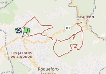
![](/images/other/stat-length.png)
![Randonnée A pied Roquefort-les-Pins - Roquefort les Pins, Castellas et Borie - Photo](https://media.geolcdn.com/t/1900/400/ext.pjpeg?maxdim=2&url=https%3A%2F%2Fstatic1.geolcdn.com%2Fsiteimages%2Fupload%2Ffiles%2F1545311037marcheuse_200dpi.jpg)
Roquefort les Pins, Castellas et Borie
Renefrt
Utilisateur
![Longueur](/images/other/stat-length.png)
![Altitude max](https://static1.geolcdn.com/siteimages/upload/files/1508320355ic_sort_altitude_max_24dp.png)
![Dénivelé positif](https://static1.geolcdn.com/siteimages/upload/files/1508320355ic_sort_den_pos_24dp.png)
![Km-Effort](/images/other/stat-length.png)
![Altitude min](https://static1.geolcdn.com/siteimages/upload/files/1508320355ic_sort_altitude_min_24dp.png)
![Dénivelé négatif](https://static1.geolcdn.com/siteimages/upload/files/1508320355ic_sort_den_neg_24dp.png)
![Boucle](https://static1.geolcdn.com/siteimages/upload/files/16400158638029165_repeat_loop_refresh_sync_direction_icon.png)
![A pied](https://static1.geolcdn.com/sitytour/trail-icons/100.png)
4h20
Difficulté : Facile
![Scannez ce code QR pour ouvrir la randonnée dans l'application SityTrail](https://capi.geolives.com/qq0zvz2zws4bq2lad0pu/sitytour/trails/4017724/qr.png?size=200)
Application GPS de randonnée GRATUITE
À propos
Randonnée A pied de 14,3 km à découvrir à Provence-Alpes-Côte d'Azur, Alpes-Maritimes, Roquefort-les-Pins. Cette randonnée est proposée par Renefrt.
Description
Le Debran, Roquefort les Pins ( Alpes-Maritimes 06 )
Parking possible on-rend le chemin à gauche,
un petite détour pour voir au milieu de ruines un four, puis on prend à droite un chemin vers le camp romain "Tracier", murs d'enceinte,
restes de murs envahis par la végétation (se repérer sous la ligne électrique moyenne tension),
La grotte de la Chèvre d'or que l'on peut visiter (avec lampe).
Retour sur la piste descente vers la route D7 et prise à droite d'un chemin qui monte aux ruines du Castellas (ruines du château, et de l'église st Michel),
tour sur la piste que l'on va suivre vers le Borie et le parking.
Localisation
Commentaires
Randonnées à proximité
![Randonnée Marche Tourrettes-sur-Loup - Le Puy de Naouri 1024 m, depuis Tourrettes-sur-Loup - Photo](https://media.geolcdn.com/t/375/260/ext.jpg?maxdim=2&url=https%3A%2F%2Fservices.sitytrail.com%2FGeolivesWS%2FDownloadMedia.ashx%3FTrailID%3D214858%26Media%3D15396_1.jpg)
![Marche Marche](https://static1.geolcdn.com/sitytour/trail-icons/101.png)
Marche
![](/images/other/stat-length.png)
![](https://static1.geolcdn.com/siteimages/upload/files/16400158638029165_repeat_loop_refresh_sync_direction_icon.png)
![Randonnée Marche Tourrettes-sur-Loup - Tourettes-sur loup Pic Courmettes Puys Tourettes et Naouri Trace réélle - Photo](https://media.geolcdn.com/t/375/260/f748dbe0-f767-4ec6-adb2-ccba5818c44e.jpg&format=jpg&maxdim=2)
![Marche Marche](https://static1.geolcdn.com/sitytour/trail-icons/101.png)
Marche
![](/images/other/stat-length.png)
![](https://static1.geolcdn.com/siteimages/upload/files/16400158638029165_repeat_loop_refresh_sync_direction_icon.png)
![Randonnée Marche Le Bar-sur-Loup - Le Bar sur Loup Gourdon Barre et plateau de Cavillore réel - Photo](https://media.geolcdn.com/t/375/260/c167fd77-8053-444f-a9c7-0c602a316e76.jpg&format=jpg&maxdim=2)
![Marche Marche](https://static1.geolcdn.com/sitytour/trail-icons/101.png)
Marche
![](/images/other/stat-length.png)
![](https://static1.geolcdn.com/siteimages/upload/files/16400158638029165_repeat_loop_refresh_sync_direction_icon.png)
![Randonnée A pied Tourrettes-sur-Loup - Circuit de Pié Martin - Photo](https://media.geolcdn.com/t/375/260/6e40e7c0-6b09-4a1a-a532-91e02b70ea94.jpeg&format=jpg&maxdim=2)
![A pied A pied](https://static1.geolcdn.com/sitytour/trail-icons/100.png)
A pied
![](/images/other/stat-length.png)
![](https://static1.geolcdn.com/siteimages/upload/files/16400158638029165_repeat_loop_refresh_sync_direction_icon.png)
![Randonnée A pied Le Rouret - Le Camp romain - Photo](https://media.geolcdn.com/t/375/260/d6aefa76-dc44-4fc7-8d77-d19148310732.jpeg&format=jpg&maxdim=2)
![A pied A pied](https://static1.geolcdn.com/sitytour/trail-icons/100.png)
A pied
![](/images/other/stat-length.png)
![](https://static1.geolcdn.com/siteimages/upload/files/16400158638029165_repeat_loop_refresh_sync_direction_icon.png)
![Randonnée A pied Le Bar-sur-Loup - Circuit du Paradis - Photo](https://media.geolcdn.com/t/375/260/c599f589-6942-4b9f-bfea-287eb9516c31.jpeg&format=jpg&maxdim=2)
![A pied A pied](https://static1.geolcdn.com/sitytour/trail-icons/100.png)
A pied
![](/images/other/stat-length.png)
![](https://static1.geolcdn.com/siteimages/upload/files/16400158638029165_repeat_loop_refresh_sync_direction_icon.png)
![Randonnée A pied Gourdon - Plateau de Cavillore - Photo](https://media.geolcdn.com/t/375/260/094c0018-0a4d-4f34-8879-15bc82519f15.jpeg&format=jpg&maxdim=2)
![A pied A pied](https://static1.geolcdn.com/sitytour/trail-icons/100.png)
A pied
![](/images/other/stat-length.png)
![](https://static1.geolcdn.com/siteimages/upload/files/16400158638029165_repeat_loop_refresh_sync_direction_icon.png)
![Randonnée A pied Tourrettes-sur-Loup - Puy de Naouri - Photo](https://media.geolcdn.com/t/375/260/a11b075b-d314-4d7d-9ea3-2c9f013025ba.jpeg&format=jpg&maxdim=2)
![A pied A pied](https://static1.geolcdn.com/sitytour/trail-icons/100.png)
A pied
![](/images/other/stat-length.png)
![](https://static1.geolcdn.com/siteimages/upload/files/16400158638029165_repeat_loop_refresh_sync_direction_icon.png)
![Randonnée A pied Roquefort-les-Pins - Le Rucher - Photo](https://media.geolcdn.com/t/375/260/8984dec4-46ee-4507-9355-103df05628e2.jpeg&format=jpg&maxdim=2)
![A pied A pied](https://static1.geolcdn.com/sitytour/trail-icons/100.png)
A pied
![](/images/other/stat-length.png)
![](https://static1.geolcdn.com/siteimages/upload/files/16400158638029165_repeat_loop_refresh_sync_direction_icon.png)