Randonnée A pied Nanteau-sur-Essonne - Nanteau-sur-Essonne - Le Malesherbois - Buthiers - Photo

Nanteau-sur-Essonne - Le Malesherbois - Buthiers

 mathis01
mathis01

Utilisateur

© OpenStreetMap contributors
Longueur
Longueur
14,9 km
Altitude max
Altitude max
122 m
Dénivelé positif
Dénivelé positif
225 m
Km-Effort
Km-Effort  
17,9 km
Altitude min
Altitude min
69 m
Dénivelé négatif
Dénivelé négatif
224 m
Boucle
Boucle
Oui
Date de création :
2024-04-15 13:11:41.714
Dernière modification :
2024-07-21 08:59:32.847

(0 Avis)

A pied
A pied
4h03
Difficulté : Facile

Scannez ce code QR pour ouvrir la randonnée dans l'application SityTrail

Application GPS de randonnée GRATUITE

Logo SityTrail SityTrail

IGN / Instituts géographiques

Télécharger SityTrail sur l'App Store Télécharger SityTrail sur Google Play

Logo SityTrail SityTrail World

Le monde est à vous

Télécharger SityTrail sur l'App Store Télécharger SityTrail sur Google Play Télécharger SityTrail sur Huawei AppGallery

À propos

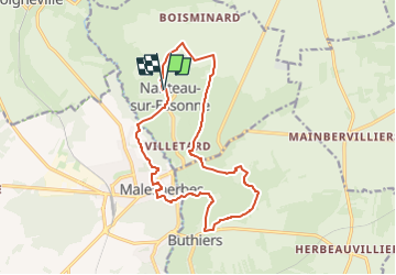
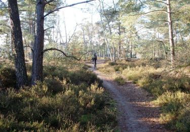
Randonnée A pied de 14,9 km à découvrir à Île-de-France, Seine-et-Marne, Nanteau-sur-Essonne. Cette randonnée est proposée par mathis01.

Profil altimétrique

Localisation

Pays :
France
Région :
Île-de-France
Département/Province :
Seine-et-Marne
Commune :
Nanteau-sur-Essonne
Localité :
Unknown
Départ:(UTM)
456821 ; 5351579 (31U) N.

Randonnées à proximité

Randonnée Marche Le Malesherbois - Le tour du Grand Paris via le GR1 étape 15 Malesherbes- Boutigny sur Essonne - Photo
Marche
GUIDE
chessyca

Marche

Facile
Le Malesherbois, Centre-Val de Loire, Loiret, France
28 km | 33 km-effort
5h 58min
Non
Randonnée Marche Buno-Bonnevaux - Buno-Bonneveaux - Polissoir de Grimery - Photo
Marche
guydu41

Marche

Moyen
Buno-Bonnevaux, Île-de-France, Essonne, France
7,5 km | 8,9 km-effort
2h 0min
Oui
Randonnée Marche Buno-Bonnevaux - Buneau-Bonnevaux Menhir de la pierre droite  - Photo
Marche
jll7513

Marche

Facile
Buno-Bonnevaux, Île-de-France, Essonne, France
12,2 km | 13,9 km-effort
3h 9min
Oui
Randonnée V.T.T. Buthiers - Enduro VTT de Buthiers 2006 - Photo
V.T.T.
tracegps

V.T.T.

Très difficile
Buthiers, Île-de-France, Seine-et-Marne, France
36 km | 44 km-effort
3h 0min
Oui
Randonnée V.T.T. Prunay-sur-Essonne - VTT 25 juin 2024 - Photo
V.T.T.
poozix

V.T.T.

Facile
Prunay-sur-Essonne, Île-de-France, Essonne, France
13 km | 14,3 km-effort
1h 32min
Oui
Randonnée Canoë - kayak Prunay-sur-Essonne - 16 jun 2024 - Photo
Canoë - kayak
poozix

Canoë - kayak

Très facile
Prunay-sur-Essonne, Île-de-France, Essonne, France
10,9 km | 12,1 km-effort
51min
Oui
Randonnée V.T.T. Prunay-sur-Essonne - 17 oct 2923  - Photo
V.T.T.
poozix

V.T.T.

Très facile
Prunay-sur-Essonne, Île-de-France, Essonne, France
13,4 km | 15 km-effort
1h 31min
Oui
Randonnée V.T.T. Prunay-sur-Essonne - VTT 26 juin 2023 - Photo
V.T.T.
poozix

V.T.T.

Moyen
Prunay-sur-Essonne, Île-de-France, Essonne, France
18,9 km | 21 km-effort
2h 10min
Oui
Randonnée Marche Boigneville - Boigneville - Photo
Marche
JacquesMARQUET

Marche

Difficile
Boigneville, Île-de-France, Essonne, France
12,9 km | 14,8 km-effort
3h 17min
Oui


Fermer
Mes abonnements