![](/images/other/stat-length.png)
![Randonnée Marche Stein am Rhein - YHH141 Stein am Rhein à Steckborn - Photo](https://media.geolcdn.com/t/1900/400/ext.pjpeg?maxdim=2&url=https%3A%2F%2Fstatic1.geolcdn.com%2Fsiteimages%2Fupload%2Ffiles%2F1553511878bg_sport_marche.png)
YHH141 Stein am Rhein à Steckborn
yveshumbert
Utilisateur
![Longueur](/images/other/stat-length.png)
Longueur
15,3 km
![Altitude max](https://static1.geolcdn.com/siteimages/upload/files/1508320355ic_sort_altitude_max_24dp.png)
Altitude max
601 m
![Dénivelé positif](https://static1.geolcdn.com/siteimages/upload/files/1508320355ic_sort_den_pos_24dp.png)
Dénivelé positif
456 m
![Km-Effort](/images/other/stat-length.png)
Km-Effort
21 km
![Altitude min](https://static1.geolcdn.com/siteimages/upload/files/1508320355ic_sort_altitude_min_24dp.png)
Altitude min
392 m
![Dénivelé négatif](https://static1.geolcdn.com/siteimages/upload/files/1508320355ic_sort_den_neg_24dp.png)
Dénivelé négatif
468 m
![Boucle](https://static1.geolcdn.com/siteimages/upload/files/16400158638029165_repeat_loop_refresh_sync_direction_icon.png)
Boucle
Non
Date de création :
2015-08-24 00:00:00.0
Dernière modification :
2015-08-24 00:00:00.0
![Marche](https://static1.geolcdn.com/sitytour/trail-icons/101.png)
4h15
Difficulté : Moyen
![Scannez ce code QR pour ouvrir la randonnée dans l'application SityTrail](https://capi.geolives.com/qq0zvz2zws4bq2lad0pu/sitytour/trails/401593/qr.png?size=200)
Application GPS de randonnée GRATUITE
À propos
Randonnée Marche de 15,3 km à découvrir à Schaffhouse, Inconnu, Stein am Rhein. Cette randonnée est proposée par yveshumbert.
Description
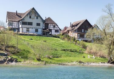
Randonnée de 5 étapes le long du Rhin (Via Rhenana) au départ de Elisau et arrivée à Kreuzlingen. Etape # 4 Stein am Rhein à Steckborn
Localisation
Pays :
Suisse
Région :
Schaffhouse
Département/Province :
Inconnu
Commune :
Stein am Rhein
Localité :
Unknown
Départ:(Dec)
Départ:(UTM)
489196 ; 5278174 (32T) N.
Commentaires
Randonnées à proximité
![Randonnée A pied Stein am Rhein - Uferrundweg Stein am Rhein - Photo](https://media.geolcdn.com/t/375/260/e513e5c3-8da9-4e7e-82ec-d18cb65fa8f7.jpeg&format=jpg&maxdim=2)
![A pied A pied](https://static1.geolcdn.com/sitytour/trail-icons/100.png)
Uferrundweg Stein am Rhein
A pied
Facile
Stein am Rhein,
Schaffhouse,
Inconnu,
Suisse
![](/images/other/stat-length.png)
6,5 km | 7,6 km-effort
1h 44min
![](https://static1.geolcdn.com/siteimages/upload/files/16400158638029165_repeat_loop_refresh_sync_direction_icon.png)
Oui
![Randonnée Vélo Stein am Rhein - bdr12_dRamsen - Photo](https://media.geolcdn.com/t/375/260/ext.jpg?maxdim=2&url=https%3A%2F%2Fstatic1.geolcdn.com%2Fsiteimages%2Fupload%2Ffiles%2F1524743154velo.jpg)
![Vélo Vélo](https://static1.geolcdn.com/sitytour/trail-icons/200.png)
bdr12_dRamsen
Vélo
Très facile
Stein am Rhein,
Schaffhouse,
Inconnu,
Suisse
![](/images/other/stat-length.png)
36 km | 48 km-effort
1h 52min
![](https://static1.geolcdn.com/siteimages/upload/files/16400158638029165_repeat_loop_refresh_sync_direction_icon.png)
Non
![Randonnée Autre activité Öhningen - bdr12_Stein_SH - Photo](https://media.geolcdn.com/t/375/260/ext.jpg?maxdim=2&url=https%3A%2F%2Fstatic1.geolcdn.com%2Fsiteimages%2Fupload%2Ffiles%2F1545311037marcheuse_200dpi.jpg)
![Autre activité Autre activité](https://static1.geolcdn.com/sitytour/trail-icons/900.png)
bdr12_Stein_SH
Autre activité
Très facile
Öhningen,
Bade-Wurtemberg,
Landkreis Konstanz,
Allemagne
![](/images/other/stat-length.png)
141 km | 197 km-effort
43h 36min
![](https://static1.geolcdn.com/siteimages/upload/files/16400158638029165_repeat_loop_refresh_sync_direction_icon.png)
Non
![Randonnée Autre activité Eschenz - xxx11_Bodensee_Stein - Photo](https://media.geolcdn.com/t/375/260/ext.jpg?maxdim=2&url=https%3A%2F%2Fstatic1.geolcdn.com%2Fsiteimages%2Fupload%2Ffiles%2F1545311037marcheuse_200dpi.jpg)
![Autre activité Autre activité](https://static1.geolcdn.com/sitytour/trail-icons/900.png)
xxx11_Bodensee_Stein
Autre activité
Très facile
Eschenz,
Thurgovie,
Bezirk Frauenfeld,
Suisse
![](/images/other/stat-length.png)
66 km | 67 km-effort
15h 6min
![](https://static1.geolcdn.com/siteimages/upload/files/16400158638029165_repeat_loop_refresh_sync_direction_icon.png)
Non
![Randonnée Cyclotourisme Stein am Rhein - Stein Am Rhein - Singen (par les chuttes du Rhin) - Photo](https://media.geolcdn.com/t/375/260/ext.jpg?maxdim=2&url=https%3A%2F%2Fstatic1.geolcdn.com%2Fsiteimages%2Fupload%2Ffiles%2F1524743154velo.jpg)
![Cyclotourisme Cyclotourisme](https://static1.geolcdn.com/sitytour/trail-icons/204.png)
Stein Am Rhein - Singen (par les chuttes du Rhin)
Cyclotourisme
Très facile
Stein am Rhein,
Schaffhouse,
Inconnu,
Suisse
![](/images/other/stat-length.png)
79 km | 90 km-effort
Inconnu
![](https://static1.geolcdn.com/siteimages/upload/files/16400158638029165_repeat_loop_refresh_sync_direction_icon.png)
Non
![Randonnée V.T.C. Stein am Rhein - Stein am Rhein – Dingelsdorf - Singen - Photo](https://media.geolcdn.com/t/375/260/ext.jpg?maxdim=2&url=https%3A%2F%2Fstatic1.geolcdn.com%2Fsiteimages%2Fupload%2Ffiles%2F1524743154velo.jpg)
![V.T.C. V.T.C.](https://static1.geolcdn.com/sitytour/trail-icons/203.png)
Stein am Rhein – Dingelsdorf - Singen
V.T.C.
Très facile
Stein am Rhein,
Schaffhouse,
Inconnu,
Suisse
![](/images/other/stat-length.png)
86 km | 98 km-effort
Inconnu
![](https://static1.geolcdn.com/siteimages/upload/files/16400158638029165_repeat_loop_refresh_sync_direction_icon.png)
Non
![Randonnée Marche Stein am Rhein - Klingenzell TG - Sieben Schmerzen Mariä - Photo](https://media.geolcdn.com/t/375/260/ext.jpg?maxdim=2&url=https%3A%2F%2Fstatic1.geolcdn.com%2Fsiteimages%2Fupload%2Ffiles%2F1553511878bg_sport_marche.png)
![Marche Marche](https://static1.geolcdn.com/sitytour/trail-icons/101.png)
Klingenzell TG - Sieben Schmerzen Mariä
Marche
Très facile
Stein am Rhein,
Schaffhouse,
Inconnu,
Suisse
![](/images/other/stat-length.png)
11,7 km | 15,6 km-effort
3h 31min
![](https://static1.geolcdn.com/siteimages/upload/files/16400158638029165_repeat_loop_refresh_sync_direction_icon.png)
Oui
![Randonnée sport Eschenz - 3 - Photo](https://media.geolcdn.com/t/375/260/ext.jpg?maxdim=2&url=https%3A%2F%2Fsecurestorage.geolives.com%2Fsitytour%2Ftrail-bg%2Fdefault.jpg)
3
sport
Très facile
Eschenz,
Thurgovie,
Bezirk Frauenfeld,
Suisse
![](/images/other/stat-length.png)
4,2 km | 4,7 km-effort
Inconnu
![](https://static1.geolcdn.com/siteimages/upload/files/16400158638029165_repeat_loop_refresh_sync_direction_icon.png)
Non
![Randonnée Cyclotourisme Mammern - 10 ème étape - Photo](https://media.geolcdn.com/t/375/260/ext.jpg?maxdim=2&url=https%3A%2F%2Fstatic1.geolcdn.com%2Fsiteimages%2Fupload%2Ffiles%2F1524743154velo.jpg)
![Cyclotourisme Cyclotourisme](https://static1.geolcdn.com/sitytour/trail-icons/204.png)
10 ème étape
Cyclotourisme
Très difficile
Mammern,
Thurgovie,
Bezirk Frauenfeld,
Suisse
![](/images/other/stat-length.png)
55 km | 64 km-effort
4h 31min
![](https://static1.geolcdn.com/siteimages/upload/files/16400158638029165_repeat_loop_refresh_sync_direction_icon.png)
Non