Randonnée Marche Avesnes-le-Comte - Avesnes - Photo
 Pascal Raon
Pascal Raon

Utilisateur

© OpenStreetMap contributors
Longueur
Longueur
943 m
Altitude max
Altitude max
137 m
Dénivelé positif
Dénivelé positif
7 m
Km-Effort
Km-Effort  
1 km
Altitude min
Altitude min
128 m
Dénivelé négatif
Dénivelé négatif
0 m
Boucle
Boucle
Non
Date de création :
2024-04-12 15:04:21.469
Dernière modification :
2024-04-12 15:19:16.187

(0 Avis)

Marche
Marche
14m
Difficulté : Facile

Scannez ce code QR pour ouvrir la randonnée dans l'application SityTrail

Application GPS de randonnée GRATUITE

Logo SityTrail SityTrail

IGN / Instituts géographiques

Télécharger SityTrail sur l'App Store Télécharger SityTrail sur Google Play

Logo SityTrail SityTrail World

Le monde est à vous

Télécharger SityTrail sur l'App Store Télécharger SityTrail sur Google Play Télécharger SityTrail sur Huawei AppGallery

À propos

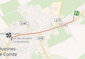
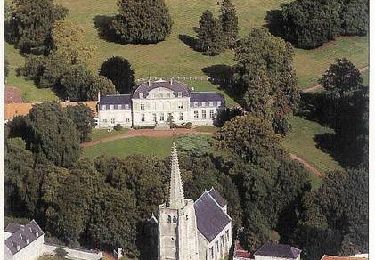
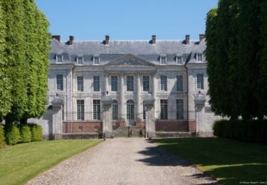
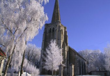
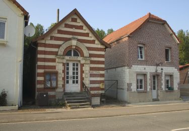
Randonnée Marche de 943 m à découvrir à Hauts-de-France, Pas-de-Calais, Avesnes-le-Comte. Cette randonnée est proposée par Pascal Raon.

Profil altimétrique

Localisation

Pays :
France
Région :
Hauts-de-France
Département/Province :
Pas-de-Calais
Commune :
Avesnes-le-Comte
Localité :
Unknown
Départ:(Dec)
Départ:(UTM)
467203 ; 5569871 (31U) N.

Randonnées à proximité

Randonnée V.T.T. Avesnes-le-Comte - Les 6 châteaux - Avesnes le Comte - Photo
V.T.T.
tracegps

V.T.T.

Difficile
(1)
Avesnes-le-Comte, Hauts-de-France, Pas-de-Calais, France
44 km | 50 km-effort
2h 10min
Oui
Randonnée V.T.T. Fosseux - Lucheux - Photo
V.T.T.
tracegps

V.T.T.

Moyen
(2)
Fosseux, Hauts-de-France, Pas-de-Calais, France
44 km | 50 km-effort
3h 0min
Oui
Randonnée Marche Lignereuil - LIGNEREUIL (62) - Par le bois du Fay - Photo
Marche
temmichel

Marche

Difficile
Lignereuil, Hauts-de-France, Pas-de-Calais, France
12,1 km | 13,5 km-effort
3h 4min
Oui
Randonnée Marche Avesnes-le-Comte - Avesnes le Comte, Noyelle-Vion, Manin, Beaufort-Blavincourt - Photo
Marche
tracegps

Marche

Moyen
Avesnes-le-Comte, Hauts-de-France, Pas-de-Calais, France
10,8 km | 12,2 km-effort
2h 30min
Oui
Randonnée Marche Hermaville - Chemin de la vertu bleue (Hermanville) - Photo
Marche
tracegps

Marche

Moyen
Hermaville, Hauts-de-France, Pas-de-Calais, France
11,1 km | 12,9 km-effort
2h 49min
Oui
Randonnée Marche Hermaville - Circuit des porches - Hermaville - Photo
Marche
tracegps

Marche

Facile
Hermaville, Hauts-de-France, Pas-de-Calais, France
1,9 km | 2,1 km-effort
1h 0min
Oui
Randonnée Marche Hauteville - Randonnée autour de Hauteville - Barly - Fosseux - Photo
Marche
tracegps

Marche

Moyen
Hauteville, Hauts-de-France, Pas-de-Calais, France
10,4 km | 11,8 km-effort
2h 0min
Oui
Randonnée Marche Hermaville - Hermaville - Izel le Hameau - Tilloy les Hermaville - Photo
Marche
tracegps

Marche

Moyen
Hermaville, Hauts-de-France, Pas-de-Calais, France
10,7 km | 11,7 km-effort
2h 30min
Oui
Randonnée Marche Hermaville -  Hermaville - Berles Monchel - Tilloy les Hermavile - Photo
Marche
tracegps

Marche

Moyen
Hermaville, Hauts-de-France, Pas-de-Calais, France
10 km | 11,3 km-effort
2h 0min
Oui


Fermer
Mes abonnements