![](/images/other/stat-length.png)
![Randonnée Marche Corrençon-en-Vercors - Corrençon en Vercors (le 45E parallèle) - Photo](https://media.geolcdn.com/t/1900/400/100e789c-dd10-4bd6-a7ef-d0f6c0d62005.jpg&format=pjpeg&maxdim=2)
Corrençon en Vercors (le 45E parallèle)
ISATR
Utilisateur
![Longueur](/images/other/stat-length.png)
Longueur
10,8 km
![Altitude max](https://static1.geolcdn.com/siteimages/upload/files/1508320355ic_sort_altitude_max_24dp.png)
Altitude max
1315 m
![Dénivelé positif](https://static1.geolcdn.com/siteimages/upload/files/1508320355ic_sort_den_pos_24dp.png)
Dénivelé positif
248 m
![Km-Effort](/images/other/stat-length.png)
Km-Effort
14,1 km
![Altitude min](https://static1.geolcdn.com/siteimages/upload/files/1508320355ic_sort_altitude_min_24dp.png)
Altitude min
1100 m
![Dénivelé négatif](https://static1.geolcdn.com/siteimages/upload/files/1508320355ic_sort_den_neg_24dp.png)
Dénivelé négatif
247 m
![Boucle](https://static1.geolcdn.com/siteimages/upload/files/16400158638029165_repeat_loop_refresh_sync_direction_icon.png)
Boucle
Oui
Date de création :
2024-04-12 08:58:47.784
Dernière modification :
2024-04-16 16:47:24.366
![Marche](https://static1.geolcdn.com/sitytour/trail-icons/101.png)
3h22
Difficulté : Moyen
![Scannez ce code QR pour ouvrir la randonnée dans l'application SityTrail](https://capi.geolives.com/qq0zvz2zws4bq2lad0pu/sitytour/trails/4013740/qr.png?size=200)
Application GPS de randonnée GRATUITE
À propos
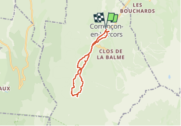
Randonnée Marche de 10,8 km à découvrir à Auvergne-Rhône-Alpes, Isère, Corrençon-en-Vercors. Cette randonnée est proposée par ISATR.
Description
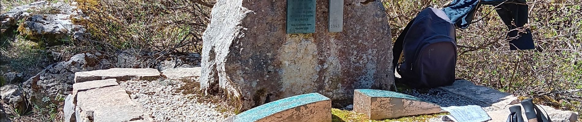
Monument érigé en l'honneur de la résistance en Vercors et lieu de passage du 45ème parallèle.
Stade de biathlon.
Localisation
Pays :
France
Région :
Auvergne-Rhône-Alpes
Département/Province :
Isère
Commune :
Corrençon-en-Vercors
Localité :
Unknown
Départ:(Dec)
Départ:(UTM)
699049 ; 4989656 (31T) N.
Commentaires
Randonnées à proximité
![Randonnée Marche Villard-de-Lans - villard col des 2 soeurs - Photo](https://media.geolcdn.com/t/375/260/ext.jpg?maxdim=2&url=https%3A%2F%2Fservices.sitytrail.com%2FGeolivesWS%2FDownloadMedia.ashx%3FTrailID%3D453991%26Media%3Dfix__20150803124330.jpg)
![Marche Marche](https://static1.geolcdn.com/sitytour/trail-icons/101.png)
villard col des 2 soeurs
Marche
Moyen
(1)
Villard-de-Lans,
Auvergne-Rhône-Alpes,
Isère,
France
![](/images/other/stat-length.png)
7,7 km | 13,8 km-effort
2h 45min
![](https://static1.geolcdn.com/siteimages/upload/files/16400158638029165_repeat_loop_refresh_sync_direction_icon.png)
Oui
![Randonnée Marche Villard-de-Lans - cabane de robon - Photo](https://media.geolcdn.com/t/375/260/f81b29b4-5a6d-4db9-85aa-f42275b30a70.jpg&format=jpg&maxdim=2)
![Marche Marche](https://static1.geolcdn.com/sitytour/trail-icons/101.png)
cabane de robon
Marche
Très facile
(1)
Villard-de-Lans,
Auvergne-Rhône-Alpes,
Isère,
France
![](/images/other/stat-length.png)
10,2 km | 15,8 km-effort
5h 25min
![](https://static1.geolcdn.com/siteimages/upload/files/16400158638029165_repeat_loop_refresh_sync_direction_icon.png)
Oui
![Randonnée V.T.T. Corrençon-en-Vercors - Grande Traversée des PréAlpes à VTT : Corrençon en Vercors - La Chapelle en Vercors - Photo](https://media.geolcdn.com/t/375/260/ext.jpg?maxdim=2&url=https%3A%2F%2Fservices.sitytrail.com%2FGeolivesWS%2FDownloadMedia.ashx%3FTrailID%3D102135%26Media%3D2525_2.jpg)
![V.T.T. V.T.T.](https://static1.geolcdn.com/sitytour/trail-icons/202.png)
Grande Traversée des PréAlpes à VTT : Corrençon en Vercors - La Chapelle en V...
V.T.T.
Difficile
(1)
Corrençon-en-Vercors,
Auvergne-Rhône-Alpes,
Isère,
France
![](/images/other/stat-length.png)
25 km | 36 km-effort
3h 30min
![](https://static1.geolcdn.com/siteimages/upload/files/16400158638029165_repeat_loop_refresh_sync_direction_icon.png)
Non
![Randonnée Marche Villard-de-Lans - Le sentier Peronnard et le Pas de l'OEille - Photo](https://media.geolcdn.com/t/375/260/ext.jpg?maxdim=2&url=https%3A%2F%2Fservices.sitytrail.com%2FGeolivesWS%2FDownloadMedia.ashx%3FTrailID%3D101509%26Media%3D1614_1.jpg)
![Marche Marche](https://static1.geolcdn.com/sitytour/trail-icons/101.png)
Le sentier Peronnard et le Pas de l'OEille
Marche
Facile
(1)
Villard-de-Lans,
Auvergne-Rhône-Alpes,
Isère,
France
![](/images/other/stat-length.png)
13,7 km | 25 km-effort
6h 0min
![](https://static1.geolcdn.com/siteimages/upload/files/16400158638029165_repeat_loop_refresh_sync_direction_icon.png)
Oui
![Randonnée Marche Villard-de-Lans - Le Plateau du Cornafion 1906m - Photo](https://media.geolcdn.com/t/375/260/ext.jpg?maxdim=2&url=https%3A%2F%2Fservices.sitytrail.com%2FGeolivesWS%2FDownloadMedia.ashx%3FTrailID%3D101491%26Media%3D1596_1.jpg)
![Marche Marche](https://static1.geolcdn.com/sitytour/trail-icons/101.png)
Le Plateau du Cornafion 1906m
Marche
Difficile
(1)
Villard-de-Lans,
Auvergne-Rhône-Alpes,
Isère,
France
![](/images/other/stat-length.png)
7,8 km | 17,7 km-effort
4h 30min
![](https://static1.geolcdn.com/siteimages/upload/files/16400158638029165_repeat_loop_refresh_sync_direction_icon.png)
Oui
![Randonnée Marche Villard-de-Lans - lac de Moucherolle par les liapaz - Photo](https://media.geolcdn.com/t/375/260/f566df8e-f7a1-49c6-82b0-31013bff1844.jpg&format=jpg&maxdim=2)
![Marche Marche](https://static1.geolcdn.com/sitytour/trail-icons/101.png)
lac de Moucherolle par les liapaz
Marche
Difficile
Villard-de-Lans,
Auvergne-Rhône-Alpes,
Isère,
France
![](/images/other/stat-length.png)
7,2 km | 12,9 km-effort
3h 11min
![](https://static1.geolcdn.com/siteimages/upload/files/16400158638029165_repeat_loop_refresh_sync_direction_icon.png)
Oui
![Randonnée Marche Corrençon-en-Vercors - 38 tête chaudière - Photo](https://media.geolcdn.com/t/375/260/a1c58068-7436-4f98-99c2-e37838ff7810.jpg&format=jpg&maxdim=2)
![Marche Marche](https://static1.geolcdn.com/sitytour/trail-icons/101.png)
38 tête chaudière
Marche
Moyen
Corrençon-en-Vercors,
Auvergne-Rhône-Alpes,
Isère,
France
![](/images/other/stat-length.png)
10,8 km | 22 km-effort
7h 3min
![](https://static1.geolcdn.com/siteimages/upload/files/16400158638029165_repeat_loop_refresh_sync_direction_icon.png)
Oui
![Randonnée Marche Villard-de-Lans - 38 pas oeille balcon est col vert - Photo](https://media.geolcdn.com/t/375/260/7892b9e6-96d1-42a4-ab0a-49847b077e32.jpg&format=jpg&maxdim=2)
![Marche Marche](https://static1.geolcdn.com/sitytour/trail-icons/101.png)
38 pas oeille balcon est col vert
Marche
Moyen
Villard-de-Lans,
Auvergne-Rhône-Alpes,
Isère,
France
![](/images/other/stat-length.png)
15 km | 25 km-effort
7h 4min
![](https://static1.geolcdn.com/siteimages/upload/files/16400158638029165_repeat_loop_refresh_sync_direction_icon.png)
Non
![Randonnée Ski de randonnée Villard-de-Lans - Ric du Cornafion et Rocher de l'ours - Photo](https://media.geolcdn.com/t/375/260/8d624654-0068-4609-a37e-9b69fa4aa909.jpg&format=jpg&maxdim=2)
![Ski de randonnée Ski de randonnée](https://static1.geolcdn.com/sitytour/trail-icons/503.png)
Ric du Cornafion et Rocher de l'ours
Ski de randonnée
Moyen
Villard-de-Lans,
Auvergne-Rhône-Alpes,
Isère,
France
![](/images/other/stat-length.png)
10,2 km | 24 km-effort
5h 24min
![](https://static1.geolcdn.com/siteimages/upload/files/16400158638029165_repeat_loop_refresh_sync_direction_icon.png)
Oui