![](/images/other/stat-length.png)
![Randonnée Marche Gorges du Tarn Causses - Champerboux_La Rouvière_ Les Dolmens_16,7km - Photo](https://media.geolcdn.com/t/1900/400/ext.pjpeg?maxdim=2&url=https%3A%2F%2Fstatic1.geolcdn.com%2Fsiteimages%2Fupload%2Ffiles%2F1553511878bg_sport_marche.png)
Champerboux_La Rouvière_ Les Dolmens_16,7km
Pousscailleux
Utilisateur
![Longueur](/images/other/stat-length.png)
Longueur
16,7 km
![Altitude max](https://static1.geolcdn.com/siteimages/upload/files/1508320355ic_sort_altitude_max_24dp.png)
Altitude max
951 m
![Dénivelé positif](https://static1.geolcdn.com/siteimages/upload/files/1508320355ic_sort_den_pos_24dp.png)
Dénivelé positif
281 m
![Km-Effort](/images/other/stat-length.png)
Km-Effort
20 km
![Altitude min](https://static1.geolcdn.com/siteimages/upload/files/1508320355ic_sort_altitude_min_24dp.png)
Altitude min
815 m
![Dénivelé négatif](https://static1.geolcdn.com/siteimages/upload/files/1508320355ic_sort_den_neg_24dp.png)
Dénivelé négatif
282 m
![Boucle](https://static1.geolcdn.com/siteimages/upload/files/16400158638029165_repeat_loop_refresh_sync_direction_icon.png)
Boucle
Oui
Date de création :
2015-03-27 00:00:00.0
Dernière modification :
2015-03-27 00:00:00.0
![Marche](https://static1.geolcdn.com/sitytour/trail-icons/101.png)
4h29
Difficulté : Moyen
![Scannez ce code QR pour ouvrir la randonnée dans l'application SityTrail](https://capi.geolives.com/qq0zvz2zws4bq2lad0pu/sitytour/trails/400635/qr.png?size=200)
Application GPS de randonnée GRATUITE
À propos
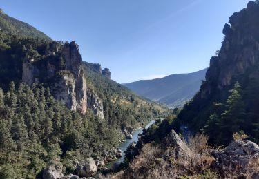
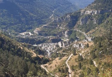
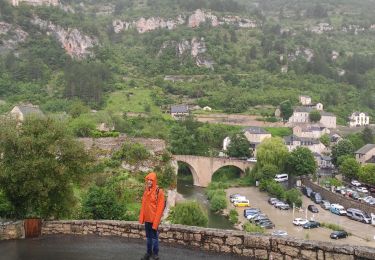
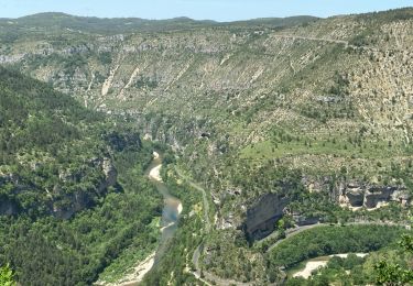
Randonnée Marche de 16,7 km à découvrir à Occitanie, Lozère, Gorges du Tarn Causses. Cette randonnée est proposée par Pousscailleux.
Description
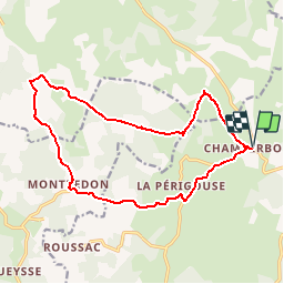
Départ de Champerboux.
Peu après Champerboux, le GR 60 est délaissé momentanément pour visiter le Puits de Fraisse au nord de la route. Le retour par Montredon et La Périgouse traverse une partie aride du Causse de Sauveterre.
Localisation
Pays :
France
Région :
Occitanie
Département/Province :
Lozère
Commune :
Gorges du Tarn Causses
Localité :
Sainte-Enimie
Départ:(Dec)
Départ:(UTM)
532935 ; 4917431 (31T) N.
Commentaires
Randonnées à proximité
![Randonnée Marche Gorges du Tarn Causses - Ste Enimie, le Boisset - Photo](https://media.geolcdn.com/t/375/260/c8e7aa0f-2f81-400e-a6dd-e67c5f500e2c.jpg&format=jpg&maxdim=2)
![Marche Marche](https://static1.geolcdn.com/sitytour/trail-icons/101.png)
Ste Enimie, le Boisset
Marche
Moyen
Gorges du Tarn Causses,
Occitanie,
Lozère,
France
![](/images/other/stat-length.png)
8,4 km | 14,6 km-effort
2h 33min
![](https://static1.geolcdn.com/siteimages/upload/files/16400158638029165_repeat_loop_refresh_sync_direction_icon.png)
Oui
![Randonnée Marche Gorges du Tarn Causses - Tour du Causse Méjean - Etape 1 - Photo](https://media.geolcdn.com/t/375/260/ext.jpg?maxdim=2&url=https%3A%2F%2Fservices.sitytrail.com%2FGeolivesWS%2FDownloadMedia.ashx%3FTrailID%3D1037411%26Media%3Dfix__20180831135516.jpg)
![Marche Marche](https://static1.geolcdn.com/sitytour/trail-icons/101.png)
Tour du Causse Méjean - Etape 1
Marche
Facile
Gorges du Tarn Causses,
Occitanie,
Lozère,
France
![](/images/other/stat-length.png)
15,5 km | 22 km-effort
4h 36min
![](https://static1.geolcdn.com/siteimages/upload/files/16400158638029165_repeat_loop_refresh_sync_direction_icon.png)
Non
![Randonnée Marche Gorges du Tarn Causses - Randonnée autour de Sainte-Enimie - Photo](https://media.geolcdn.com/t/375/260/ext.jpg?maxdim=2&url=https%3A%2F%2Fservices.sitytrail.com%2FGeolivesWS%2FDownloadMedia.ashx%3FTrailID%3D111759%26Media%3D8222_6.jpg)
![Marche Marche](https://static1.geolcdn.com/sitytour/trail-icons/101.png)
Randonnée autour de Sainte-Enimie
Marche
Moyen
(2)
Gorges du Tarn Causses,
Occitanie,
Lozère,
France
![](/images/other/stat-length.png)
7 km | 12,9 km-effort
3h 0min
![](https://static1.geolcdn.com/siteimages/upload/files/16400158638029165_repeat_loop_refresh_sync_direction_icon.png)
Oui
![Randonnée Moteur Gorges du Tarn Causses - Ste-Enimie - St-Rome - Photo](https://media.geolcdn.com/t/375/260/ext.jpg?maxdim=2&url=https%3A%2F%2Fstatic1.geolcdn.com%2Fsiteimages%2Fupload%2Ffiles%2F15247431544x4.jpg)
![Moteur Moteur](https://static1.geolcdn.com/sitytour/trail-icons/400.png)
Ste-Enimie - St-Rome
Moteur
Facile
(2)
Gorges du Tarn Causses,
Occitanie,
Lozère,
France
![](/images/other/stat-length.png)
36 km | 50 km-effort
Inconnu
![](https://static1.geolcdn.com/siteimages/upload/files/16400158638029165_repeat_loop_refresh_sync_direction_icon.png)
Non
![Randonnée Canoë - kayak Gorges du Tarn Causses - GR60 jour 8 Les Vignes - Photo](https://media.geolcdn.com/t/375/260/4666bd5a-fb1b-4da5-91d1-7868a4c22f75.jpg&format=jpg&maxdim=2)
![Canoë - kayak Canoë - kayak](https://static1.geolcdn.com/sitytour/trail-icons/703.png)
GR60 jour 8 Les Vignes
Canoë - kayak
Très facile
Gorges du Tarn Causses,
Occitanie,
Lozère,
France
![](/images/other/stat-length.png)
28 km | 38 km-effort
8h 57min
![](https://static1.geolcdn.com/siteimages/upload/files/16400158638029165_repeat_loop_refresh_sync_direction_icon.png)
Non
![Randonnée Marche Laval-du-Tarn - GR60 jour 8 Sainte Enimie - Photo](https://media.geolcdn.com/t/375/260/93624a29-a49b-490a-93e7-5e13d6226025.jpg&format=jpg&maxdim=2)
![Marche Marche](https://static1.geolcdn.com/sitytour/trail-icons/101.png)
GR60 jour 8 Sainte Enimie
Marche
Difficile
Laval-du-Tarn,
Occitanie,
Lozère,
France
![](/images/other/stat-length.png)
15,5 km | 19,3 km-effort
6h 10min
![](https://static1.geolcdn.com/siteimages/upload/files/16400158638029165_repeat_loop_refresh_sync_direction_icon.png)
Non
![Randonnée Marche Gorges du Tarn Causses - st enimie - Photo](https://media.geolcdn.com/t/375/260/593157cb-56eb-4249-a5c6-f6ce93eff1f2.jpg&format=jpg&maxdim=2)
![Marche Marche](https://static1.geolcdn.com/sitytour/trail-icons/101.png)
st enimie
Marche
Moyen
Gorges du Tarn Causses,
Occitanie,
Lozère,
France
![](/images/other/stat-length.png)
7,1 km | 9 km-effort
1h 38min
![](https://static1.geolcdn.com/siteimages/upload/files/16400158638029165_repeat_loop_refresh_sync_direction_icon.png)
Oui
![Randonnée Marche Gorges du Tarn Causses - champerboux pessade - Photo](https://media.geolcdn.com/t/375/260/a96ed76f-5129-4c42-9c64-bd216df03975.jpg&format=jpg&maxdim=2)
![Marche Marche](https://static1.geolcdn.com/sitytour/trail-icons/101.png)
champerboux pessade
Marche
Moyen
(1)
Gorges du Tarn Causses,
Occitanie,
Lozère,
France
![](/images/other/stat-length.png)
8,3 km | 11 km-effort
2h 8min
![](https://static1.geolcdn.com/siteimages/upload/files/16400158638029165_repeat_loop_refresh_sync_direction_icon.png)
Oui
![Marche nordique Marche nordique](https://static1.geolcdn.com/sitytour/trail-icons/102.png)
Sainte-Enimie - L'ermitage
Marche nordique
Très facile
Gorges du Tarn Causses,
Occitanie,
Lozère,
France
![](/images/other/stat-length.png)
1,8 km | 3,5 km-effort
1h 0min
![](https://static1.geolcdn.com/siteimages/upload/files/16400158638029165_repeat_loop_refresh_sync_direction_icon.png)
Oui