![](/images/other/stat-length.png)
![Randonnée Marche Kenmare Municipal District - Gap of Dunloe - Photo](https://media.geolcdn.com/t/1900/400/a45f8ed4-3ebb-45e2-a23a-debd623bea8b.jpg&format=pjpeg&maxdim=2)
Gap of Dunloe
Lobin
Utilisateur
![Longueur](/images/other/stat-length.png)
Longueur
11,1 km
![Altitude max](https://static1.geolcdn.com/siteimages/upload/files/1508320355ic_sort_altitude_max_24dp.png)
Altitude max
243 m
![Dénivelé positif](https://static1.geolcdn.com/siteimages/upload/files/1508320355ic_sort_den_pos_24dp.png)
Dénivelé positif
222 m
![Km-Effort](/images/other/stat-length.png)
Km-Effort
14,2 km
![Altitude min](https://static1.geolcdn.com/siteimages/upload/files/1508320355ic_sort_altitude_min_24dp.png)
Altitude min
23 m
![Dénivelé négatif](https://static1.geolcdn.com/siteimages/upload/files/1508320355ic_sort_den_neg_24dp.png)
Dénivelé négatif
256 m
![Boucle](https://static1.geolcdn.com/siteimages/upload/files/16400158638029165_repeat_loop_refresh_sync_direction_icon.png)
Boucle
Non
Date de création :
2024-03-31 09:50:56.0
Dernière modification :
2024-03-31 15:25:46.812
![Marche](https://static1.geolcdn.com/sitytour/trail-icons/101.png)
2h26
Difficulté : Moyen
![Scannez ce code QR pour ouvrir la randonnée dans l'application SityTrail](https://capi.geolives.com/qq0zvz2zws4bq2lad0pu/sitytour/trails/3999877/qr.png?size=200)
Application GPS de randonnée GRATUITE
À propos
Randonnée Marche de 11,1 km à découvrir à Inconnu, County Kerry, Kenmare Municipal District. Cette randonnée est proposée par Lobin.
Description
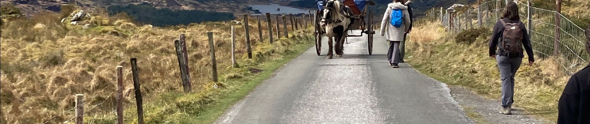
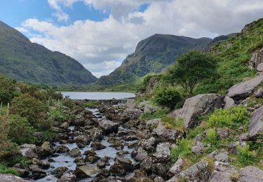
Il faut réserver la dépose en minibus au départ de la rando avec un Retour via les lacs.
Le chemin est une route mais ça vaut le coup. Le retour par les lacs est superbe
Localisation
Pays :
Irlande
Région :
Inconnu
Département/Province :
County Kerry
Commune :
Kenmare Municipal District
Localité :
Dunloe
Départ:(Dec)
Départ:(UTM)
456531 ; 5765573 (29U) N.
Commentaires
Randonnées à proximité
![Randonnée Marche Kenmare Municipal District - Parc National Killarney - Photo](https://media.geolcdn.com/t/375/260/12bfd884-912f-41c3-80f5-cf037d906335.jpg&format=jpg&maxdim=2)
![Marche Marche](https://static1.geolcdn.com/sitytour/trail-icons/101.png)
Parc National Killarney
Marche
Très difficile
Kenmare Municipal District,
Inconnu,
County Kerry,
Irlande
![](/images/other/stat-length.png)
28 km | 32 km-effort
7h 10min
![](https://static1.geolcdn.com/siteimages/upload/files/16400158638029165_repeat_loop_refresh_sync_direction_icon.png)
Non
![Randonnée Marche Kenmare Municipal District - Purlp montain - Photo](https://media.geolcdn.com/t/375/260/ext.jpg?maxdim=2&url=https%3A%2F%2Fstatic1.geolcdn.com%2Fsiteimages%2Fupload%2Ffiles%2F1553511878bg_sport_marche.png)
![Marche Marche](https://static1.geolcdn.com/sitytour/trail-icons/101.png)
Purlp montain
Marche
Difficile
Kenmare Municipal District,
Inconnu,
County Kerry,
Irlande
![](/images/other/stat-length.png)
14,5 km | 21 km-effort
Inconnu
![](https://static1.geolcdn.com/siteimages/upload/files/16400158638029165_repeat_loop_refresh_sync_direction_icon.png)
Oui
![Randonnée V.T.T. Kenmare Municipal District - Gap of Dunloe 2 - Photo](https://media.geolcdn.com/t/375/260/ext.jpg?maxdim=2&url=https%3A%2F%2Fstatic1.geolcdn.com%2Fsiteimages%2Fupload%2Ffiles%2F1524743154velo.jpg)
![V.T.T. V.T.T.](https://static1.geolcdn.com/sitytour/trail-icons/202.png)
Gap of Dunloe 2
V.T.T.
Très difficile
Kenmare Municipal District,
Inconnu,
County Kerry,
Irlande
![](/images/other/stat-length.png)
46 km | 55 km-effort
3h 47min
![](https://static1.geolcdn.com/siteimages/upload/files/16400158638029165_repeat_loop_refresh_sync_direction_icon.png)
Oui