![](/images/other/stat-length.png)
![Randonnée Marche Istres - Martigues entre les étangs de Citis et Lavalduc - Photo](https://media.geolcdn.com/t/1900/400/3676fb10-77ad-438e-9273-065789ad9a3e.jpg&format=pjpeg&maxdim=2)
Martigues entre les étangs de Citis et Lavalduc
jll7513
Utilisateur
![Longueur](/images/other/stat-length.png)
Longueur
6,9 km
![Altitude max](https://static1.geolcdn.com/siteimages/upload/files/1508320355ic_sort_altitude_max_24dp.png)
Altitude max
50 m
![Dénivelé positif](https://static1.geolcdn.com/siteimages/upload/files/1508320355ic_sort_den_pos_24dp.png)
Dénivelé positif
106 m
![Km-Effort](/images/other/stat-length.png)
Km-Effort
8,3 km
![Altitude min](https://static1.geolcdn.com/siteimages/upload/files/1508320355ic_sort_altitude_min_24dp.png)
Altitude min
-4 m
![Dénivelé négatif](https://static1.geolcdn.com/siteimages/upload/files/1508320355ic_sort_den_neg_24dp.png)
Dénivelé négatif
110 m
![Boucle](https://static1.geolcdn.com/siteimages/upload/files/16400158638029165_repeat_loop_refresh_sync_direction_icon.png)
Boucle
Oui
Date de création :
2024-03-24 08:51:35.0
Dernière modification :
2024-03-30 15:46:18.708
![Marche](https://static1.geolcdn.com/sitytour/trail-icons/101.png)
1h53
Difficulté : Moyen
![Marche nordique](https://static1.geolcdn.com/sitytour/trail-icons/102.png)
1h20
Difficulté : Facile
![Scannez ce code QR pour ouvrir la randonnée dans l'application SityTrail](https://capi.geolives.com/qq0zvz2zws4bq2lad0pu/sitytour/trails/3991879/qr.png?size=200)
Application GPS de randonnée GRATUITE
À propos
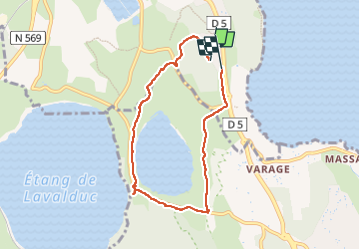
Randonnée Marche de 6,9 km à découvrir à Provence-Alpes-Côte d'Azur, Bouches-du-Rhône, Istres. Cette randonnée est proposée par jll7513.
Description
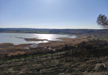
Et on peut en profiter, lorsque l'on est à mi-parcours au sud-ouest, juste entre les deux étangss de visiter le site archéologique de Saint-Blaise.
Localisation
Pays :
France
Région :
Provence-Alpes-Côte d'Azur
Département/Province :
Bouches-du-Rhône
Commune :
Istres
Localité :
Unknown
Départ:(Dec)
Départ:(UTM)
661245 ; 4816102 (31T) N.
Commentaires
Randonnées à proximité
![Randonnée Marche Istres - Entre ville et nature - Istres - Photo](https://media.geolcdn.com/t/375/260/ext.jpg?maxdim=2&url=https%3A%2F%2Fservices.sitytrail.com%2FGeolivesWS%2FDownloadMedia.ashx%3FTrailID%3D191380%26Media%3D14948_6.jpg)
![Marche Marche](https://static1.geolcdn.com/sitytour/trail-icons/101.png)
Entre ville et nature - Istres
Marche
Difficile
(2)
Istres,
Provence-Alpes-Côte d'Azur,
Bouches-du-Rhône,
France
![](/images/other/stat-length.png)
12,3 km | 14,7 km-effort
4h 0min
![](https://static1.geolcdn.com/siteimages/upload/files/16400158638029165_repeat_loop_refresh_sync_direction_icon.png)
Oui
![Randonnée A pied Saint-Mitre-les-Remparts - Forêt de Castillon Etang de Saint-Blaise - Photo](https://media.geolcdn.com/t/375/260/7e8fefba-ad96-4968-8724-bd86e53a7bcd.jpeg&format=jpg&maxdim=2)
![A pied A pied](https://static1.geolcdn.com/sitytour/trail-icons/100.png)
Forêt de Castillon Etang de Saint-Blaise
A pied
Facile
Saint-Mitre-les-Remparts,
Provence-Alpes-Côte d'Azur,
Bouches-du-Rhône,
France
![](/images/other/stat-length.png)
6,1 km | 7,1 km-effort
1h 36min
![](https://static1.geolcdn.com/siteimages/upload/files/16400158638029165_repeat_loop_refresh_sync_direction_icon.png)
Non
![Randonnée A pied Saint-Mitre-les-Remparts - Entre mer et étangs - Photo](https://media.geolcdn.com/t/375/260/95277df0-03ce-438e-8003-6258ba4d95b2.jpeg&format=jpg&maxdim=2)
![A pied A pied](https://static1.geolcdn.com/sitytour/trail-icons/100.png)
Entre mer et étangs
A pied
Très difficile
Saint-Mitre-les-Remparts,
Provence-Alpes-Côte d'Azur,
Bouches-du-Rhône,
France
![](/images/other/stat-length.png)
39 km | 46 km-effort
10h 22min
![](https://static1.geolcdn.com/siteimages/upload/files/16400158638029165_repeat_loop_refresh_sync_direction_icon.png)
Oui
![Randonnée A pied Saint-Mitre-les-Remparts - Du Crépon aux Rocalèdes - Photo](https://media.geolcdn.com/t/375/260/4fcd6c22-ec02-4372-a0e0-40334c408df3.jpeg&format=jpg&maxdim=2)
![A pied A pied](https://static1.geolcdn.com/sitytour/trail-icons/100.png)
Du Crépon aux Rocalèdes
A pied
Facile
Saint-Mitre-les-Remparts,
Provence-Alpes-Côte d'Azur,
Bouches-du-Rhône,
France
![](/images/other/stat-length.png)
6,1 km | 8 km-effort
1h 49min
![](https://static1.geolcdn.com/siteimages/upload/files/16400158638029165_repeat_loop_refresh_sync_direction_icon.png)
Oui
![Randonnée A pied Port-de-Bouc - Forêt de Castillon Etangs de Pourra et d’Engrenier - Photo](https://media.geolcdn.com/t/375/260/b4485374-af03-4dfc-85d7-4833d4297133.jpeg&format=jpg&maxdim=2)
![A pied A pied](https://static1.geolcdn.com/sitytour/trail-icons/100.png)
Forêt de Castillon Etangs de Pourra et d’Engrenier
A pied
Facile
Port-de-Bouc,
Provence-Alpes-Côte d'Azur,
Bouches-du-Rhône,
France
![](/images/other/stat-length.png)
6,1 km | 7,7 km-effort
1h 45min
![](https://static1.geolcdn.com/siteimages/upload/files/16400158638029165_repeat_loop_refresh_sync_direction_icon.png)
Non
![Randonnée A pied Saint-Mitre-les-Remparts - Les Tours Gros - Photo](https://media.geolcdn.com/t/375/260/4fcd6c22-ec02-4372-a0e0-40334c408df3.jpeg&format=jpg&maxdim=2)
![A pied A pied](https://static1.geolcdn.com/sitytour/trail-icons/100.png)
Les Tours Gros
A pied
Facile
Saint-Mitre-les-Remparts,
Provence-Alpes-Côte d'Azur,
Bouches-du-Rhône,
France
![](/images/other/stat-length.png)
6,2 km | 7,9 km-effort
1h 48min
![](https://static1.geolcdn.com/siteimages/upload/files/16400158638029165_repeat_loop_refresh_sync_direction_icon.png)
Oui
![Randonnée A pied Istres - Entre ville et nature (Istres) - Photo](https://media.geolcdn.com/t/375/260/c6b4632a-eacc-47f8-8cb4-22741d911e31.jpeg&format=jpg&maxdim=2)
![A pied A pied](https://static1.geolcdn.com/sitytour/trail-icons/100.png)
Entre ville et nature (Istres)
A pied
Facile
Istres,
Provence-Alpes-Côte d'Azur,
Bouches-du-Rhône,
France
![](/images/other/stat-length.png)
13,3 km | 15,7 km-effort
3h 34min
![](https://static1.geolcdn.com/siteimages/upload/files/16400158638029165_repeat_loop_refresh_sync_direction_icon.png)
Oui
![Randonnée Marche Istres - Miramas Istres GR 2013 ALLER - Photo](https://media.geolcdn.com/t/375/260/ext.jpg?maxdim=2&url=https%3A%2F%2Fstatic1.geolcdn.com%2Fsiteimages%2Fupload%2Ffiles%2F1553511878bg_sport_marche.png)
![Marche Marche](https://static1.geolcdn.com/sitytour/trail-icons/101.png)
Miramas Istres GR 2013 ALLER
Marche
Facile
(2)
Istres,
Provence-Alpes-Côte d'Azur,
Bouches-du-Rhône,
France
![](/images/other/stat-length.png)
7,6 km | 10 km-effort
2h 6min
![](https://static1.geolcdn.com/siteimages/upload/files/16400158638029165_repeat_loop_refresh_sync_direction_icon.png)
Non
![Randonnée Marche Istres - Le Ranquet-Istres 30.11.24 - Photo](https://media.geolcdn.com/t/375/260/edae3387-dbd2-44f3-a355-b8e1e68c6a61.jpg&format=jpg&maxdim=2)
![Marche Marche](https://static1.geolcdn.com/sitytour/trail-icons/101.png)
Le Ranquet-Istres 30.11.24
Marche
Facile
Istres,
Provence-Alpes-Côte d'Azur,
Bouches-du-Rhône,
France
![](/images/other/stat-length.png)
11,7 km | 14,2 km-effort
3h 30min
![](https://static1.geolcdn.com/siteimages/upload/files/16400158638029165_repeat_loop_refresh_sync_direction_icon.png)
Oui