![](/images/other/stat-length.png)
![Randonnée Marche Haecht - Wespelaar - Leuven 22 km - Photo](https://media.geolcdn.com/t/1900/400/0e0abcdd-4dc0-4fa3-9db9-e658c130a57b.jpg&format=pjpeg&maxdim=2)
Wespelaar - Leuven 22 km
rvapeldo
Utilisateur GUIDE
![Longueur](/images/other/stat-length.png)
![Altitude max](https://static1.geolcdn.com/siteimages/upload/files/1508320355ic_sort_altitude_max_24dp.png)
![Dénivelé positif](https://static1.geolcdn.com/siteimages/upload/files/1508320355ic_sort_den_pos_24dp.png)
![Km-Effort](/images/other/stat-length.png)
![Altitude min](https://static1.geolcdn.com/siteimages/upload/files/1508320355ic_sort_altitude_min_24dp.png)
![Dénivelé négatif](https://static1.geolcdn.com/siteimages/upload/files/1508320355ic_sort_den_neg_24dp.png)
![Boucle](https://static1.geolcdn.com/siteimages/upload/files/16400158638029165_repeat_loop_refresh_sync_direction_icon.png)
![Marche](https://static1.geolcdn.com/sitytour/trail-icons/101.png)
6h02
Difficulté : Moyen
![Scannez ce code QR pour ouvrir la randonnée dans l'application SityTrail](https://capi.geolives.com/qq0zvz2zws4bq2lad0pu/sitytour/trails/3990949/qr.png?size=200)
Application GPS de randonnée GRATUITE
À propos
Randonnée Marche de 23 km à découvrir à Flandre, Brabant flamand, Haecht. Cette randonnée est proposée par rvapeldo.
Description
(NL hieronder)
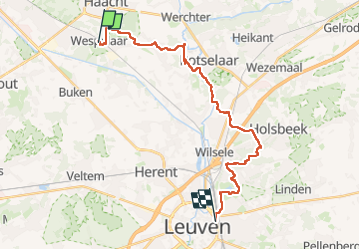
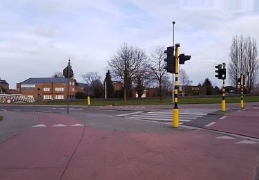
Parcours de gare à gare de Grote Route Paden, qui fait 21 km à l’origine. Il s’est un peu allongé car j’ai garé l’auto à l’église et non à la gare, et il y a quelques erreurs (on le voit à des aller-retours qu’il y a moyen d’éliminer).
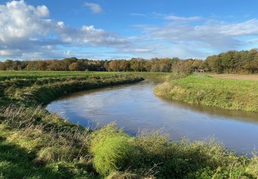
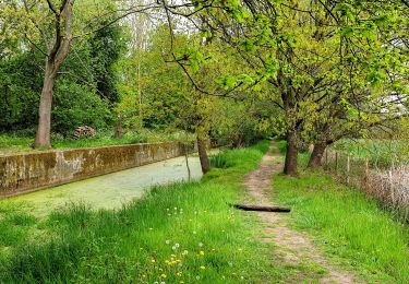
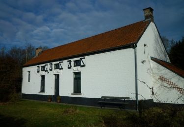
Charmante promenade au pays de la Dyle au départ de Wespelaar vers Leuven, entre champs et prés, via Rotselaar et le Kesselberg, qui est le « gros » dénivelé du parcours (jusqu’à 79 mètres d’altitude), avant de serpenter dans le environs de Leuven. Il y a moyen d’ajouter une petite visite de Leuven en fin de parcours. Il y a un train par heure durant le week-end.
Route van station naar station van Grote Route Paden, oorspronkelijk 21 km. Het is iets langer geworden omdat ik de auto bij de kerk heb geparkeerd en niet bij het station, en er staan een paar fouten in (je kunt het zien op de heen- en terugreis die er is een manier om te elimineren).
Charmante wandeling in het Dijleland van Wespelaar richting Leuven, tussen velden en weilanden, via Rotselaar en de Kesselberg, het "grote" hoogteverschil van de route (tot 79 meter boven zeeniveau), alvorens te slingeren door de omgeving van Leuven. Er bestaat een mogelijkheid om op het einde van de maand een kort bezoek aan Leuven toe te voegen
Localisation
Commentaires
Randonnées à proximité
![Randonnée Marche Bonheiden - Hever - Photo](https://media.geolcdn.com/t/375/260/ext.jpg?maxdim=2&url=https%3A%2F%2Fservices.sitytrail.com%2FGeolivesWS%2FDownloadMedia.ashx%3FTrailID%3D656803%26Media%3Dfix__20161020152445.jpg)
![Marche Marche](https://static1.geolcdn.com/sitytour/trail-icons/101.png)
![Randonnée A pied Rotselaer - Zegbroek Rood Vierkant - Photo](https://media.geolcdn.com/t/375/260/77e1137b-05dd-4358-a25f-2bc0db9b4976.jpeg&format=jpg&maxdim=2)
![A pied A pied](https://static1.geolcdn.com/sitytour/trail-icons/100.png)
A pied
![](/images/other/stat-length.png)
![](https://static1.geolcdn.com/siteimages/upload/files/16400158638029165_repeat_loop_refresh_sync_direction_icon.png)
![Randonnée A pied Rotselaer - Zegbroek Groene Ruit - Photo](https://media.geolcdn.com/t/375/260/77e1137b-05dd-4358-a25f-2bc0db9b4976.jpeg&format=jpg&maxdim=2)
![A pied A pied](https://static1.geolcdn.com/sitytour/trail-icons/100.png)
A pied
![](/images/other/stat-length.png)
![](https://static1.geolcdn.com/siteimages/upload/files/16400158638029165_repeat_loop_refresh_sync_direction_icon.png)
![Randonnée A pied Rotselaer - Demer- en Dijlewandeling - Photo](https://media.geolcdn.com/t/375/260/07ab4046-9445-4412-b949-db02a814aaf8.jpeg&format=jpg&maxdim=2)
![A pied A pied](https://static1.geolcdn.com/sitytour/trail-icons/100.png)
A pied
![](/images/other/stat-length.png)
![](https://static1.geolcdn.com/siteimages/upload/files/16400158638029165_repeat_loop_refresh_sync_direction_icon.png)
![Randonnée Marche Kampenhout - kalmthout1 - Photo](https://media.geolcdn.com/t/375/260/65b8a2b2-6179-4a30-95cf-59d99607e1c6.jpg&format=jpg&maxdim=2)
![Marche Marche](https://static1.geolcdn.com/sitytour/trail-icons/101.png)
Marche
![](/images/other/stat-length.png)
![](https://static1.geolcdn.com/siteimages/upload/files/16400158638029165_repeat_loop_refresh_sync_direction_icon.png)
![Randonnée Marche Haecht - S-GR Dijleland: Haacht - Muizen - Photo](https://media.geolcdn.com/t/375/260/088fa55e-fe65-4e9b-8757-364eafed9bb1.jpeg&format=jpg&maxdim=2)
![Marche Marche](https://static1.geolcdn.com/sitytour/trail-icons/101.png)
Marche
![](/images/other/stat-length.png)
![](https://static1.geolcdn.com/siteimages/upload/files/16400158638029165_repeat_loop_refresh_sync_direction_icon.png)
![Randonnée Marche Haecht - Wespelaar: Haachts Broek et Antitankgracht - Photo](https://media.geolcdn.com/t/375/260/e85e6feb-7b0b-4775-a84c-505ebdc4aad1.jpeg&format=jpg&maxdim=2)
![Marche Marche](https://static1.geolcdn.com/sitytour/trail-icons/101.png)
Marche
![](/images/other/stat-length.png)
![](https://static1.geolcdn.com/siteimages/upload/files/16400158638029165_repeat_loop_refresh_sync_direction_icon.png)
![Randonnée Marche Haecht - Haecht - Photo](https://media.geolcdn.com/t/375/260/3d78cd58-fd60-41d9-a7d8-78323be4334b.jpg&format=jpg&maxdim=2)
![Marche Marche](https://static1.geolcdn.com/sitytour/trail-icons/101.png)
Marche
![](/images/other/stat-length.png)
![](https://static1.geolcdn.com/siteimages/upload/files/16400158638029165_repeat_loop_refresh_sync_direction_icon.png)
![Randonnée A pied Tremelo - Laekdal Blauwe Rechthoek - Photo](https://media.geolcdn.com/t/375/260/7d888d33-9d48-470a-b9f8-0f55a82f9335.jpeg&format=jpg&maxdim=2)
![A pied A pied](https://static1.geolcdn.com/sitytour/trail-icons/100.png)
A pied
![](/images/other/stat-length.png)
![](https://static1.geolcdn.com/siteimages/upload/files/16400158638029165_repeat_loop_refresh_sync_direction_icon.png)