![](/images/other/stat-length.png)
![Randonnée Marche Nicole - ASPTT DU 21/03/2024 _ Boucle Ayet/Pech de Berre/Ayet - Photo](https://media.geolcdn.com/t/1900/400/ext.pjpeg?maxdim=2&url=https%3A%2F%2Fstatic1.geolcdn.com%2Fsiteimages%2Fupload%2Ffiles%2F1553511878bg_sport_marche.png)
ASPTT DU 21/03/2024 _ Boucle Ayet/Pech de Berre/Ayet
Elbe
Utilisateur
![Longueur](/images/other/stat-length.png)
Longueur
11,1 km
![Altitude max](https://static1.geolcdn.com/siteimages/upload/files/1508320355ic_sort_altitude_max_24dp.png)
Altitude max
172 m
![Dénivelé positif](https://static1.geolcdn.com/siteimages/upload/files/1508320355ic_sort_den_pos_24dp.png)
Dénivelé positif
316 m
![Km-Effort](/images/other/stat-length.png)
Km-Effort
15,3 km
![Altitude min](https://static1.geolcdn.com/siteimages/upload/files/1508320355ic_sort_altitude_min_24dp.png)
Altitude min
45 m
![Dénivelé négatif](https://static1.geolcdn.com/siteimages/upload/files/1508320355ic_sort_den_neg_24dp.png)
Dénivelé négatif
313 m
![Boucle](https://static1.geolcdn.com/siteimages/upload/files/16400158638029165_repeat_loop_refresh_sync_direction_icon.png)
Boucle
Oui
Date de création :
2024-03-21 13:08:34.969
Dernière modification :
2024-03-24 16:14:37.564
![Marche](https://static1.geolcdn.com/sitytour/trail-icons/101.png)
3h28
Difficulté : Difficile
![Scannez ce code QR pour ouvrir la randonnée dans l'application SityTrail](https://capi.geolives.com/qq0zvz2zws4bq2lad0pu/sitytour/trails/3989073/qr.png?size=200)
Application GPS de randonnée GRATUITE
À propos
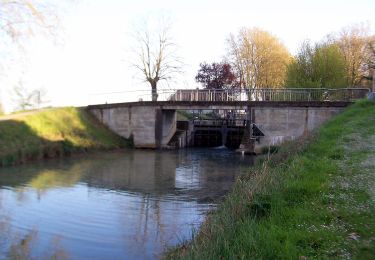
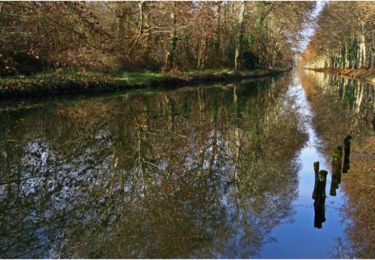
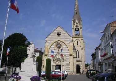
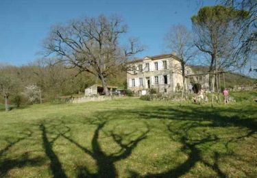
Randonnée Marche de 11,1 km à découvrir à Nouvelle-Aquitaine, Lot-et-Garonne, Nicole. Cette randonnée est proposée par Elbe.
Description
Cette balade qui offre de nombreux panoramas sur les deux vallées du confluent est une des variantes de la rando du Lot & Garonne.
Localisation
Pays :
France
Région :
Nouvelle-Aquitaine
Département/Province :
Lot-et-Garonne
Commune :
Nicole
Localité :
Unknown
Départ:(Dec)
Départ:(UTM)
287378 ; 4913257 (31T) N.
Commentaires
Randonnées à proximité
![Randonnée Marche Tonneins - Unet, petite randonnée entre Garonne et Lot - Pays Val de Garonne - Gascogne - Photo](https://media.geolcdn.com/t/375/260/ext.jpg?maxdim=2&url=https%3A%2F%2Fservices.sitytrail.com%2FGeolivesWS%2FDownloadMedia.ashx%3FTrailID%3D110735%26Media%3D6263_1.jpg)
![Marche Marche](https://static1.geolcdn.com/sitytour/trail-icons/101.png)
Unet, petite randonnée entre Garonne et Lot - Pays Val de Garonne - Gascogne
Marche
Moyen
(1)
Tonneins,
Nouvelle-Aquitaine,
Lot-et-Garonne,
France
![](/images/other/stat-length.png)
5,6 km | 7,8 km-effort
2h 0min
![](https://static1.geolcdn.com/siteimages/upload/files/16400158638029165_repeat_loop_refresh_sync_direction_icon.png)
Oui
![Randonnée A pied Puch-d'Agenais - Damazan, la Bastide du Canal de Garonne - 9,8km - Photo](https://media.geolcdn.com/t/375/260/955b4ae8-ce27-4a8a-bfc0-015d1284cb45.jpeg&format=jpg&maxdim=2)
![A pied A pied](https://static1.geolcdn.com/sitytour/trail-icons/100.png)
Damazan, la Bastide du Canal de Garonne - 9,8km
A pied
Facile
Puch-d'Agenais,
Nouvelle-Aquitaine,
Lot-et-Garonne,
France
![](/images/other/stat-length.png)
3,6 km | 3,9 km-effort
52min
![](https://static1.geolcdn.com/siteimages/upload/files/16400158638029165_repeat_loop_refresh_sync_direction_icon.png)
Non
![Randonnée A pied Monheurt - Monheurt, balade entre Garonne et canal - 7 km - Photo](https://media.geolcdn.com/t/375/260/ext.jpg?maxdim=2&url=https%3A%2F%2Fstatic1.geolcdn.com%2Fsiteimages%2Fupload%2Ffiles%2F1545311037marcheuse_200dpi.jpg)
![A pied A pied](https://static1.geolcdn.com/sitytour/trail-icons/100.png)
Monheurt, balade entre Garonne et canal - 7 km
A pied
Facile
Monheurt,
Nouvelle-Aquitaine,
Lot-et-Garonne,
France
![](/images/other/stat-length.png)
6,8 km | 7,5 km-effort
1h 41min
![](https://static1.geolcdn.com/siteimages/upload/files/16400158638029165_repeat_loop_refresh_sync_direction_icon.png)
Oui
![Randonnée V.T.T. Monheurt - Monheurt, balade entre Garonne et Canal - Pays de la vallée du Lot - Photo](https://media.geolcdn.com/t/375/260/ext.jpg?maxdim=2&url=https%3A%2F%2Fservices.sitytrail.com%2FGeolivesWS%2FDownloadMedia.ashx%3FTrailID%3D112389%26Media%3D10515_1.jpg)
![V.T.T. V.T.T.](https://static1.geolcdn.com/sitytour/trail-icons/202.png)
Monheurt, balade entre Garonne et Canal - Pays de la vallée du Lot
V.T.T.
Moyen
Monheurt,
Nouvelle-Aquitaine,
Lot-et-Garonne,
France
![](/images/other/stat-length.png)
9,1 km | 10,1 km-effort
34min
![](https://static1.geolcdn.com/siteimages/upload/files/16400158638029165_repeat_loop_refresh_sync_direction_icon.png)
Oui
![Randonnée Marche Monheurt - Monheurt, balade entre Garonne et Canal - Pays de la vallée du Lot - Photo](https://media.geolcdn.com/t/375/260/ext.jpg?maxdim=2&url=https%3A%2F%2Fservices.sitytrail.com%2FGeolivesWS%2FDownloadMedia.ashx%3FTrailID%3D112388%26Media%3D10515_1.jpg)
![Marche Marche](https://static1.geolcdn.com/sitytour/trail-icons/101.png)
Monheurt, balade entre Garonne et Canal - Pays de la vallée du Lot
Marche
Moyen
Monheurt,
Nouvelle-Aquitaine,
Lot-et-Garonne,
France
![](/images/other/stat-length.png)
9,1 km | 10,1 km-effort
2h 30min
![](https://static1.geolcdn.com/siteimages/upload/files/16400158638029165_repeat_loop_refresh_sync_direction_icon.png)
Oui
![Randonnée Marche Clairac - Clairac, une boucle semi urbaine au bord du Lot - Pays de la vallée du Lot - Photo](https://media.geolcdn.com/t/375/260/ext.jpg?maxdim=2&url=https%3A%2F%2Fservices.sitytrail.com%2FGeolivesWS%2FDownloadMedia.ashx%3FTrailID%3D110752%26Media%3D6274_1.jpg)
![Marche Marche](https://static1.geolcdn.com/sitytour/trail-icons/101.png)
Clairac, une boucle semi urbaine au bord du Lot - Pays de la vallée du Lot
Marche
Facile
Clairac,
Nouvelle-Aquitaine,
Lot-et-Garonne,
France
![](/images/other/stat-length.png)
4,9 km | 5,5 km-effort
1h 40min
![](https://static1.geolcdn.com/siteimages/upload/files/16400158638029165_repeat_loop_refresh_sync_direction_icon.png)
Oui
![Randonnée V.T.T. Aiguillon - Aiguillon, bastide française au confluent du Lot et de la Garonne - Pays de la vallée du Lot - Photo](https://media.geolcdn.com/t/375/260/ext.jpg?maxdim=2&url=https%3A%2F%2Fservices.sitytrail.com%2FGeolivesWS%2FDownloadMedia.ashx%3FTrailID%3D110742%26Media%3D6266_1.jpg)
![V.T.T. V.T.T.](https://static1.geolcdn.com/sitytour/trail-icons/202.png)
Aiguillon, bastide française au confluent du Lot et de la Garonne - Pays de l...
V.T.T.
Difficile
Aiguillon,
Nouvelle-Aquitaine,
Lot-et-Garonne,
France
![](/images/other/stat-length.png)
15 km | 19,2 km-effort
2h 0min
![](https://static1.geolcdn.com/siteimages/upload/files/16400158638029165_repeat_loop_refresh_sync_direction_icon.png)
Oui
![Randonnée Marche Aiguillon - Aiguillon, bastide française au confluent du Lot et de la Garonne - Pays de la vallée du Lot - Photo](https://media.geolcdn.com/t/375/260/ext.jpg?maxdim=2&url=https%3A%2F%2Fservices.sitytrail.com%2FGeolivesWS%2FDownloadMedia.ashx%3FTrailID%3D110741%26Media%3D6266_1.jpg)
![Marche Marche](https://static1.geolcdn.com/sitytour/trail-icons/101.png)
Aiguillon, bastide française au confluent du Lot et de la Garonne - Pays de l...
Marche
Difficile
Aiguillon,
Nouvelle-Aquitaine,
Lot-et-Garonne,
France
![](/images/other/stat-length.png)
15 km | 19,2 km-effort
4h 0min
![](https://static1.geolcdn.com/siteimages/upload/files/16400158638029165_repeat_loop_refresh_sync_direction_icon.png)
Oui
![Randonnée V.T.T. Tonneins - Unet, petite randonnée entre Garonne et Lot - Pays Val de Garonne - Gascogne - Photo](https://media.geolcdn.com/t/375/260/ext.jpg?maxdim=2&url=https%3A%2F%2Fservices.sitytrail.com%2FGeolivesWS%2FDownloadMedia.ashx%3FTrailID%3D110736%26Media%3D6263_1.jpg)
![V.T.T. V.T.T.](https://static1.geolcdn.com/sitytour/trail-icons/202.png)
Unet, petite randonnée entre Garonne et Lot - Pays Val de Garonne - Gascogne
V.T.T.
Moyen
Tonneins,
Nouvelle-Aquitaine,
Lot-et-Garonne,
France
![](/images/other/stat-length.png)
5,6 km | 7,8 km-effort
45min
![](https://static1.geolcdn.com/siteimages/upload/files/16400158638029165_repeat_loop_refresh_sync_direction_icon.png)
Oui