![](/images/other/stat-length.png)
![Randonnée Raquettes à neige Crots - Lac du Lauzerot par les Gendres et clot Besson - Photo](https://media.geolcdn.com/t/1900/400/ext.pjpeg?maxdim=2&url=https%3A%2F%2Fstatic1.geolcdn.com%2Fsiteimages%2Fupload%2Ffiles%2F1524743153raquette.jpg)
Lac du Lauzerot par les Gendres et clot Besson
damlou
Utilisateur
![Longueur](/images/other/stat-length.png)
Longueur
8,3 km
![Altitude max](https://static1.geolcdn.com/siteimages/upload/files/1508320355ic_sort_altitude_max_24dp.png)
Altitude max
1950 m
![Dénivelé positif](https://static1.geolcdn.com/siteimages/upload/files/1508320355ic_sort_den_pos_24dp.png)
Dénivelé positif
450 m
![Km-Effort](/images/other/stat-length.png)
Km-Effort
14,3 km
![Altitude min](https://static1.geolcdn.com/siteimages/upload/files/1508320355ic_sort_altitude_min_24dp.png)
Altitude min
1572 m
![Dénivelé négatif](https://static1.geolcdn.com/siteimages/upload/files/1508320355ic_sort_den_neg_24dp.png)
Dénivelé négatif
454 m
![Boucle](https://static1.geolcdn.com/siteimages/upload/files/16400158638029165_repeat_loop_refresh_sync_direction_icon.png)
Boucle
Oui
Date de création :
2024-03-05 08:43:27.355
Dernière modification :
2024-03-05 14:57:42.416
![Raquettes à neige](https://static1.geolcdn.com/sitytour/trail-icons/504.png)
2h51
Difficulté : Moyen
![Scannez ce code QR pour ouvrir la randonnée dans l'application SityTrail](https://capi.geolives.com/qq0zvz2zws4bq2lad0pu/sitytour/trails/3970917/qr.png?size=200)
Application GPS de randonnée GRATUITE
À propos
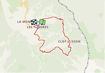
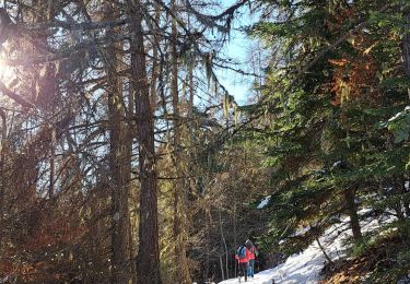
Randonnée Raquettes à neige de 8,3 km à découvrir à Provence-Alpes-Côte d'Azur, Hautes-Alpes, Crots. Cette randonnée est proposée par damlou.
Description
Depart les Gendres rejoindre parcours de la Draye clot Besson descendre par chapelle du Lauzerot
Localisation
Pays :
France
Région :
Provence-Alpes-Côte d'Azur
Département/Province :
Hautes-Alpes
Commune :
Crots
Localité :
Unknown
Départ:(Dec)
Départ:(UTM)
299588 ; 4929462 (32T) N.
Commentaires
Randonnées à proximité
![Randonnée Marche Crots - Le Cirque de Morgon - Photo](https://media.geolcdn.com/t/375/260/ext.jpg?maxdim=2&url=https%3A%2F%2Fservices.sitytrail.com%2FGeolivesWS%2FDownloadMedia.ashx%3FTrailID%3D109626%26Media%3D4261_1.jpg)
![Marche Marche](https://static1.geolcdn.com/sitytour/trail-icons/101.png)
Le Cirque de Morgon
Marche
Difficile
(5)
Crots,
Provence-Alpes-Côte d'Azur,
Hautes-Alpes,
France
![](/images/other/stat-length.png)
10,6 km | 21 km-effort
5h 30min
![](https://static1.geolcdn.com/siteimages/upload/files/16400158638029165_repeat_loop_refresh_sync_direction_icon.png)
Oui
![Randonnée Marche Crots - Morgon par le Grand Clot - Photo](https://media.geolcdn.com/t/375/260/2470b249-9732-40d6-87a8-fc728b4285cc.jpg&format=jpg&maxdim=2)
![Marche Marche](https://static1.geolcdn.com/sitytour/trail-icons/101.png)
Morgon par le Grand Clot
Marche
Facile
(1)
Crots,
Provence-Alpes-Côte d'Azur,
Hautes-Alpes,
France
![](/images/other/stat-length.png)
11,8 km | 22 km-effort
5h 49min
![](https://static1.geolcdn.com/siteimages/upload/files/16400158638029165_repeat_loop_refresh_sync_direction_icon.png)
Oui
![Randonnée Marche Crots - Grand Morgon - Photo](https://media.geolcdn.com/t/375/260/c2ea8bef-d143-4c62-a26e-6fbe8e0329c8.jpg&format=jpg&maxdim=2)
![Marche Marche](https://static1.geolcdn.com/sitytour/trail-icons/101.png)
Grand Morgon
Marche
Moyen
Crots,
Provence-Alpes-Côte d'Azur,
Hautes-Alpes,
France
![](/images/other/stat-length.png)
11,4 km | 22 km-effort
4h 56min
![](https://static1.geolcdn.com/siteimages/upload/files/16400158638029165_repeat_loop_refresh_sync_direction_icon.png)
Oui
![Randonnée Marche Crots - Pic de Morgon par le Grand Clot - Photo](https://media.geolcdn.com/t/375/260/1bb998f8-1a6a-4350-bb2c-9f136211e7d5.jpg&format=jpg&maxdim=2)
![Marche Marche](https://static1.geolcdn.com/sitytour/trail-icons/101.png)
Pic de Morgon par le Grand Clot
Marche
Moyen
Crots,
Provence-Alpes-Côte d'Azur,
Hautes-Alpes,
France
![](/images/other/stat-length.png)
11,8 km | 22 km-effort
5h 30min
![](https://static1.geolcdn.com/siteimages/upload/files/16400158638029165_repeat_loop_refresh_sync_direction_icon.png)
Oui
![Randonnée Marche Crots - Morgon par la fontaine de l'Ours - Photo](https://media.geolcdn.com/t/375/260/e020d87b-3349-4509-bff9-6b59601d138c.jpg&format=jpg&maxdim=2)
![Marche Marche](https://static1.geolcdn.com/sitytour/trail-icons/101.png)
Morgon par la fontaine de l'Ours
Marche
Moyen
Crots,
Provence-Alpes-Côte d'Azur,
Hautes-Alpes,
France
![](/images/other/stat-length.png)
17,7 km | 33 km-effort
6h 26min
![](https://static1.geolcdn.com/siteimages/upload/files/16400158638029165_repeat_loop_refresh_sync_direction_icon.png)
Oui
![Randonnée Marche Crots - LES CROTS Boscodon ,Fontaine de l Ours ,sentier des Pyramides cirque du Morgon o m - Photo](https://media.geolcdn.com/t/375/260/94dbf83e-b1dc-42f7-b3af-31980f7aee36.jpg&format=jpg&maxdim=2)
![Marche Marche](https://static1.geolcdn.com/sitytour/trail-icons/101.png)
LES CROTS Boscodon ,Fontaine de l Ours ,sentier des Pyramides cirque d...
Marche
Difficile
Crots,
Provence-Alpes-Côte d'Azur,
Hautes-Alpes,
France
![](/images/other/stat-length.png)
12,6 km | 22 km-effort
4h 10min
![](https://static1.geolcdn.com/siteimages/upload/files/16400158638029165_repeat_loop_refresh_sync_direction_icon.png)
Oui
![Randonnée Marche Crots - Crots - le Grand Clot Cirque de Morgon - 9.2km 550m 3h20 - 2018 06 25 - Photo](https://media.geolcdn.com/t/375/260/ext.jpg?maxdim=2&url=https%3A%2F%2Fservices.sitytrail.com%2FGeolivesWS%2FDownloadMedia.ashx%3FTrailID%3D999318%26Media%3Dfix__20180625114434.jpg)
![Marche Marche](https://static1.geolcdn.com/sitytour/trail-icons/101.png)
Crots - le Grand Clot Cirque de Morgon - 9.2km 550m 3h20 - 2018 06 25
Marche
Moyen
Crots,
Provence-Alpes-Côte d'Azur,
Hautes-Alpes,
France
![](/images/other/stat-length.png)
9,2 km | 16,4 km-effort
3h 20min
![](https://static1.geolcdn.com/siteimages/upload/files/16400158638029165_repeat_loop_refresh_sync_direction_icon.png)
Oui
![Randonnée Marche Crots - Col des Olettes - Photo](https://media.geolcdn.com/t/375/260/ext.jpg?maxdim=2&url=https%3A%2F%2Fstatic1.geolcdn.com%2Fsiteimages%2Fupload%2Ffiles%2F1553511878bg_sport_marche.png)
![Marche Marche](https://static1.geolcdn.com/sitytour/trail-icons/101.png)
Col des Olettes
Marche
Facile
(1)
Crots,
Provence-Alpes-Côte d'Azur,
Hautes-Alpes,
France
![](/images/other/stat-length.png)
11,8 km | 23 km-effort
4h 53min
![](https://static1.geolcdn.com/siteimages/upload/files/16400158638029165_repeat_loop_refresh_sync_direction_icon.png)
Oui
![Randonnée Raquettes à neige Crots - EMBRUN Jour 2 : Abbaye de Boscodon - Le Cirque de Morgon - Photo](https://media.geolcdn.com/t/375/260/2eb3735b-35d8-4d28-be63-61cac8c26d41.jpg&format=jpg&maxdim=2)
![Raquettes à neige Raquettes à neige](https://static1.geolcdn.com/sitytour/trail-icons/504.png)
EMBRUN Jour 2 : Abbaye de Boscodon - Le Cirque de Morgon
Raquettes à neige
Moyen
Crots,
Provence-Alpes-Côte d'Azur,
Hautes-Alpes,
France
![](/images/other/stat-length.png)
12 km | 22 km-effort
6h 3min
![](https://static1.geolcdn.com/siteimages/upload/files/16400158638029165_repeat_loop_refresh_sync_direction_icon.png)
Oui
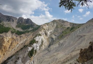
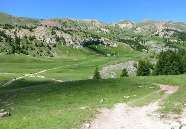
Descente superbe en coupant avec Guy Retour aux Gendres à plat souvent ss neige