![](/images/other/stat-length.png)
![Randonnée Marche Seyssinet-Pariset - Boucle dans les Vouillants au départ de l'église de Seyssinet - Photo](https://media.geolcdn.com/t/1900/400/ae79d5f0-9053-4858-840a-4ce6392bc32e.jpg&format=pjpeg&maxdim=2)
Boucle dans les Vouillants au départ de l'église de Seyssinet
patjobou
Utilisateur
![Longueur](/images/other/stat-length.png)
![Altitude max](https://static1.geolcdn.com/siteimages/upload/files/1508320355ic_sort_altitude_max_24dp.png)
![Dénivelé positif](https://static1.geolcdn.com/siteimages/upload/files/1508320355ic_sort_den_pos_24dp.png)
![Km-Effort](/images/other/stat-length.png)
![Altitude min](https://static1.geolcdn.com/siteimages/upload/files/1508320355ic_sort_altitude_min_24dp.png)
![Dénivelé négatif](https://static1.geolcdn.com/siteimages/upload/files/1508320355ic_sort_den_neg_24dp.png)
![Boucle](https://static1.geolcdn.com/siteimages/upload/files/16400158638029165_repeat_loop_refresh_sync_direction_icon.png)
![Marche](https://static1.geolcdn.com/sitytour/trail-icons/101.png)
3h01
Difficulté : Moyen
![Marche nordique](https://static1.geolcdn.com/sitytour/trail-icons/102.png)
3h00
Difficulté : Moyen
![Scannez ce code QR pour ouvrir la randonnée dans l'application SityTrail](https://capi.geolives.com/qq0zvz2zws4bq2lad0pu/sitytour/trails/3965671/qr.png?size=200)
Application GPS de randonnée GRATUITE
À propos
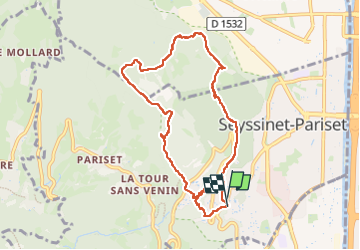
Randonnée Marche de 8,7 km à découvrir à Auvergne-Rhône-Alpes, Isère, Seyssinet-Pariset. Cette randonnée est proposée par patjobou.
Description
Boucle intéressante par son point de départ qui change un peu du traditionnel parking Beauregard.
Compter 20 minutes de descente entre le parking Beauregard et l'église de Seyssinet. il est préférable de tourner dans le sens choisi. 3h en tout.
Localisation
Commentaires
Randonnées à proximité
![Randonnée Marche Sassenage - La ferme Durand - Photo](https://media.geolcdn.com/t/375/260/94c22489-8db0-4cec-b019-90eab5ac0fa3.jpg&format=jpg&maxdim=2)
![Marche Marche](https://static1.geolcdn.com/sitytour/trail-icons/101.png)
Marche
![](/images/other/stat-length.png)
![](https://static1.geolcdn.com/siteimages/upload/files/16400158638029165_repeat_loop_refresh_sync_direction_icon.png)
![Randonnée Marche nordique Sassenage - Parc de l'Ovalie - Noyarey - Photo](https://media.geolcdn.com/t/375/260/d032ba44-c97c-4141-ba1d-c30342d72d38.jpg&format=jpg&maxdim=2)
![Marche nordique Marche nordique](https://static1.geolcdn.com/sitytour/trail-icons/102.png)
Marche nordique
![](/images/other/stat-length.png)
![](https://static1.geolcdn.com/siteimages/upload/files/16400158638029165_repeat_loop_refresh_sync_direction_icon.png)
![Randonnée Marche nordique Seyssins - Seyssins le haut - Les Arcelles dans la neige - Photo](https://media.geolcdn.com/t/375/260/09832c62-e152-4e15-aea9-389ff5328b66.jpg&format=jpg&maxdim=2)
![Marche nordique Marche nordique](https://static1.geolcdn.com/sitytour/trail-icons/102.png)
Marche nordique
![](/images/other/stat-length.png)
![](https://static1.geolcdn.com/siteimages/upload/files/16400158638029165_repeat_loop_refresh_sync_direction_icon.png)
![Randonnée Marche Seyssins - MOUCHEROTTE - Photo](https://media.geolcdn.com/t/375/260/fbc259ea-06fa-4a05-83ef-656dc650e275.jpg&format=jpg&maxdim=2)
![Marche Marche](https://static1.geolcdn.com/sitytour/trail-icons/101.png)
Marche
![](/images/other/stat-length.png)
![](https://static1.geolcdn.com/siteimages/upload/files/16400158638029165_repeat_loop_refresh_sync_direction_icon.png)
![Randonnée V.T.T. Seyssins - Petite escapade électrique au-dessus de 38 Seyssins - Photo](https://media.geolcdn.com/t/375/260/68bfc982-e63d-4725-88db-1e4968c2728b.jpg&format=jpg&maxdim=2)
![V.T.T. V.T.T.](https://static1.geolcdn.com/sitytour/trail-icons/202.png)
V.T.T.
![](/images/other/stat-length.png)
![](https://static1.geolcdn.com/siteimages/upload/files/16400158638029165_repeat_loop_refresh_sync_direction_icon.png)
![Randonnée Marche Fontaine - M le 20 cabane de Laura - Photo](https://media.geolcdn.com/t/375/260/40be2dc6-e0ec-4dac-a44e-b55a1a5b0b08.jpg&format=jpg&maxdim=2)
![Marche Marche](https://static1.geolcdn.com/sitytour/trail-icons/101.png)
Marche
![](/images/other/stat-length.png)
![](https://static1.geolcdn.com/siteimages/upload/files/16400158638029165_repeat_loop_refresh_sync_direction_icon.png)
![Randonnée Course à pied Seyssinet-Pariset - 19 mai - Photo](https://media.geolcdn.com/t/375/260/ext.jpg?maxdim=2&url=https%3A%2F%2Fservices.sitytrail.com%2FGeolivesWS%2FDownloadMedia.ashx%3FTrailID%3D128561%26Media%3D20120519101643.jpg)
![Course à pied Course à pied](https://static1.geolcdn.com/sitytour/trail-icons/103.png)
Course à pied
![](/images/other/stat-length.png)
![](https://static1.geolcdn.com/siteimages/upload/files/16400158638029165_repeat_loop_refresh_sync_direction_icon.png)
![Randonnée Marche Saint-Nizier-du-Moucherotte - GTV - Tour du Vercors à pied - Saint Nizier du Moucherotte - Les Cochettes - Photo](https://media.geolcdn.com/t/375/260/ext.jpg?maxdim=2&url=https%3A%2F%2Fservices.sitytrail.com%2FGeolivesWS%2FDownloadMedia.ashx%3FTrailID%3D112634%26Media%3D11310_2.jpg)
![Marche Marche](https://static1.geolcdn.com/sitytour/trail-icons/101.png)
Marche
![](/images/other/stat-length.png)
![](https://static1.geolcdn.com/siteimages/upload/files/16400158638029165_repeat_loop_refresh_sync_direction_icon.png)
![Randonnée V.T.T. Grenoble - Grande Traversée des PréAlpes à VTT : Grenoble - Sisteron - Digne les Bains - Photo](https://media.geolcdn.com/t/375/260/ext.jpg?maxdim=2&url=https%3A%2F%2Fservices.sitytrail.com%2FGeolivesWS%2FDownloadMedia.ashx%3FTrailID%3D102152%26Media%3D2542_2.jpg)
![V.T.T. V.T.T.](https://static1.geolcdn.com/sitytour/trail-icons/202.png)
V.T.T.
![](/images/other/stat-length.png)
![](https://static1.geolcdn.com/siteimages/upload/files/16400158638029165_repeat_loop_refresh_sync_direction_icon.png)