![](/images/other/stat-length.png)
![Randonnée Marche Unknown - meio de espanha - chã igreja - Photo](https://media.geolcdn.com/t/1900/400/1a968236-d759-454f-8966-4847c5d3176a.jpg&format=pjpeg&maxdim=2)
meio de espanha - chã igreja
rprotte
Utilisateur
![Longueur](/images/other/stat-length.png)
Longueur
15,3 km
![Altitude max](https://static1.geolcdn.com/siteimages/upload/files/1508320355ic_sort_altitude_max_24dp.png)
Altitude max
564 m
![Dénivelé positif](https://static1.geolcdn.com/siteimages/upload/files/1508320355ic_sort_den_pos_24dp.png)
Dénivelé positif
1152 m
![Km-Effort](/images/other/stat-length.png)
Km-Effort
32 km
![Altitude min](https://static1.geolcdn.com/siteimages/upload/files/1508320355ic_sort_altitude_min_24dp.png)
Altitude min
0 m
![Dénivelé négatif](https://static1.geolcdn.com/siteimages/upload/files/1508320355ic_sort_den_neg_24dp.png)
Dénivelé négatif
1441 m
![Boucle](https://static1.geolcdn.com/siteimages/upload/files/16400158638029165_repeat_loop_refresh_sync_direction_icon.png)
Boucle
Non
Date de création :
2024-02-20 07:50:26.582
Dernière modification :
2024-02-20 17:07:39.112
![Marche](https://static1.geolcdn.com/sitytour/trail-icons/101.png)
6h00
Difficulté : Très difficile
![Scannez ce code QR pour ouvrir la randonnée dans l'application SityTrail](https://capi.geolives.com/qq0zvz2zws4bq2lad0pu/sitytour/trails/3956851/qr.png?size=200)
Application GPS de randonnée GRATUITE
À propos
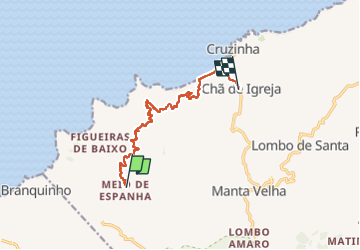
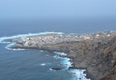
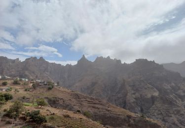
Randonnée Marche de 15,3 km à découvrir à Inconnu, Ribeira Grande. Cette randonnée est proposée par rprotte.
Description
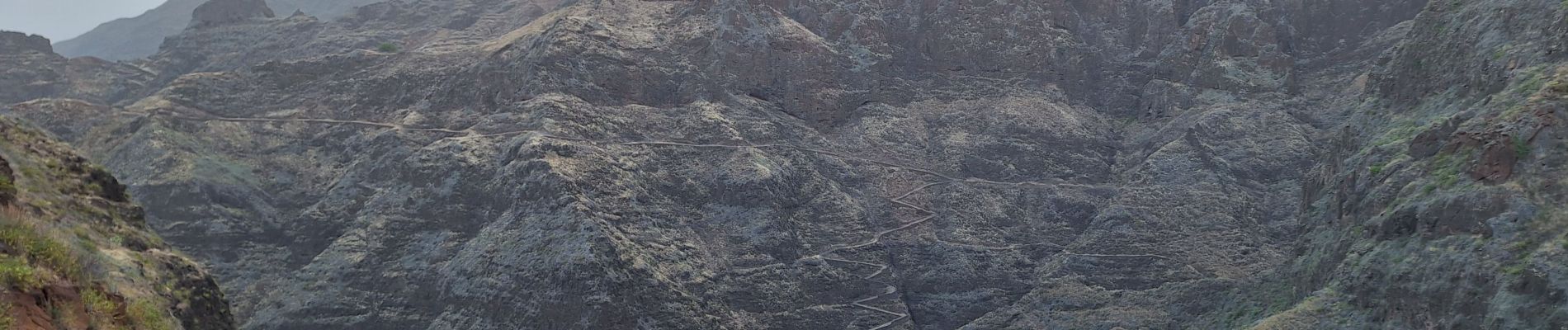
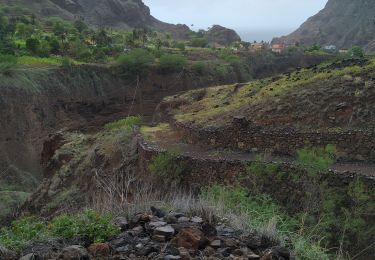
3 cols à passer avec une grosse décente de 60o de dénivelé. Pas facile la randonnée ! la fin 1 km sur la côte dans les gros pavés pas le top. mais encore une fois slendide
bug sur les Dénivelés il dit y avoir 900 de positif, pas plus
Localisation
Pays :
Cap-vert
Région :
Inconnu
Département/Province :
Ribeira Grande
Commune :
Unknown
Localité :
Unknown
Départ:(Dec)
Départ:(UTM)
691216 ; 1894231 (26Q) N.
Commentaires
Randonnées à proximité
![Randonnée A pied - Chã de Igreja - Boca de Ambas Ribeiras - Photo](https://media.geolcdn.com/t/375/260/ext.jpg?maxdim=2&url=https%3A%2F%2Fstatic1.geolcdn.com%2Fsiteimages%2Fupload%2Ffiles%2F1545311037marcheuse_200dpi.jpg)
![A pied A pied](https://static1.geolcdn.com/sitytour/trail-icons/100.png)
Chã de Igreja - Boca de Ambas Ribeiras
A pied
Moyen
(1)
,
Inconnu,
Ribeira Grande,
Cap-vert
![](/images/other/stat-length.png)
7 km | 15,8 km-effort
3h 0min
![](https://static1.geolcdn.com/siteimages/upload/files/16400158638029165_repeat_loop_refresh_sync_direction_icon.png)
Non
![Randonnée Marche - chã de igreja ponta do sol - Photo](https://media.geolcdn.com/t/375/260/adaed0a5-6c28-4afe-b823-9afc9e37e7f3.jpg&format=jpg&maxdim=2)
![Marche Marche](https://static1.geolcdn.com/sitytour/trail-icons/101.png)
chã de igreja ponta do sol
Marche
Très difficile
,
Inconnu,
Ribeira Grande,
Cap-vert
![](/images/other/stat-length.png)
17,7 km | 37 km-effort
5h 30min
![](https://static1.geolcdn.com/siteimages/upload/files/16400158638029165_repeat_loop_refresh_sync_direction_icon.png)
Non
![Randonnée Marche - Cha de Igreja - Boca de Coruja - Photo](https://media.geolcdn.com/t/375/260/a6b93792-c027-43b2-995b-2ebbb0461853.jpg&format=jpg&maxdim=2)
![Marche Marche](https://static1.geolcdn.com/sitytour/trail-icons/101.png)
Cha de Igreja - Boca de Coruja
Marche
Moyen
,
Inconnu,
Ribeira Grande,
Cap-vert
![](/images/other/stat-length.png)
9,7 km | 18,4 km-effort
3h 52min
![](https://static1.geolcdn.com/siteimages/upload/files/16400158638029165_repeat_loop_refresh_sync_direction_icon.png)
Non
![Randonnée Marche - Cap vert 7 - Photo](https://media.geolcdn.com/t/375/260/d91f76f2-63cd-4c24-a448-e3186390395d.jpg&format=jpg&maxdim=2)
![Marche Marche](https://static1.geolcdn.com/sitytour/trail-icons/101.png)
Cap vert 7
Marche
Très difficile
,
Inconnu,
Ribeira Grande,
Cap-vert
![](/images/other/stat-length.png)
19 km | 35 km-effort
22h 53min
![](https://static1.geolcdn.com/siteimages/upload/files/16400158638029165_repeat_loop_refresh_sync_direction_icon.png)
Non
![Randonnée Marche - ponta do sol kustwandeling - Photo](https://media.geolcdn.com/t/375/260/ext.jpg?maxdim=2&url=https%3A%2F%2Fstatic1.geolcdn.com%2Fsiteimages%2Fupload%2Ffiles%2F1553511878bg_sport_marche.png)
![Marche Marche](https://static1.geolcdn.com/sitytour/trail-icons/101.png)
ponta do sol kustwandeling
Marche
Moyen
,
Inconnu,
Ribeira Grande,
Cap-vert
![](/images/other/stat-length.png)
17 km | 35 km-effort
7h 13min
![](https://static1.geolcdn.com/siteimages/upload/files/16400158638029165_repeat_loop_refresh_sync_direction_icon.png)
Non
![Randonnée Marche - CV5 Manta Vielha / Alto Mira III - Photo](https://media.geolcdn.com/t/375/260/ext.jpg?maxdim=2&url=https%3A%2F%2Fstatic1.geolcdn.com%2Fsiteimages%2Fupload%2Ffiles%2F1553511878bg_sport_marche.png)
![Marche Marche](https://static1.geolcdn.com/sitytour/trail-icons/101.png)
CV5 Manta Vielha / Alto Mira III
Marche
Difficile
,
Inconnu,
Ribeira Grande,
Cap-vert
![](/images/other/stat-length.png)
17,6 km | 38 km-effort
8h 11min
![](https://static1.geolcdn.com/siteimages/upload/files/16400158638029165_repeat_loop_refresh_sync_direction_icon.png)
Non
![Randonnée Marche - Days 3&4 Cap Vert - Photo](https://media.geolcdn.com/t/375/260/ext.jpg?maxdim=2&url=https%3A%2F%2Fstatic1.geolcdn.com%2Fsiteimages%2Fupload%2Ffiles%2F1553511878bg_sport_marche.png)
![Marche Marche](https://static1.geolcdn.com/sitytour/trail-icons/101.png)
Days 3&4 Cap Vert
Marche
Très difficile
,
Inconnu,
Ribeira Grande,
Cap-vert
![](/images/other/stat-length.png)
34 km | 74 km-effort
12h 0min
![](https://static1.geolcdn.com/siteimages/upload/files/16400158638029165_repeat_loop_refresh_sync_direction_icon.png)
Non
![Randonnée Marche - Cap-Vert 4 - Photo](https://media.geolcdn.com/t/375/260/ext.jpg?maxdim=2&url=https%3A%2F%2Fstatic1.geolcdn.com%2Fsiteimages%2Fupload%2Ffiles%2F1553511878bg_sport_marche.png)
![Marche Marche](https://static1.geolcdn.com/sitytour/trail-icons/101.png)
Cap-Vert 4
Marche
Très facile
,
Inconnu,
Ribeira Grande,
Cap-vert
![](/images/other/stat-length.png)
17,1 km | 35 km-effort
6h 8min
![](https://static1.geolcdn.com/siteimages/upload/files/16400158638029165_repeat_loop_refresh_sync_direction_icon.png)
Non
![Randonnée Marche - cap vert j7 - Photo](https://media.geolcdn.com/t/375/260/ext.jpg?maxdim=2&url=https%3A%2F%2Fstatic1.geolcdn.com%2Fsiteimages%2Fupload%2Ffiles%2F1553511878bg_sport_marche.png)
![Marche Marche](https://static1.geolcdn.com/sitytour/trail-icons/101.png)