![](/images/other/stat-length.png)
![Randonnée Marche Aumont-en-Halatte - Aumont en Halatte_mare du mont Alta_Trace GPS simplifiée_8,7km - Photo](https://media.geolcdn.com/t/1900/400/ext.pjpeg?maxdim=2&url=https%3A%2F%2Fstatic1.geolcdn.com%2Fsiteimages%2Fupload%2Ffiles%2F1553511878bg_sport_marche.png)
Aumont en Halatte_mare du mont Alta_Trace GPS simplifiée_8,7km
Pousscailleux
Utilisateur
![Longueur](/images/other/stat-length.png)
Longueur
8,7 km
![Altitude max](https://static1.geolcdn.com/siteimages/upload/files/1508320355ic_sort_altitude_max_24dp.png)
Altitude max
148 m
![Dénivelé positif](https://static1.geolcdn.com/siteimages/upload/files/1508320355ic_sort_den_pos_24dp.png)
Dénivelé positif
137 m
![Km-Effort](/images/other/stat-length.png)
Km-Effort
10,5 km
![Altitude min](https://static1.geolcdn.com/siteimages/upload/files/1508320355ic_sort_altitude_min_24dp.png)
Altitude min
104 m
![Dénivelé négatif](https://static1.geolcdn.com/siteimages/upload/files/1508320355ic_sort_den_neg_24dp.png)
Dénivelé négatif
140 m
![Boucle](https://static1.geolcdn.com/siteimages/upload/files/16400158638029165_repeat_loop_refresh_sync_direction_icon.png)
Boucle
Oui
Date de création :
2015-03-14 00:00:00.0
Dernière modification :
2015-03-14 00:00:00.0
![Marche](https://static1.geolcdn.com/sitytour/trail-icons/101.png)
2h18
Difficulté : Difficile
![Scannez ce code QR pour ouvrir la randonnée dans l'application SityTrail](https://capi.geolives.com/qq0zvz2zws4bq2lad0pu/sitytour/trails/395679/qr.png?size=200)
Application GPS de randonnée GRATUITE
À propos
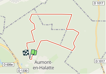
Randonnée Marche de 8,7 km à découvrir à Hauts-de-France, Oise, Aumont-en-Halatte. Cette randonnée est proposée par Pousscailleux.
Description
Départ du parking de l'ancienne carrière à l'entrée d'Aumont.
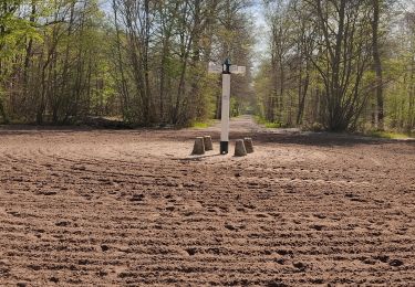
Beaucoup de sentiers défoncés, à la limite du praticable.
Localisation
Pays :
France
Région :
Hauts-de-France
Département/Province :
Oise
Commune :
Aumont-en-Halatte
Localité :
Unknown
Départ:(Dec)
Départ:(UTM)
466965 ; 5453286 (31U) N.
Commentaires
Randonnées à proximité
![Randonnée A pied Senlis - SENLIS CITE ROYALE (FFK) - Photo](https://media.geolcdn.com/t/375/260/542124cb-4295-4676-8208-e617d363b61b.jpg&format=jpg&maxdim=2)
![A pied A pied](https://static1.geolcdn.com/sitytour/trail-icons/100.png)
SENLIS CITE ROYALE (FFK)
A pied
Très facile
(1)
Senlis,
Hauts-de-France,
Oise,
France
![](/images/other/stat-length.png)
4,6 km | 5,2 km-effort
2h 0min
![](https://static1.geolcdn.com/siteimages/upload/files/16400158638029165_repeat_loop_refresh_sync_direction_icon.png)
Oui
![Randonnée Marche Fleurines - Fleurines Grand parcours - Photo](https://media.geolcdn.com/t/375/260/ext.jpg?maxdim=2&url=https%3A%2F%2Fstatic1.geolcdn.com%2Fsiteimages%2Fupload%2Ffiles%2F1553511878bg_sport_marche.png)
![Marche Marche](https://static1.geolcdn.com/sitytour/trail-icons/101.png)
Fleurines Grand parcours
Marche
Facile
(1)
Fleurines,
Hauts-de-France,
Oise,
France
![](/images/other/stat-length.png)
20 km | 24 km-effort
5h 8min
![](https://static1.geolcdn.com/siteimages/upload/files/16400158638029165_repeat_loop_refresh_sync_direction_icon.png)
Oui
![Randonnée Marche Apremont - apremont 60300 - Photo](https://media.geolcdn.com/t/375/260/ext.jpg?maxdim=2&url=https%3A%2F%2Fstatic1.geolcdn.com%2Fsiteimages%2Fupload%2Ffiles%2F1553511878bg_sport_marche.png)
![Marche Marche](https://static1.geolcdn.com/sitytour/trail-icons/101.png)
apremont 60300
Marche
Difficile
(1)
Apremont,
Hauts-de-France,
Oise,
France
![](/images/other/stat-length.png)
20 km | 23 km-effort
4h 49min
![](https://static1.geolcdn.com/siteimages/upload/files/16400158638029165_repeat_loop_refresh_sync_direction_icon.png)
Oui
![Randonnée Marche Chamant - Chamant Supermini-rando - Photo](https://media.geolcdn.com/t/375/260/ext.jpg?maxdim=2&url=https%3A%2F%2Fstatic1.geolcdn.com%2Fsiteimages%2Fupload%2Ffiles%2F1553511878bg_sport_marche.png)
![Marche Marche](https://static1.geolcdn.com/sitytour/trail-icons/101.png)
Chamant Supermini-rando
Marche
Facile
(8)
Chamant,
Hauts-de-France,
Oise,
France
![](/images/other/stat-length.png)
8 km | 9,3 km-effort
2h 7min
![](https://static1.geolcdn.com/siteimages/upload/files/16400158638029165_repeat_loop_refresh_sync_direction_icon.png)
Oui
![Randonnée A pied Senlis - De Orrouy à Coye - Photo](https://media.geolcdn.com/t/375/260/e89a52f7-2fff-43c2-bfe0-60f4f3ab03ed.jpeg&format=jpg&maxdim=2)
![A pied A pied](https://static1.geolcdn.com/sitytour/trail-icons/100.png)
De Orrouy à Coye
A pied
Facile
Senlis,
Hauts-de-France,
Oise,
France
![](/images/other/stat-length.png)
10,1 km | 11,2 km-effort
2h 33min
![](https://static1.geolcdn.com/siteimages/upload/files/16400158638029165_repeat_loop_refresh_sync_direction_icon.png)
Non
![Randonnée A pied Aumont-en-Halatte - Chemin Royal - Photo](https://media.geolcdn.com/t/375/260/907ab66a-aaa0-42f5-ab5c-59c4bff36344.jpeg&format=jpg&maxdim=2)
![A pied A pied](https://static1.geolcdn.com/sitytour/trail-icons/100.png)
Chemin Royal
A pied
Facile
Aumont-en-Halatte,
Hauts-de-France,
Oise,
France
![](/images/other/stat-length.png)
3,5 km | 4 km-effort
54min
![](https://static1.geolcdn.com/siteimages/upload/files/16400158638029165_repeat_loop_refresh_sync_direction_icon.png)
Non
![Randonnée Marche Avilly-Saint-Léonard - randonnée en forêt de chantilly - Photo](https://media.geolcdn.com/t/375/260/894a9e1d-f62c-46d6-99e6-d69f4625313f.jpg&format=jpg&maxdim=2)
![Marche Marche](https://static1.geolcdn.com/sitytour/trail-icons/101.png)
randonnée en forêt de chantilly
Marche
Très facile
Avilly-Saint-Léonard,
Hauts-de-France,
Oise,
France
![](/images/other/stat-length.png)
12,1 km | 13,2 km-effort
2h 54min
![](https://static1.geolcdn.com/siteimages/upload/files/16400158638029165_repeat_loop_refresh_sync_direction_icon.png)
Oui
![Randonnée Marche Fleurines - Fleurines_StChristophe_12,7 km_Trace GPS - Photo](https://media.geolcdn.com/t/375/260/ext.jpg?maxdim=2&url=https%3A%2F%2Fstatic1.geolcdn.com%2Fsiteimages%2Fupload%2Ffiles%2F1553511878bg_sport_marche.png)
![Marche Marche](https://static1.geolcdn.com/sitytour/trail-icons/101.png)
Fleurines_StChristophe_12,7 km_Trace GPS
Marche
Moyen
(1)
Fleurines,
Hauts-de-France,
Oise,
France
![](/images/other/stat-length.png)
12,7 km | 15,6 km-effort
2h 42min
![](https://static1.geolcdn.com/siteimages/upload/files/16400158638029165_repeat_loop_refresh_sync_direction_icon.png)
Oui
![Randonnée V.T.T. Chantilly - Dans la forêt de Chantilly - Photo](https://media.geolcdn.com/t/375/260/ext.jpg?maxdim=2&url=https%3A%2F%2Fservices.sitytrail.com%2FGeolivesWS%2FDownloadMedia.ashx%3FTrailID%3D107596%26Media%3D12557_6.jpg)
![V.T.T. V.T.T.](https://static1.geolcdn.com/sitytour/trail-icons/202.png)
Dans la forêt de Chantilly
V.T.T.
Moyen
Chantilly,
Hauts-de-France,
Oise,
France
![](/images/other/stat-length.png)
19,7 km | 22 km-effort
1h 30min
![](https://static1.geolcdn.com/siteimages/upload/files/16400158638029165_repeat_loop_refresh_sync_direction_icon.png)
Oui