![](/images/other/stat-length.png)
![Randonnée Marche Chaumes-en-Brie - Boucle les chaumes en Brie - Photo](https://media.geolcdn.com/t/1900/400/ext.pjpeg?maxdim=2&url=https%3A%2F%2Fstatic1.geolcdn.com%2Fsiteimages%2Fupload%2Ffiles%2F1553511878bg_sport_marche.png)
Boucle les chaumes en Brie
Randos du mercredi
Le mercredi c'est rando
![Longueur](/images/other/stat-length.png)
Longueur
9 km
![Altitude max](https://static1.geolcdn.com/siteimages/upload/files/1508320355ic_sort_altitude_max_24dp.png)
Altitude max
111 m
![Dénivelé positif](https://static1.geolcdn.com/siteimages/upload/files/1508320355ic_sort_den_pos_24dp.png)
Dénivelé positif
91 m
![Km-Effort](/images/other/stat-length.png)
Km-Effort
10,3 km
![Altitude min](https://static1.geolcdn.com/siteimages/upload/files/1508320355ic_sort_altitude_min_24dp.png)
Altitude min
79 m
![Dénivelé négatif](https://static1.geolcdn.com/siteimages/upload/files/1508320355ic_sort_den_neg_24dp.png)
Dénivelé négatif
94 m
![Boucle](https://static1.geolcdn.com/siteimages/upload/files/16400158638029165_repeat_loop_refresh_sync_direction_icon.png)
Boucle
Oui
Date de création :
2024-02-19 09:30:43.415
Dernière modification :
2024-02-19 09:32:36.522
![Marche](https://static1.geolcdn.com/sitytour/trail-icons/101.png)
2h19
Difficulté : Moyen
![Scannez ce code QR pour ouvrir la randonnée dans l'application SityTrail](https://capi.geolives.com/qq0zvz2zws4bq2lad0pu/sitytour/trails/3954994/qr.png?size=200)
Application GPS de randonnée GRATUITE
À propos
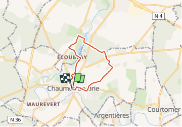
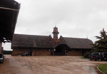
Randonnée Marche de 9 km à découvrir à Île-de-France, Seine-et-Marne, Chaumes-en-Brie. Cette randonnée est proposée par Randos du mercredi.
Description
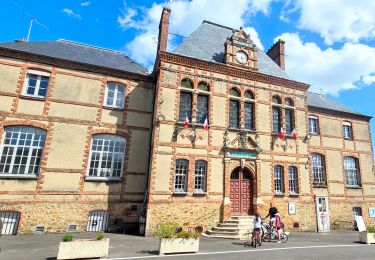
marche AM au départ de Parking 6 chemin de l'Abbaye - Les Chaumes en Brie
Localisation
Pays :
France
Région :
Île-de-France
Département/Province :
Seine-et-Marne
Commune :
Chaumes-en-Brie
Localité :
Unknown
Départ:(Dec)
Départ:(UTM)
488347 ; 5390133 (31U) N.
Commentaires
Randonnées à proximité
![Randonnée Marche Chaumes-en-Brie - Boucle 19 km Chaumes en Brie - Photo](https://media.geolcdn.com/t/375/260/70ebe8e4-d694-4301-a1eb-7913d93071d0.jpg&format=jpg&maxdim=2)
![Marche Marche](https://static1.geolcdn.com/sitytour/trail-icons/101.png)
Boucle 19 km Chaumes en Brie
Marche
Facile
Chaumes-en-Brie,
Île-de-France,
Seine-et-Marne,
France
![](/images/other/stat-length.png)
19,4 km | 22 km-effort
5h 1min
![](https://static1.geolcdn.com/siteimages/upload/files/16400158638029165_repeat_loop_refresh_sync_direction_icon.png)
Oui
![Randonnée Marche Courtomer - Boucle Courtomer - chaumes en Brie - - Photo](https://media.geolcdn.com/t/375/260/4c724cf3-58fd-4de3-a054-aacb416cef6c.jpg&format=jpg&maxdim=2)
![Marche Marche](https://static1.geolcdn.com/sitytour/trail-icons/101.png)
Boucle Courtomer - chaumes en Brie -
Marche
Facile
Courtomer,
Île-de-France,
Seine-et-Marne,
France
![](/images/other/stat-length.png)
20 km | 23 km-effort
4h 34min
![](https://static1.geolcdn.com/siteimages/upload/files/16400158638029165_repeat_loop_refresh_sync_direction_icon.png)
Oui
![Randonnée Marche Verneuil-l'Étang - Le tour du grand Paris via le GR1 Etape 12 Verneuil l'Etang- Melun - Photo](https://media.geolcdn.com/t/375/260/6eafa918-5fdc-42fa-bc25-a87386eaf61a.jpg&format=jpg&maxdim=2)
![Marche Marche](https://static1.geolcdn.com/sitytour/trail-icons/101.png)
Le tour du grand Paris via le GR1 Etape 12 Verneuil l'Etang- Melun
Marche
Moyen
Verneuil-l'Étang,
Île-de-France,
Seine-et-Marne,
France
![](/images/other/stat-length.png)
36 km | 40 km-effort
6h 55min
![](https://static1.geolcdn.com/siteimages/upload/files/16400158638029165_repeat_loop_refresh_sync_direction_icon.png)
Non
![Randonnée Marche Chaumes-en-Brie - Châteaux autour de Chaumes en Brie - Photo](https://media.geolcdn.com/t/375/260/b226bf3c-9615-49c1-add8-5b1647e725de.jpg&format=jpg&maxdim=2)
![Marche Marche](https://static1.geolcdn.com/sitytour/trail-icons/101.png)
Châteaux autour de Chaumes en Brie
Marche
Facile
Chaumes-en-Brie,
Île-de-France,
Seine-et-Marne,
France
![](/images/other/stat-length.png)
26 km | 28 km-effort
6h 21min
![](https://static1.geolcdn.com/siteimages/upload/files/16400158638029165_repeat_loop_refresh_sync_direction_icon.png)
Oui
![Randonnée Marche Chaumes-en-Brie - Chaumes-en-Brie SR190323 CRI040623 300922fmg - Photo](https://media.geolcdn.com/t/375/260/ext.jpg?maxdim=2&url=https%3A%2F%2Fstatic1.geolcdn.com%2Fsiteimages%2Fupload%2Ffiles%2F1553511878bg_sport_marche.png)
![Marche Marche](https://static1.geolcdn.com/sitytour/trail-icons/101.png)
Chaumes-en-Brie SR190323 CRI040623 300922fmg
Marche
Très difficile
(1)
Chaumes-en-Brie,
Île-de-France,
Seine-et-Marne,
France
![](/images/other/stat-length.png)
22 km | 26 km-effort
5h 48min
![](https://static1.geolcdn.com/siteimages/upload/files/16400158638029165_repeat_loop_refresh_sync_direction_icon.png)
Oui
![Randonnée Marche Ozouer-le-Voulgis - autour? - Photo](https://media.geolcdn.com/t/375/260/97cebebb-fdbb-4139-b072-b3a92a132a3a.jpg&format=jpg&maxdim=2)
![Marche Marche](https://static1.geolcdn.com/sitytour/trail-icons/101.png)
autour?
Marche
Très facile
Ozouer-le-Voulgis,
Île-de-France,
Seine-et-Marne,
France
![](/images/other/stat-length.png)
6,3 km | 7,1 km-effort
3h 16min
![](https://static1.geolcdn.com/siteimages/upload/files/16400158638029165_repeat_loop_refresh_sync_direction_icon.png)
Non
![Randonnée Marche Chaumes-en-Brie - La ferme de Forest 2 - Photo](https://media.geolcdn.com/t/375/260/ext.jpg?maxdim=2&url=https%3A%2F%2Fstatic1.geolcdn.com%2Fsiteimages%2Fupload%2Ffiles%2F1553511878bg_sport_marche.png)
![Marche Marche](https://static1.geolcdn.com/sitytour/trail-icons/101.png)
La ferme de Forest 2
Marche
Facile
(1)
Chaumes-en-Brie,
Île-de-France,
Seine-et-Marne,
France
![](/images/other/stat-length.png)
11,3 km | 13 km-effort
3h 25min
![](https://static1.geolcdn.com/siteimages/upload/files/16400158638029165_repeat_loop_refresh_sync_direction_icon.png)
Oui
![Randonnée Marche Chaumes-en-Brie - Autour de CHAUMES en BRIE - Photo](https://media.geolcdn.com/t/375/260/27579921-6113-4a63-a05a-e95624baef28.jpg&format=jpg&maxdim=2)
![Marche Marche](https://static1.geolcdn.com/sitytour/trail-icons/101.png)
Autour de CHAUMES en BRIE
Marche
Moyen
Chaumes-en-Brie,
Île-de-France,
Seine-et-Marne,
France
![](/images/other/stat-length.png)
21 km | 23 km-effort
5h 0min
![](https://static1.geolcdn.com/siteimages/upload/files/16400158638029165_repeat_loop_refresh_sync_direction_icon.png)
Oui
![Randonnée Marche Chaumes-en-Brie - Chaumes'Yerres - Photo](https://media.geolcdn.com/t/375/260/ext.jpg?maxdim=2&url=https%3A%2F%2Fservices.sitytrail.com%2FGeolivesWS%2FDownloadMedia.ashx%3FTrailID%3D415743%26Media%3Dccd14579-d4e0-494c-9820-adb9307e2c19.jpg)
![Marche Marche](https://static1.geolcdn.com/sitytour/trail-icons/101.png)
Chaumes'Yerres
Marche
Moyen
Chaumes-en-Brie,
Île-de-France,
Seine-et-Marne,
France
![](/images/other/stat-length.png)
23 km | 26 km-effort
5h 35min
![](https://static1.geolcdn.com/siteimages/upload/files/16400158638029165_repeat_loop_refresh_sync_direction_icon.png)
Oui