![](/images/other/stat-length.png)
![Randonnée Marche Prunet-et-Belpuig - Boule d'amont, à la chapelle de La Trinité. - Photo](https://media.geolcdn.com/t/1900/400/ext.pjpeg?maxdim=2&url=https%3A%2F%2Fstatic1.geolcdn.com%2Fsiteimages%2Fupload%2Ffiles%2F1553511878bg_sport_marche.png)
Boule d'amont, à la chapelle de La Trinité.
Santblasi
Utilisateur
![Longueur](/images/other/stat-length.png)
Longueur
12,9 km
![Altitude max](https://static1.geolcdn.com/siteimages/upload/files/1508320355ic_sort_altitude_max_24dp.png)
Altitude max
760 m
![Dénivelé positif](https://static1.geolcdn.com/siteimages/upload/files/1508320355ic_sort_den_pos_24dp.png)
Dénivelé positif
421 m
![Km-Effort](/images/other/stat-length.png)
Km-Effort
18,5 km
![Altitude min](https://static1.geolcdn.com/siteimages/upload/files/1508320355ic_sort_altitude_min_24dp.png)
Altitude min
408 m
![Dénivelé négatif](https://static1.geolcdn.com/siteimages/upload/files/1508320355ic_sort_den_neg_24dp.png)
Dénivelé négatif
421 m
![Boucle](https://static1.geolcdn.com/siteimages/upload/files/16400158638029165_repeat_loop_refresh_sync_direction_icon.png)
Boucle
Oui
Date de création :
2024-02-18 08:14:07.888
Dernière modification :
2024-02-18 18:27:24.43
![Marche](https://static1.geolcdn.com/sitytour/trail-icons/101.png)
3h40
Difficulté : Facile
![Scannez ce code QR pour ouvrir la randonnée dans l'application SityTrail](https://capi.geolives.com/qq0zvz2zws4bq2lad0pu/sitytour/trails/3954650/qr.png?size=200)
Application GPS de randonnée GRATUITE
À propos
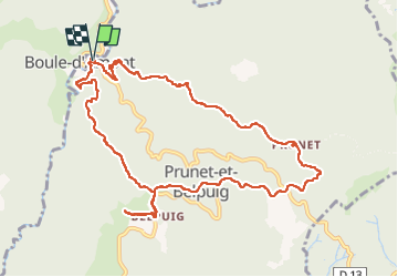
Randonnée Marche de 12,9 km à découvrir à Occitanie, Pyrénées-Orientales, Prunet-et-Belpuig. Cette randonnée est proposée par Santblasi.
Description
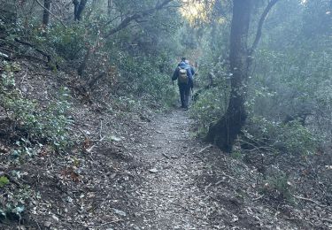
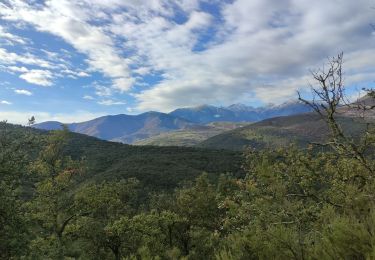
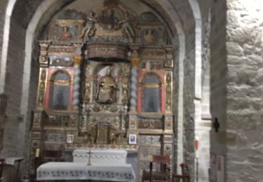
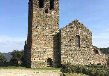
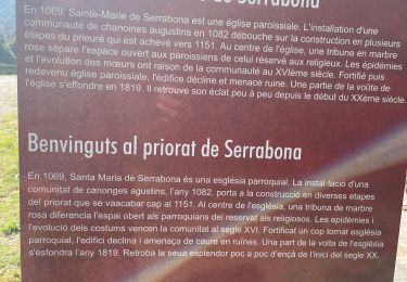
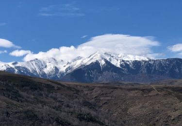
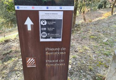
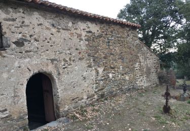
randonnée en forêt sur pistes DFCI, belles vues sur les massifs du Canigou et du Madres. Passage par plusieurs chapelles.
À La Trinité, vues à 360 degrés, mer et montagne.
Localisation
Pays :
France
Région :
Occitanie
Département/Province :
Pyrénées-Orientales
Commune :
Prunet-et-Belpuig
Localité :
Unknown
Départ:(Dec)
Départ:(UTM)
468492 ; 4714219 (31T) N.
Commentaires
Randonnées à proximité
![Randonnée Marche Casefabre - Casefabre 66 - Photo](https://media.geolcdn.com/t/375/260/fda5b463-42b5-4e8b-9ebd-458b38a5ec57.jpg&format=jpg&maxdim=2)
![Marche Marche](https://static1.geolcdn.com/sitytour/trail-icons/101.png)
Casefabre 66
Marche
Moyen
Casefabre,
Occitanie,
Pyrénées-Orientales,
France
![](/images/other/stat-length.png)
10,4 km | 14,8 km-effort
3h 19min
![](https://static1.geolcdn.com/siteimages/upload/files/16400158638029165_repeat_loop_refresh_sync_direction_icon.png)
Oui
![Randonnée Marche Prunet-et-Belpuig - BOULE d'AMONT - La TRINITE - Photo](https://media.geolcdn.com/t/375/260/63148342-eaf9-42f9-af5b-21ab9e845710.jpg&format=jpg&maxdim=2)
![Marche Marche](https://static1.geolcdn.com/sitytour/trail-icons/101.png)
BOULE d'AMONT - La TRINITE
Marche
Moyen
Prunet-et-Belpuig,
Occitanie,
Pyrénées-Orientales,
France
![](/images/other/stat-length.png)
12,4 km | 17 km-effort
3h 20min
![](https://static1.geolcdn.com/siteimages/upload/files/16400158638029165_repeat_loop_refresh_sync_direction_icon.png)
Oui
![Randonnée Marche Prunet-et-Belpuig - Boule d’amont /Chapelle de la Trinité / Prunet - Photo](https://media.geolcdn.com/t/375/260/68eed7a9-ae13-40d7-8c91-a7b1707b93bf.jpg&format=jpg&maxdim=2)
![Marche Marche](https://static1.geolcdn.com/sitytour/trail-icons/101.png)
Boule d’amont /Chapelle de la Trinité / Prunet
Marche
Facile
Prunet-et-Belpuig,
Occitanie,
Pyrénées-Orientales,
France
![](/images/other/stat-length.png)
11,2 km | 16 km-effort
3h 6min
![](https://static1.geolcdn.com/siteimages/upload/files/16400158638029165_repeat_loop_refresh_sync_direction_icon.png)
Oui
![Randonnée Marche Boule-d'Amont - 20240104 Tour depuis le prieuré de Serrabonne - Photo](https://media.geolcdn.com/t/375/260/a082747f-89ab-4e46-8caf-fd728589230f.jpg&format=jpg&maxdim=2)
![Marche Marche](https://static1.geolcdn.com/sitytour/trail-icons/101.png)
20240104 Tour depuis le prieuré de Serrabonne
Marche
Moyen
Boule-d'Amont,
Occitanie,
Pyrénées-Orientales,
France
![](/images/other/stat-length.png)
15,2 km | 26 km-effort
4h 37min
![](https://static1.geolcdn.com/siteimages/upload/files/16400158638029165_repeat_loop_refresh_sync_direction_icon.png)
Oui
![Randonnée Marche Boule-d'Amont - Serrabone /le roc rouge(le rocher du dragon):itinéraire 2 - Photo](https://media.geolcdn.com/t/375/260/26b43676-9e75-4b0d-befc-d44645d8fbe1.jpg&format=jpg&maxdim=2)
![Marche Marche](https://static1.geolcdn.com/sitytour/trail-icons/101.png)
Serrabone /le roc rouge(le rocher du dragon):itinéraire 2
Marche
Moyen
Boule-d'Amont,
Occitanie,
Pyrénées-Orientales,
France
![](/images/other/stat-length.png)
10,1 km | 17,5 km-effort
3h 32min
![](https://static1.geolcdn.com/siteimages/upload/files/16400158638029165_repeat_loop_refresh_sync_direction_icon.png)
Oui
![Randonnée Marche Boule-d'Amont - Serra une - Photo](https://media.geolcdn.com/t/375/260/40936afc-9b58-415d-9be4-e3356895329e.jpg&format=jpg&maxdim=2)
![Marche Marche](https://static1.geolcdn.com/sitytour/trail-icons/101.png)
Serra une
Marche
Moyen
Boule-d'Amont,
Occitanie,
Pyrénées-Orientales,
France
![](/images/other/stat-length.png)
10,4 km | 17,8 km-effort
3h 44min
![](https://static1.geolcdn.com/siteimages/upload/files/16400158638029165_repeat_loop_refresh_sync_direction_icon.png)
Oui
![Randonnée Marche Boule-d'Amont - 20210321 Boule d’Amont - Serrabone - Photo](https://media.geolcdn.com/t/375/260/16b44598-e6b8-4fe8-87e4-5112a1cd140b.jpg&format=jpg&maxdim=2)
![Marche Marche](https://static1.geolcdn.com/sitytour/trail-icons/101.png)
20210321 Boule d’Amont - Serrabone
Marche
Moyen
Boule-d'Amont,
Occitanie,
Pyrénées-Orientales,
France
![](/images/other/stat-length.png)
13,4 km | 23 km-effort
3h 58min
![](https://static1.geolcdn.com/siteimages/upload/files/16400158638029165_repeat_loop_refresh_sync_direction_icon.png)
Oui
![Randonnée Marche Boule-d'Amont - Serrabonne autour du prieuré - Photo](https://media.geolcdn.com/t/375/260/24231eed-2f48-4061-8c52-7dd0f6f55a72.jpg&format=jpg&maxdim=2)
![Marche Marche](https://static1.geolcdn.com/sitytour/trail-icons/101.png)
Serrabonne autour du prieuré
Marche
Moyen
Boule-d'Amont,
Occitanie,
Pyrénées-Orientales,
France
![](/images/other/stat-length.png)
9,3 km | 16,2 km-effort
4h 27min
![](https://static1.geolcdn.com/siteimages/upload/files/16400158638029165_repeat_loop_refresh_sync_direction_icon.png)
Oui
![Randonnée Marche Caixas - Fontcouverte 3 chapelles - Photo](https://media.geolcdn.com/t/375/260/af49db35-9ffa-47e6-b836-be8e544cfc79.jpg&format=jpg&maxdim=2)
![Marche Marche](https://static1.geolcdn.com/sitytour/trail-icons/101.png)
Fontcouverte 3 chapelles
Marche
Difficile
Caixas,
Occitanie,
Pyrénées-Orientales,
France
![](/images/other/stat-length.png)
28 km | 38 km-effort
3h 46min
![](https://static1.geolcdn.com/siteimages/upload/files/16400158638029165_repeat_loop_refresh_sync_direction_icon.png)
Non