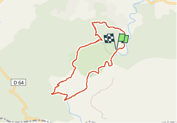
![](/images/other/stat-length.png)
![Randonnée Marche Tourves - SityTrail - les gorges du carami - Photo](https://media.geolcdn.com/t/1900/400/ext.pjpeg?maxdim=2&url=https%3A%2F%2Fstatic1.geolcdn.com%2Fsiteimages%2Fupload%2Ffiles%2F1553511878bg_sport_marche.png)
SityTrail - les gorges du carami
cazi
Utilisateur
![Longueur](/images/other/stat-length.png)
![Altitude max](https://static1.geolcdn.com/siteimages/upload/files/1508320355ic_sort_altitude_max_24dp.png)
![Dénivelé positif](https://static1.geolcdn.com/siteimages/upload/files/1508320355ic_sort_den_pos_24dp.png)
![Km-Effort](/images/other/stat-length.png)
![Altitude min](https://static1.geolcdn.com/siteimages/upload/files/1508320355ic_sort_altitude_min_24dp.png)
![Dénivelé négatif](https://static1.geolcdn.com/siteimages/upload/files/1508320355ic_sort_den_neg_24dp.png)
![Boucle](https://static1.geolcdn.com/siteimages/upload/files/16400158638029165_repeat_loop_refresh_sync_direction_icon.png)
![Marche](https://static1.geolcdn.com/sitytour/trail-icons/101.png)
2h50
Difficulté : Difficile
![Scannez ce code QR pour ouvrir la randonnée dans l'application SityTrail](https://capi.geolives.com/qq0zvz2zws4bq2lad0pu/sitytour/trails/3952294/qr.png?size=200)
Application GPS de randonnée GRATUITE
À propos
Randonnée Marche de 8,8 km à découvrir à Provence-Alpes-Côte d'Azur, Var, Tourves. Cette randonnée est proposée par cazi.
Description
depart depuis le parking des gorges (attention la route est étroite et en saison c'est compliqué pour y aller) petite montée avec une vue dégagée au niveau de la chapelle saint probace.Ensuite descente tranquille vers le carami et piquenique sur des petites plages bien sympa et enfin retour au parking en longeant le carami.
Localisation
Commentaires
Randonnées à proximité
![Randonnée Marche Mazaugues - Mazaugues 21.4.24 - Photo](https://media.geolcdn.com/t/375/260/73ef7019-56c4-45d7-90ef-e1bea2022610.jpg&format=jpg&maxdim=2)
![Marche Marche](https://static1.geolcdn.com/sitytour/trail-icons/101.png)
Marche
![](/images/other/stat-length.png)
![](https://static1.geolcdn.com/siteimages/upload/files/16400158638029165_repeat_loop_refresh_sync_direction_icon.png)
![Randonnée Marche Tourves - Tourves - Les gorges du Caramy - Le Saut du Cabri - Casteleret - Grotte Chuchy - St Probace - Photo](https://media.geolcdn.com/t/375/260/124cbbf2-932c-4737-ad3d-4f1fc25db1d8.jpg&format=jpg&maxdim=2)
![Marche Marche](https://static1.geolcdn.com/sitytour/trail-icons/101.png)
Marche
![](/images/other/stat-length.png)
![](https://static1.geolcdn.com/siteimages/upload/files/16400158638029165_repeat_loop_refresh_sync_direction_icon.png)
![Randonnée Marche Mazaugues - le Mourre d'Agnis au départ du Caucadis - Photo](https://media.geolcdn.com/t/375/260/dcd1794e-c5af-44e1-af91-1fadcb296c68.jpg&format=jpg&maxdim=2)
![Marche Marche](https://static1.geolcdn.com/sitytour/trail-icons/101.png)
Marche
![](/images/other/stat-length.png)
![](https://static1.geolcdn.com/siteimages/upload/files/16400158638029165_repeat_loop_refresh_sync_direction_icon.png)
![Randonnée Marche Mazaugues - Mazaugues le vallon de l'Herbette - Photo](https://media.geolcdn.com/t/375/260/62c4707c-a050-47d0-822e-64a046e156e1.jpg&format=jpg&maxdim=2)
![Marche Marche](https://static1.geolcdn.com/sitytour/trail-icons/101.png)
Marche
![](/images/other/stat-length.png)
![](https://static1.geolcdn.com/siteimages/upload/files/16400158638029165_repeat_loop_refresh_sync_direction_icon.png)
![Randonnée Marche Tourves - chapelle Saint Probace et gorges du caramy - Photo](https://media.geolcdn.com/t/375/260/ext.jpg?maxdim=2&url=https%3A%2F%2Fservices.sitytrail.com%2FGeolivesWS%2FDownloadMedia.ashx%3FTrailID%3D984279%26Media%3Dfix__20180610150603.jpg)
![Marche Marche](https://static1.geolcdn.com/sitytour/trail-icons/101.png)
Marche
![](/images/other/stat-length.png)
![](https://static1.geolcdn.com/siteimages/upload/files/16400158638029165_repeat_loop_refresh_sync_direction_icon.png)
![Marche Marche](https://static1.geolcdn.com/sitytour/trail-icons/101.png)
Marche
![](/images/other/stat-length.png)
![](https://static1.geolcdn.com/siteimages/upload/files/16400158638029165_repeat_loop_refresh_sync_direction_icon.png)
![Randonnée A pied Mazaugues - Mazaugues-Mourre d'Agnis-23-10-2024 - Photo](https://media.geolcdn.com/t/375/260/8bdd9a43-13c3-4a0a-a9d2-ae092f24102a.jpg&format=jpg&maxdim=2)
![A pied A pied](https://static1.geolcdn.com/sitytour/trail-icons/100.png)
A pied
![](/images/other/stat-length.png)
![](https://static1.geolcdn.com/siteimages/upload/files/16400158638029165_repeat_loop_refresh_sync_direction_icon.png)
![Randonnée Marche Mazaugues - De Mazaugues vers la glacière Pivaut - Photo](https://media.geolcdn.com/t/375/260/93cdb635-dd33-4fbf-b53a-783eebba00a2.jpg&format=jpg&maxdim=2)
![Marche Marche](https://static1.geolcdn.com/sitytour/trail-icons/101.png)
Marche
![](/images/other/stat-length.png)
![](https://static1.geolcdn.com/siteimages/upload/files/16400158638029165_repeat_loop_refresh_sync_direction_icon.png)
![Randonnée Marche Tourves - Chapelle Saint Probace-Caramy - Photo](https://media.geolcdn.com/t/375/260/7f1232ec-7969-4983-99a5-20a0dcf4a9ed.jpg&format=jpg&maxdim=2)
![Marche Marche](https://static1.geolcdn.com/sitytour/trail-icons/101.png)
Marche
![](/images/other/stat-length.png)
![](https://static1.geolcdn.com/siteimages/upload/files/16400158638029165_repeat_loop_refresh_sync_direction_icon.png)