![](/images/other/stat-length.png)
![Randonnée Marche Oupeye - 20240215 - Balade ornithologique - Hermalle 4.2 Km - Photo](https://media.geolcdn.com/t/1900/400/405b33b7-21ca-4a15-8406-0c2067e40a3a.jpeg&format=pjpeg&maxdim=2)
20240215 - Balade ornithologique - Hermalle 4.2 Km
pierreh01
Utilisateur GUIDE
![Longueur](/images/other/stat-length.png)
![Altitude max](https://static1.geolcdn.com/siteimages/upload/files/1508320355ic_sort_altitude_max_24dp.png)
![Dénivelé positif](https://static1.geolcdn.com/siteimages/upload/files/1508320355ic_sort_den_pos_24dp.png)
![Km-Effort](/images/other/stat-length.png)
![Altitude min](https://static1.geolcdn.com/siteimages/upload/files/1508320355ic_sort_altitude_min_24dp.png)
![Dénivelé négatif](https://static1.geolcdn.com/siteimages/upload/files/1508320355ic_sort_den_neg_24dp.png)
![Boucle](https://static1.geolcdn.com/siteimages/upload/files/16400158638029165_repeat_loop_refresh_sync_direction_icon.png)
![Marche](https://static1.geolcdn.com/sitytour/trail-icons/101.png)
2h43
Difficulté : Facile
![Scannez ce code QR pour ouvrir la randonnée dans l'application SityTrail](https://capi.geolives.com/qq0zvz2zws4bq2lad0pu/sitytour/trails/3950670/qr.png?size=200)
Application GPS de randonnée GRATUITE
À propos
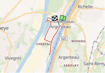
Randonnée Marche de 4,2 km à découvrir à Wallonie, Liège, Oupeye. Cette randonnée est proposée par pierreh01.
Description
Jeudi 15 février 2024 : Balade mensuelle ornithologique de l'UCTL Plateau de Herve.
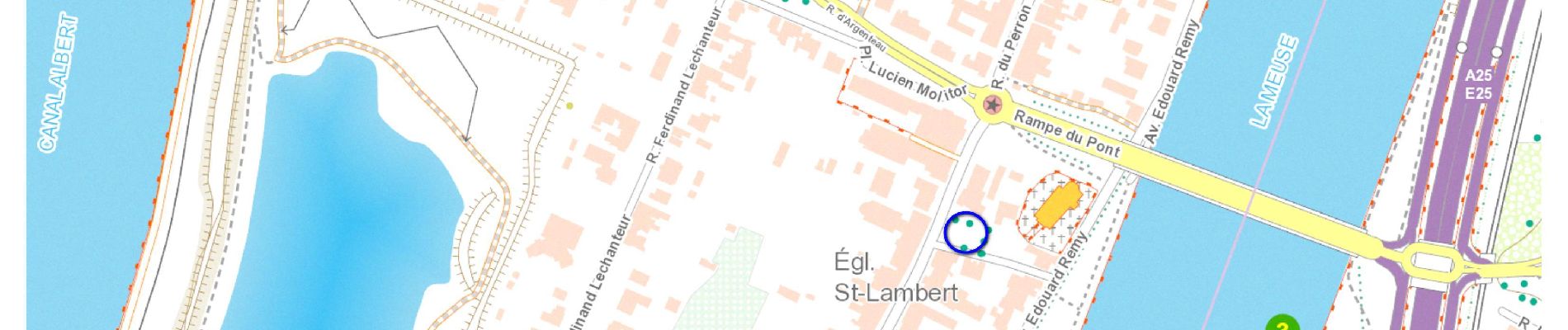
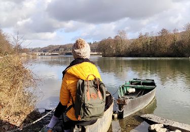
C'est sous la houlette de notre guide conférencier Roger, et sous une météo très agréable, qu'il nous a emmené à la Gravière Brockk et le Hemlot, au départ de l'église Saint Michel de Hermalle-sous-Argenteau.
Nous avons pu y voir moultes espèces, notamment des bernache du Canada, col vert, foulque, fuligule morillon, fuligule milouin, oie de Barbarie, cormoran noir, martin pêcheur, chauve-souris, tarin, goéland, tortue, pie, mésange, pigeon ramier, et d'autres oubliées.
Distance de 4,2 Km mesurée avec Sity Trail, semblant plus proche de la réalité.
Localisation
Commentaires
Randonnées à proximité
![Randonnée Marche Dalhem - dalhem Bombaye aubin mortroux dalhem - Photo](https://media.geolcdn.com/t/375/260/16a64587-f39e-4282-a4fc-c52e1169e4ec.jpg&format=jpg&maxdim=2)
![Marche Marche](https://static1.geolcdn.com/sitytour/trail-icons/101.png)
Marche
![](/images/other/stat-length.png)
![](https://static1.geolcdn.com/siteimages/upload/files/16400158638029165_repeat_loop_refresh_sync_direction_icon.png)
![Randonnée Marche Dalhem - dalhem tunnel . nelhain . la tombe . la folie. dalhrm - Photo](https://media.geolcdn.com/t/375/260/69f57071-dca8-4a6e-ab63-e929cdeb9e89.jpg&format=jpg&maxdim=2)
![Marche Marche](https://static1.geolcdn.com/sitytour/trail-icons/101.png)
Marche
![](/images/other/stat-length.png)
![](https://static1.geolcdn.com/siteimages/upload/files/16400158638029165_repeat_loop_refresh_sync_direction_icon.png)
![Randonnée Marche Visé - Hermalle - Argenteau _1489 - Photo](https://media.geolcdn.com/t/375/260/d0453d3e-7a76-47f8-90f9-7c05ed843e1f.jpg&format=jpg&maxdim=2)
![Marche Marche](https://static1.geolcdn.com/sitytour/trail-icons/101.png)
Marche
![](/images/other/stat-length.png)
![](https://static1.geolcdn.com/siteimages/upload/files/16400158638029165_repeat_loop_refresh_sync_direction_icon.png)
![Randonnée Marche Blegny - Barchon _1702 - Photo](https://media.geolcdn.com/t/375/260/08e717c2-a47c-47f0-9a4e-fb7b564b3f18.jpg&format=jpg&maxdim=2)
![Marche Marche](https://static1.geolcdn.com/sitytour/trail-icons/101.png)
Marche
![](/images/other/stat-length.png)
![](https://static1.geolcdn.com/siteimages/upload/files/16400158638029165_repeat_loop_refresh_sync_direction_icon.png)
![Randonnée Marche Blegny - 20230703 - Blegny-Mine 6.8 Km - Photo](https://media.geolcdn.com/t/375/260/840a4c96-62cb-4388-9c6c-d720f9bd1cc9.jpeg&format=jpg&maxdim=2)
![Marche Marche](https://static1.geolcdn.com/sitytour/trail-icons/101.png)
Marche
![](/images/other/stat-length.png)
![](https://static1.geolcdn.com/siteimages/upload/files/16400158638029165_repeat_loop_refresh_sync_direction_icon.png)
![Randonnée Marche Visé - Domaine de la Julienne - Photo](https://media.geolcdn.com/t/375/260/5e4777ba-1a15-488d-98c7-dac2d98d32bb.jpg&format=jpg&maxdim=2)
![Marche Marche](https://static1.geolcdn.com/sitytour/trail-icons/101.png)
Marche
![](/images/other/stat-length.png)
![](https://static1.geolcdn.com/siteimages/upload/files/16400158638029165_repeat_loop_refresh_sync_direction_icon.png)
![Randonnée Marche Oupeye - Promenade](https://media.geolcdn.com/t/375/260/4c0dc939-dd1a-4913-b8bc-ece5c8f95bc2.jpg&format=jpg&maxdim=2)
![Marche Marche](https://static1.geolcdn.com/sitytour/trail-icons/101.png)
Marche
![](/images/other/stat-length.png)
![](https://static1.geolcdn.com/siteimages/upload/files/16400158638029165_repeat_loop_refresh_sync_direction_icon.png)
![Randonnée Marche Blegny - Mortier - Photo](https://media.geolcdn.com/t/375/260/8ae971b0-94ee-4292-831a-4bed9649b36e.jpg&format=jpg&maxdim=2)
![Marche Marche](https://static1.geolcdn.com/sitytour/trail-icons/101.png)
![Randonnée Marche Dalhem - Le grand tour de Dalhem - Photo](https://media.geolcdn.com/t/375/260/4b9d5549-628f-4fae-9acb-a6fdf312b80d.jpg&format=jpg&maxdim=2)
![Marche Marche](https://static1.geolcdn.com/sitytour/trail-icons/101.png)
Marche
![](/images/other/stat-length.png)
![](https://static1.geolcdn.com/siteimages/upload/files/16400158638029165_repeat_loop_refresh_sync_direction_icon.png)