![](/images/other/stat-length.png)
![Randonnée Marche Pervenchères - Pervenchères - Le chêne de La Lambonnière 8,7 km - Photo](https://media.geolcdn.com/t/1900/400/ext.pjpeg?maxdim=2&url=https%3A%2F%2Fstatic1.geolcdn.com%2Fsiteimages%2Fupload%2Ffiles%2F1553511878bg_sport_marche.png)
Pervenchères - Le chêne de La Lambonnière 8,7 km
ODDAD78
Utilisateur
![Longueur](/images/other/stat-length.png)
![Altitude max](https://static1.geolcdn.com/siteimages/upload/files/1508320355ic_sort_altitude_max_24dp.png)
![Dénivelé positif](https://static1.geolcdn.com/siteimages/upload/files/1508320355ic_sort_den_pos_24dp.png)
![Km-Effort](/images/other/stat-length.png)
![Altitude min](https://static1.geolcdn.com/siteimages/upload/files/1508320355ic_sort_altitude_min_24dp.png)
![Dénivelé négatif](https://static1.geolcdn.com/siteimages/upload/files/1508320355ic_sort_den_neg_24dp.png)
![Boucle](https://static1.geolcdn.com/siteimages/upload/files/16400158638029165_repeat_loop_refresh_sync_direction_icon.png)
![Marche](https://static1.geolcdn.com/sitytour/trail-icons/101.png)
2h14
Difficulté : Moyen
![Scannez ce code QR pour ouvrir la randonnée dans l'application SityTrail](https://capi.geolives.com/qq0zvz2zws4bq2lad0pu/sitytour/trails/3945778/qr.png?size=200)
Application GPS de randonnée GRATUITE
À propos
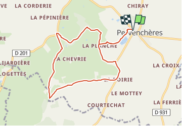
Randonnée Marche de 8,7 km à découvrir à Normandie, Orne, Pervenchères. Cette randonnée est proposée par ODDAD78.
Description
Découverte d’un chêne remarquable, plusieurs fois centenaires et de son site. Jolis points de vue et coins de pique-nique.
Partant de la place des Pervenches, le chemin longe l’étang de Pervenchères, se prolonge par un chemin ombragé jusqu’à La Lambonnière: son chêne pluricentenaire et le site consacré à la découverte de la nature. Le chemin se poursuit ensiuite vers l’entrée du Grand Refuge SPA puis par un sentier qui rejoint la route de la Haute Crête. On y découvre un beau panorama sur Pervenchères, avant d’amorcer le retour vers le bourg.
Départ / Arrivée : Pervenchères, près de l'église
Communes traversées : Pervenchères, Montgaudry
Peu après le monument aux morts, à l’extrémité de la place, prendre à gauche la rue du Vieux Chêne, menant à l’étang communal. A hauteur de Moire, continuer tout droit par un chemin en herbe, en lisière de bois.
A l’intersection bifurquer à droite, suivre un chemin en herbe. Longer une peupleraie, à son extrémité, à droite le chemin conduit au site de la Lambonnière
Prendre à gauche vers la Chevrie et le site du Grand Refuge de la SPA. Franchir le ruisseau de Belnoë. Emprunter sur la droite un chemin plus étroit. Humide par endroit ce chemin remonte à son extrémité et débouche sur une petite route goudronnée, près de la Haute Crête.
Tourner à gauche sur la route goudronnée, Les Hauts Bois, Monthodevin, le petit Monthodevin.
Au carrefour tourner à gauche sur le D 297. Les Bondes. Quitter la départementale sur la gauche pour prendre le chemin de La Planche. Continuer jusqu’au hangar au bout du chemin et prendre à droite. Revenir par l’itinéraire de départ.
Localisation
Commentaires
Randonnées à proximité
![Randonnée Marche Pervenchères - Le chêne de La Lambonnière 8,7 km - Photo](https://media.geolcdn.com/t/375/260/be123da2-77bf-4b7d-8049-3c5fe0c5807a.jpg&format=jpg&maxdim=2)
![Marche Marche](https://static1.geolcdn.com/sitytour/trail-icons/101.png)
Marche
![](/images/other/stat-length.png)
![](https://static1.geolcdn.com/siteimages/upload/files/16400158638029165_repeat_loop_refresh_sync_direction_icon.png)
![Randonnée Marche Pervenchères - Le Bois du Châtaignier 4,5 km - Photo](https://media.geolcdn.com/t/375/260/32811f16-13a1-4095-9db6-b0b4ae9783db.png&format=jpg&maxdim=2)
![Marche Marche](https://static1.geolcdn.com/sitytour/trail-icons/101.png)
Marche
![](/images/other/stat-length.png)
![](https://static1.geolcdn.com/siteimages/upload/files/16400158638029165_repeat_loop_refresh_sync_direction_icon.png)
![Randonnée Marche Pervenchères - Pervenchères - Le Bois du Châtaignier 4,5 km - Photo](https://media.geolcdn.com/t/375/260/ext.jpg?maxdim=2&url=https%3A%2F%2Fstatic1.geolcdn.com%2Fsiteimages%2Fupload%2Ffiles%2F1553511878bg_sport_marche.png)
![Marche Marche](https://static1.geolcdn.com/sitytour/trail-icons/101.png)
Marche
![](/images/other/stat-length.png)
![](https://static1.geolcdn.com/siteimages/upload/files/16400158638029165_repeat_loop_refresh_sync_direction_icon.png)
![Randonnée Marche Pervenchères - Pervenchères Bois du Chätaignier 4Km - Photo](https://media.geolcdn.com/t/375/260/ext.jpg?maxdim=2&url=https%3A%2F%2Fstatic1.geolcdn.com%2Fsiteimages%2Fupload%2Ffiles%2F1553511878bg_sport_marche.png)
![Marche Marche](https://static1.geolcdn.com/sitytour/trail-icons/101.png)
Marche
![](/images/other/stat-length.png)
![](https://static1.geolcdn.com/siteimages/upload/files/16400158638029165_repeat_loop_refresh_sync_direction_icon.png)
![Randonnée Marche Pervenchères - Boucle de Pervenchères 20Km - Photo](https://media.geolcdn.com/t/375/260/ext.jpg?maxdim=2&url=https%3A%2F%2Fstatic1.geolcdn.com%2Fsiteimages%2Fupload%2Ffiles%2F1553511878bg_sport_marche.png)
![Marche Marche](https://static1.geolcdn.com/sitytour/trail-icons/101.png)
Marche
![](/images/other/stat-length.png)
![](https://static1.geolcdn.com/siteimages/upload/files/16400158638029165_repeat_loop_refresh_sync_direction_icon.png)
![Randonnée Marche Montgaudry - Montgaudry / Contilly 9,3 Km - Photo](https://media.geolcdn.com/t/375/260/ext.jpg?maxdim=2&url=https%3A%2F%2Fstatic1.geolcdn.com%2Fsiteimages%2Fupload%2Ffiles%2F1553511878bg_sport_marche.png)
![Marche Marche](https://static1.geolcdn.com/sitytour/trail-icons/101.png)
Marche
![](/images/other/stat-length.png)
![](https://static1.geolcdn.com/siteimages/upload/files/16400158638029165_repeat_loop_refresh_sync_direction_icon.png)
![Randonnée Marche Contilly - Contilly 8,0 Km - Photo](https://media.geolcdn.com/t/375/260/ext.jpg?maxdim=2&url=https%3A%2F%2Fstatic1.geolcdn.com%2Fsiteimages%2Fupload%2Ffiles%2F1553511878bg_sport_marche.png)
![Marche Marche](https://static1.geolcdn.com/sitytour/trail-icons/101.png)
Marche
![](/images/other/stat-length.png)
![](https://static1.geolcdn.com/siteimages/upload/files/16400158638029165_repeat_loop_refresh_sync_direction_icon.png)
![Randonnée Marche Pervenchères - Pervenchère - La Lambonière 8.4 Km - Photo](https://media.geolcdn.com/t/375/260/cf86cba0-7c88-47ca-97bd-a73cecead7c6.jpg&format=jpg&maxdim=2)
![Marche Marche](https://static1.geolcdn.com/sitytour/trail-icons/101.png)
Marche
![](/images/other/stat-length.png)
![](https://static1.geolcdn.com/siteimages/upload/files/16400158638029165_repeat_loop_refresh_sync_direction_icon.png)
![Randonnée A pied Pervenchères - PERVENCHERES Le bois des Châtaigniers 4.500 (RP) - Photo](https://media.geolcdn.com/t/375/260/ext.jpg?maxdim=2&url=https%3A%2F%2Fstatic1.geolcdn.com%2Fsiteimages%2Fupload%2Ffiles%2F1545311037marcheuse_200dpi.jpg)
![A pied A pied](https://static1.geolcdn.com/sitytour/trail-icons/100.png)
A pied
![](/images/other/stat-length.png)
![](https://static1.geolcdn.com/siteimages/upload/files/16400158638029165_repeat_loop_refresh_sync_direction_icon.png)