![](/images/other/stat-length.png)
![Randonnée Marche Cap-d'Ail - Nice Cap d'Ail en train et retour par les cretes - Photo](https://media.geolcdn.com/t/1900/400/7204d697-fda1-4f9c-b0e7-68e4876276d3.jpg&format=pjpeg&maxdim=2)
Nice Cap d'Ail en train et retour par les cretes
jouans
Utilisateur GUIDE
![Longueur](/images/other/stat-length.png)
Longueur
23 km
![Altitude max](https://static1.geolcdn.com/siteimages/upload/files/1508320355ic_sort_altitude_max_24dp.png)
Altitude max
689 m
![Dénivelé positif](https://static1.geolcdn.com/siteimages/upload/files/1508320355ic_sort_den_pos_24dp.png)
Dénivelé positif
965 m
![Km-Effort](/images/other/stat-length.png)
Km-Effort
36 km
![Altitude min](https://static1.geolcdn.com/siteimages/upload/files/1508320355ic_sort_altitude_min_24dp.png)
Altitude min
14 m
![Dénivelé négatif](https://static1.geolcdn.com/siteimages/upload/files/1508320355ic_sort_den_neg_24dp.png)
Dénivelé négatif
977 m
![Boucle](https://static1.geolcdn.com/siteimages/upload/files/16400158638029165_repeat_loop_refresh_sync_direction_icon.png)
Boucle
Non
Date de création :
2024-01-28 07:08:40.0
Dernière modification :
2024-01-28 16:47:07.478
![Marche](https://static1.geolcdn.com/sitytour/trail-icons/101.png)
8h06
Difficulté : Très difficile
![Scannez ce code QR pour ouvrir la randonnée dans l'application SityTrail](https://capi.geolives.com/qq0zvz2zws4bq2lad0pu/sitytour/trails/3930417/qr.png?size=200)
Application GPS de randonnée GRATUITE
À propos
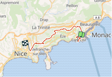
Randonnée Marche de 23 km à découvrir à Provence-Alpes-Côte d'Azur, Alpes-Maritimes, Cap-d'Ail. Cette randonnée est proposée par jouans.
Description
Nice Gare Riquier entrain jusqu'à Cap d'Ail La tête de chien La Turbie Fort Revere Col d'Eze Mont Fourche Plateau de la Justice Mont Leuze Le Vinaigrier Nice
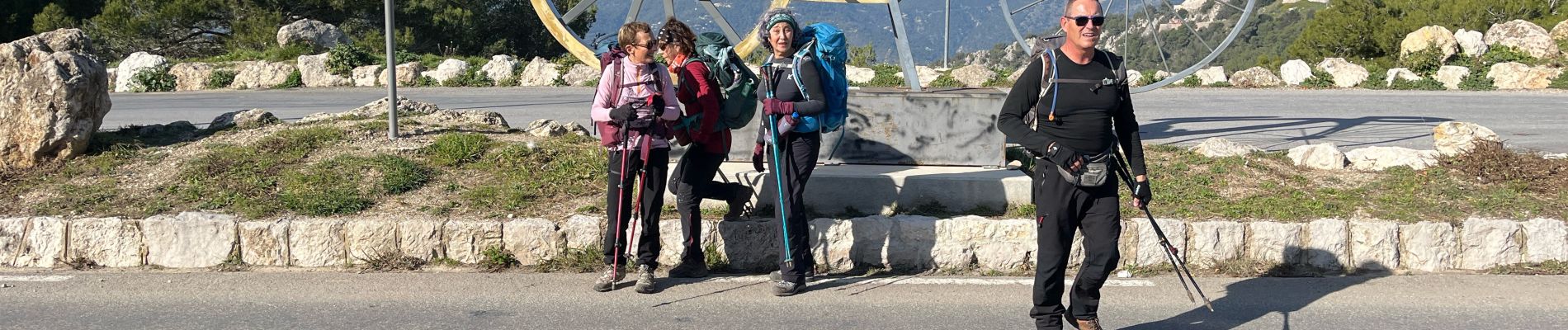
Sortie les exclus du 28/01/2024 à 5
Localisation
Pays :
France
Région :
Provence-Alpes-Côte d'Azur
Département/Province :
Alpes-Maritimes
Commune :
Cap-d'Ail
Localité :
Unknown
Départ:(Dec)
Départ:(UTM)
370654 ; 4842111 (32T) N.
Commentaires
Randonnées à proximité
![Randonnée A pied Èze - Circuit du mont Bastide - Photo](https://media.geolcdn.com/t/375/260/5ad7717b-c841-4266-a29b-c036d9f61957.jpeg&format=jpg&maxdim=2)
![A pied A pied](https://static1.geolcdn.com/sitytour/trail-icons/100.png)
Circuit du mont Bastide
A pied
Facile
Èze,
Provence-Alpes-Côte d'Azur,
Alpes-Maritimes,
France
![](/images/other/stat-length.png)
7 km | 14,7 km-effort
3h 20min
![](https://static1.geolcdn.com/siteimages/upload/files/16400158638029165_repeat_loop_refresh_sync_direction_icon.png)
Oui
![Randonnée Marche Èze - Mont Bastide, sentier de Nietzsche - Photo](https://media.geolcdn.com/t/375/260/ext.jpg?maxdim=2&url=https%3A%2F%2Fstatic1.geolcdn.com%2Fsiteimages%2Fupload%2Ffiles%2F1553511878bg_sport_marche.png)
![Marche Marche](https://static1.geolcdn.com/sitytour/trail-icons/101.png)
Mont Bastide, sentier de Nietzsche
Marche
Facile
(1)
Èze,
Provence-Alpes-Côte d'Azur,
Alpes-Maritimes,
France
![](/images/other/stat-length.png)
7,2 km | 15,1 km-effort
3h 15min
![](https://static1.geolcdn.com/siteimages/upload/files/16400158638029165_repeat_loop_refresh_sync_direction_icon.png)
Oui
![Randonnée Autre activité La Turbie - fort de la Revere - Photo](https://media.geolcdn.com/t/375/260/ext.jpg?maxdim=2&url=https%3A%2F%2Fstatic1.geolcdn.com%2Fsiteimages%2Fupload%2Ffiles%2F1545311037marcheuse_200dpi.jpg)
![Autre activité Autre activité](https://static1.geolcdn.com/sitytour/trail-icons/900.png)
fort de la Revere
Autre activité
Très facile
(1)
La Turbie,
Provence-Alpes-Côte d'Azur,
Alpes-Maritimes,
France
![](/images/other/stat-length.png)
8,4 km | 12 km-effort
1h 37min
![](https://static1.geolcdn.com/siteimages/upload/files/16400158638029165_repeat_loop_refresh_sync_direction_icon.png)
Oui
![Randonnée Marche Monaco - Monaco - 3.6km 95m 0h55 - 2015 06 16 - Photo](https://media.geolcdn.com/t/375/260/ext.jpg?maxdim=2&url=https%3A%2F%2Fservices.sitytrail.com%2FGeolivesWS%2FDownloadMedia.ashx%3FTrailID%3D435409%26Media%3Dfix__20150616153913.jpg)
![Marche Marche](https://static1.geolcdn.com/sitytour/trail-icons/101.png)
Monaco - 3.6km 95m 0h55 - 2015 06 16
Marche
Très facile
Monaco,
Inconnu,
Inconnu,
Monaco
![](/images/other/stat-length.png)
3,6 km | 4,9 km-effort
55min
![](https://static1.geolcdn.com/siteimages/upload/files/16400158638029165_repeat_loop_refresh_sync_direction_icon.png)
Oui
![Randonnée Marche Saint-Jean-Cap-Ferrat - Saint-Jean-Cap-Ferrat - Tour du Cap Ferrat - 7.1km 170m 1h40 - 2015 06 13 - Photo](https://media.geolcdn.com/t/375/260/ext.jpg?maxdim=2&url=https%3A%2F%2Fservices.sitytrail.com%2FGeolivesWS%2FDownloadMedia.ashx%3FTrailID%3D435405%26Media%3Dfix__20150613163217.jpg)
![Marche Marche](https://static1.geolcdn.com/sitytour/trail-icons/101.png)
Saint-Jean-Cap-Ferrat - Tour du Cap Ferrat - 7.1km 170m 1h40 - 2015 06 13
Marche
Facile
Saint-Jean-Cap-Ferrat,
Provence-Alpes-Côte d'Azur,
Alpes-Maritimes,
France
![](/images/other/stat-length.png)
7,1 km | 9,4 km-effort
1h 40min
![](https://static1.geolcdn.com/siteimages/upload/files/16400158638029165_repeat_loop_refresh_sync_direction_icon.png)
Oui
![Randonnée Marche Saint-Jean-Cap-Ferrat - w-frankrijk-tour-du-cap-ferrat - Photo](https://media.geolcdn.com/t/375/260/ext.jpg?maxdim=2&url=https%3A%2F%2Fstatic1.geolcdn.com%2Fsiteimages%2Fupload%2Ffiles%2F1553511878bg_sport_marche.png)
![Marche Marche](https://static1.geolcdn.com/sitytour/trail-icons/101.png)
w-frankrijk-tour-du-cap-ferrat
Marche
Très facile
(1)
Saint-Jean-Cap-Ferrat,
Provence-Alpes-Côte d'Azur,
Alpes-Maritimes,
France
![](/images/other/stat-length.png)
6,5 km | 8,6 km-effort
Inconnu
![](https://static1.geolcdn.com/siteimages/upload/files/16400158638029165_repeat_loop_refresh_sync_direction_icon.png)
Non
![Randonnée Marche Èze - eze 221213 - Photo](https://media.geolcdn.com/t/375/260/ext.jpg?maxdim=2&url=https%3A%2F%2Fstatic1.geolcdn.com%2Fsiteimages%2Fupload%2Ffiles%2F1553511878bg_sport_marche.png)
![Marche Marche](https://static1.geolcdn.com/sitytour/trail-icons/101.png)
eze 221213
Marche
Moyen
(1)
Èze,
Provence-Alpes-Côte d'Azur,
Alpes-Maritimes,
France
![](/images/other/stat-length.png)
9,9 km | 14,7 km-effort
2h 4min
![](https://static1.geolcdn.com/siteimages/upload/files/16400158638029165_repeat_loop_refresh_sync_direction_icon.png)
Oui
![Randonnée Marche Saint-Jean-Cap-Ferrat - Tour du Cap Ferrat - Photo](https://media.geolcdn.com/t/375/260/ext.jpg?maxdim=2&url=https%3A%2F%2Fservices.sitytrail.com%2FGeolivesWS%2FDownloadMedia.ashx%3FTrailID%3D105209%26Media%3D8849_1.jpg)
![Marche Marche](https://static1.geolcdn.com/sitytour/trail-icons/101.png)
Tour du Cap Ferrat
Marche
Moyen
(4)
Saint-Jean-Cap-Ferrat,
Provence-Alpes-Côte d'Azur,
Alpes-Maritimes,
France
![](/images/other/stat-length.png)
8,9 km | 11,2 km-effort
2h 0min
![](https://static1.geolcdn.com/siteimages/upload/files/16400158638029165_repeat_loop_refresh_sync_direction_icon.png)
Oui
![Randonnée Marche Saint-Jean-Cap-Ferrat - Le tour de la Presqu'ile de St Jean Cap Ferrat - Photo](https://media.geolcdn.com/t/375/260/701cf7de-4cfa-4004-9aea-c2fa39fa0153.jpeg&format=jpg&maxdim=2)
![Marche Marche](https://static1.geolcdn.com/sitytour/trail-icons/101.png)
Le tour de la Presqu'ile de St Jean Cap Ferrat
Marche
Facile
Saint-Jean-Cap-Ferrat,
Provence-Alpes-Côte d'Azur,
Alpes-Maritimes,
France
![](/images/other/stat-length.png)
10,9 km | 13,7 km-effort
3h 7min
![](https://static1.geolcdn.com/siteimages/upload/files/16400158638029165_repeat_loop_refresh_sync_direction_icon.png)
Oui