![](/images/other/stat-length.png)
![Randonnée Marche Nivelles - Nivelles: entre sa gare et le parc de la Dodaine. - Photo](https://media.geolcdn.com/t/1900/400/ext.pjpeg?maxdim=2&url=https%3A%2F%2Fstatic1.geolcdn.com%2Fsiteimages%2Fupload%2Ffiles%2F1553511878bg_sport_marche.png)
Nivelles: entre sa gare et le parc de la Dodaine.
Mady Lambert
Utilisateur
![Longueur](/images/other/stat-length.png)
Longueur
8,2 km
![Altitude max](https://static1.geolcdn.com/siteimages/upload/files/1508320355ic_sort_altitude_max_24dp.png)
Altitude max
146 m
![Dénivelé positif](https://static1.geolcdn.com/siteimages/upload/files/1508320355ic_sort_den_pos_24dp.png)
Dénivelé positif
104 m
![Km-Effort](/images/other/stat-length.png)
Km-Effort
9,6 km
![Altitude min](https://static1.geolcdn.com/siteimages/upload/files/1508320355ic_sort_altitude_min_24dp.png)
Altitude min
101 m
![Dénivelé négatif](https://static1.geolcdn.com/siteimages/upload/files/1508320355ic_sort_den_neg_24dp.png)
Dénivelé négatif
105 m
![Boucle](https://static1.geolcdn.com/siteimages/upload/files/16400158638029165_repeat_loop_refresh_sync_direction_icon.png)
Boucle
Oui
Date de création :
2024-01-27 12:15:15.377
Dernière modification :
2024-01-27 14:38:43.423
![Marche](https://static1.geolcdn.com/sitytour/trail-icons/101.png)
2h02
Difficulté : Moyen
![Scannez ce code QR pour ouvrir la randonnée dans l'application SityTrail](https://capi.geolives.com/qq0zvz2zws4bq2lad0pu/sitytour/trails/3929211/qr.png?size=200)
Application GPS de randonnée GRATUITE
À propos
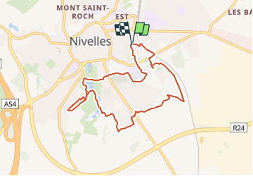
Randonnée Marche de 8,2 km à découvrir à Wallonie, Brabant wallon, Nivelles. Cette randonnée est proposée par Mady Lambert.
Description
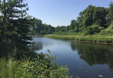
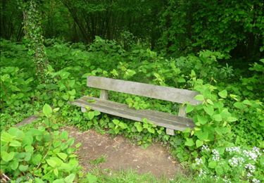
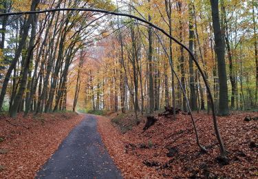
Sentiers, boisés ou non, traversées de prairies, passages entre les champs, rivières, quelques routes, traversée de la Dodaine.
Bonnes chaussures de marche, chien très souvent en liberté, encore plus si bon rappel.
Localisation
Pays :
Belgique
Région :
Wallonie
Département/Province :
Brabant wallon
Commune :
Nivelles
Localité :
Nivelles
Départ:(Dec)
Départ:(UTM)
594400 ; 5605878 (31U) N.
Commentaires
Randonnées à proximité
![Randonnée Marche Nivelles - RB-Bw-16_Monstreux_via-racc-1 - Photo](https://media.geolcdn.com/t/375/260/ext.jpg?maxdim=2&url=https%3A%2F%2Fservices.sitytrail.com%2FGeolivesWS%2FDownloadMedia.ashx%3FTrailID%3D354126%26Media%3Ddaedf7ee-f25e-4941-815b-dbbb8c629e47.jpg)
![Marche Marche](https://static1.geolcdn.com/sitytour/trail-icons/101.png)
RB-Bw-16_Monstreux_via-racc-1
Marche
Difficile
(11)
Nivelles,
Wallonie,
Brabant wallon,
Belgique
![](/images/other/stat-length.png)
12,8 km | 15 km-effort
3h 24min
![](https://static1.geolcdn.com/siteimages/upload/files/16400158638029165_repeat_loop_refresh_sync_direction_icon.png)
Oui
![Randonnée Marche Nivelles - RB-Bw-16_Monstreux_via-racc-2 - Photo](https://media.geolcdn.com/t/375/260/ext.jpg?maxdim=2&url=https%3A%2F%2Fservices.sitytrail.com%2FGeolivesWS%2FDownloadMedia.ashx%3FTrailID%3D221718%26Media%3Ddaedf7ee-f25e-4941-815b-dbbb8c629e47.jpg)
![Marche Marche](https://static1.geolcdn.com/sitytour/trail-icons/101.png)
RB-Bw-16_Monstreux_via-racc-2
Marche
Difficile
(9)
Nivelles,
Wallonie,
Brabant wallon,
Belgique
![](/images/other/stat-length.png)
16 km | 18,9 km-effort
4h 17min
![](https://static1.geolcdn.com/siteimages/upload/files/16400158638029165_repeat_loop_refresh_sync_direction_icon.png)
Oui
![Randonnée Marche Nivelles - RB-Bw-16_Monstreux - Photo](https://media.geolcdn.com/t/375/260/ext.jpg?maxdim=2&url=https%3A%2F%2Fservices.sitytrail.com%2FGeolivesWS%2FDownloadMedia.ashx%3FTrailID%3D179591%26Media%3D606a627b-9c11-4c95-a0ed-8415395e822e.jpg)
![Marche Marche](https://static1.geolcdn.com/sitytour/trail-icons/101.png)
RB-Bw-16_Monstreux
Marche
Très difficile
(11)
Nivelles,
Wallonie,
Brabant wallon,
Belgique
![](/images/other/stat-length.png)
20 km | 24 km-effort
5h 24min
![](https://static1.geolcdn.com/siteimages/upload/files/16400158638029165_repeat_loop_refresh_sync_direction_icon.png)
Oui
![Randonnée Marche Seneffe - De Arquennes à Monstreux par les vallées de la Thines et de la Samme - Photo](https://media.geolcdn.com/t/375/260/ext.jpg?maxdim=2&url=https%3A%2F%2Fservices.sitytrail.com%2FGeolivesWS%2FDownloadMedia.ashx%3FTrailID%3D127787%26Media%3D79b12576-f9f5-4657-a448-2793aa9c7eb2.JPG)
![Marche Marche](https://static1.geolcdn.com/sitytour/trail-icons/101.png)
De Arquennes à Monstreux par les vallées de la Thines et de la Samme
Marche
Facile
(6)
Seneffe,
Wallonie,
Hainaut,
Belgique
![](/images/other/stat-length.png)
13,7 km | 15,4 km-effort
3h 30min
![](https://static1.geolcdn.com/siteimages/upload/files/16400158638029165_repeat_loop_refresh_sync_direction_icon.png)
Oui
![Randonnée Marche Nivelles - Rando Bornival - Photo](https://media.geolcdn.com/t/375/260/ext.jpg?maxdim=2&url=https%3A%2F%2Fstatic1.geolcdn.com%2Fsiteimages%2Fupload%2Ffiles%2F1553511878bg_sport_marche.png)
![Marche Marche](https://static1.geolcdn.com/sitytour/trail-icons/101.png)
Rando Bornival
Marche
Facile
(5)
Nivelles,
Wallonie,
Brabant wallon,
Belgique
![](/images/other/stat-length.png)
13,2 km | 15,9 km-effort
3h 27min
![](https://static1.geolcdn.com/siteimages/upload/files/16400158638029165_repeat_loop_refresh_sync_direction_icon.png)
Oui
![Marche Marche](https://static1.geolcdn.com/sitytour/trail-icons/101.png)
BE-Bornival - Bois d'En-Bas - Ecluse 24 - Ancien canal
Marche
Moyen
(3)
Nivelles,
Wallonie,
Brabant wallon,
Belgique
![](/images/other/stat-length.png)
6,3 km | 7,5 km-effort
1h 41min
![](https://static1.geolcdn.com/siteimages/upload/files/16400158638029165_repeat_loop_refresh_sync_direction_icon.png)
Oui
![Randonnée Marche Seneffe - BE-Seneffe - Arquennes - Hameau Les Bois et l'ancien canal - Photo](https://media.geolcdn.com/t/375/260/eb61f70b-cfa0-40f0-88f8-9754f883475d.jpg&format=jpg&maxdim=2)
![Marche Marche](https://static1.geolcdn.com/sitytour/trail-icons/101.png)
BE-Seneffe - Arquennes - Hameau Les Bois et l'ancien canal
Marche
Moyen
(4)
Seneffe,
Wallonie,
Hainaut,
Belgique
![](/images/other/stat-length.png)
8,4 km | 9,5 km-effort
1h 52min
![](https://static1.geolcdn.com/siteimages/upload/files/16400158638029165_repeat_loop_refresh_sync_direction_icon.png)
Oui
![Randonnée Marche nordique Seneffe - De Arquennes à Nivelles par le RAVEl et l'ancien canal - Photo](https://media.geolcdn.com/t/375/260/ext.jpg?maxdim=2&url=https%3A%2F%2Fservices.sitytrail.com%2FGeolivesWS%2FDownloadMedia.ashx%3FTrailID%3D268082%26Media%3Dea1a030b-8c73-4fe5-a6f0-117246010a21.jpg)
![Marche nordique Marche nordique](https://static1.geolcdn.com/sitytour/trail-icons/102.png)
De Arquennes à Nivelles par le RAVEl et l'ancien canal
Marche nordique
Moyen
(2)
Seneffe,
Wallonie,
Hainaut,
Belgique
![](/images/other/stat-length.png)
9,8 km | 11 km-effort
2h 16min
![](https://static1.geolcdn.com/siteimages/upload/files/16400158638029165_repeat_loop_refresh_sync_direction_icon.png)
Oui
![Randonnée Marche Nivelles - Bornival 1119 - Photo](https://media.geolcdn.com/t/375/260/786746a7-db37-4cff-abae-9c5a1c7421c4.jpg&format=jpg&maxdim=2)
![Marche Marche](https://static1.geolcdn.com/sitytour/trail-icons/101.png)
Bornival 1119
Marche
Facile
(2)
Nivelles,
Wallonie,
Brabant wallon,
Belgique
![](/images/other/stat-length.png)
9 km | 10,5 km-effort
2h 7min
![](https://static1.geolcdn.com/siteimages/upload/files/16400158638029165_repeat_loop_refresh_sync_direction_icon.png)
Oui