![](/images/other/stat-length.png)
![Randonnée A pied Flayosc - L Héraude forêt de Flayosc G4 - Photo](https://media.geolcdn.com/t/1900/400/ext.pjpeg?maxdim=2&url=https%3A%2F%2Fstatic1.geolcdn.com%2Fsiteimages%2Fupload%2Ffiles%2F1545311037marcheuse_200dpi.jpg)
L Héraude forêt de Flayosc G4
felix83
Utilisateur
![Longueur](/images/other/stat-length.png)
Longueur
6,9 km
![Altitude max](https://static1.geolcdn.com/siteimages/upload/files/1508320355ic_sort_altitude_max_24dp.png)
Altitude max
388 m
![Dénivelé positif](https://static1.geolcdn.com/siteimages/upload/files/1508320355ic_sort_den_pos_24dp.png)
Dénivelé positif
77 m
![Km-Effort](/images/other/stat-length.png)
Km-Effort
8 km
![Altitude min](https://static1.geolcdn.com/siteimages/upload/files/1508320355ic_sort_altitude_min_24dp.png)
Altitude min
334 m
![Dénivelé négatif](https://static1.geolcdn.com/siteimages/upload/files/1508320355ic_sort_den_neg_24dp.png)
Dénivelé négatif
77 m
![Boucle](https://static1.geolcdn.com/siteimages/upload/files/16400158638029165_repeat_loop_refresh_sync_direction_icon.png)
Boucle
Oui
Date de création :
2024-01-24 14:46:36.542
Dernière modification :
2024-01-24 14:57:11.554
![A pied](https://static1.geolcdn.com/sitytour/trail-icons/100.png)
1h48
Difficulté : Facile
![Scannez ce code QR pour ouvrir la randonnée dans l'application SityTrail](https://capi.geolives.com/qq0zvz2zws4bq2lad0pu/sitytour/trails/3926180/qr.png?size=200)
Application GPS de randonnée GRATUITE
À propos
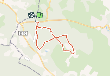
Randonnée A pied de 6,9 km à découvrir à Provence-Alpes-Côte d'Azur, Var, Flayosc. Cette randonnée est proposée par felix83.
Description
Petite randonnée sans difficulté dans la forêt de Flayosc (83).
Staionnement des voitures possible sur le bord de la départementale D557 (Route de Salernes)
Localisation
Pays :
France
Région :
Provence-Alpes-Côte d'Azur
Département/Province :
Var
Commune :
Flayosc
Localité :
Unknown
Départ:(Dec)
Départ:(UTM)
283515 ; 4824813 (32T) N.
Commentaires
Randonnées à proximité
![Randonnée Marche Villecroze - 2023-10-31 Villecroz - Tourtour et tourisme - Photo](https://media.geolcdn.com/t/375/260/f84ff7d5-400b-494e-8808-c59b480ad1f2.jpg&format=jpg&maxdim=2)
![Marche Marche](https://static1.geolcdn.com/sitytour/trail-icons/101.png)
2023-10-31 Villecroz - Tourtour et tourisme
Marche
Moyen
Villecroze,
Provence-Alpes-Côte d'Azur,
Var,
France
![](/images/other/stat-length.png)
17,6 km | 24 km-effort
5h 28min
![](https://static1.geolcdn.com/siteimages/upload/files/16400158638029165_repeat_loop_refresh_sync_direction_icon.png)
Oui
![Randonnée Marche Villecroze - Villecroze de Chapelles en Grottes - Photo](https://media.geolcdn.com/t/375/260/b4f00218-714a-4329-ac66-fe1861cf789d.jpg&format=jpg&maxdim=2)
![Marche Marche](https://static1.geolcdn.com/sitytour/trail-icons/101.png)
Villecroze de Chapelles en Grottes
Marche
Très difficile
Villecroze,
Provence-Alpes-Côte d'Azur,
Var,
France
![](/images/other/stat-length.png)
19,9 km | 28 km-effort
5h 49min
![](https://static1.geolcdn.com/siteimages/upload/files/16400158638029165_repeat_loop_refresh_sync_direction_icon.png)
Oui
![Randonnée Marche Tourtour - Tourtour - Les Moulières - Photo](https://media.geolcdn.com/t/375/260/ext.jpg?maxdim=2&url=https%3A%2F%2Fstatic1.geolcdn.com%2Fsiteimages%2Fupload%2Ffiles%2F1553511878bg_sport_marche.png)
![Marche Marche](https://static1.geolcdn.com/sitytour/trail-icons/101.png)
Tourtour - Les Moulières
Marche
Moyen
(1)
Tourtour,
Provence-Alpes-Côte d'Azur,
Var,
France
![](/images/other/stat-length.png)
13,1 km | 15,6 km-effort
5h 0min
![](https://static1.geolcdn.com/siteimages/upload/files/16400158638029165_repeat_loop_refresh_sync_direction_icon.png)
Oui
![Randonnée Autre activité Villecroze - fox - Photo](https://media.geolcdn.com/t/375/260/ext.jpg?maxdim=2&url=https%3A%2F%2Fstatic1.geolcdn.com%2Fsiteimages%2Fupload%2Ffiles%2F1545311037marcheuse_200dpi.jpg)
![Autre activité Autre activité](https://static1.geolcdn.com/sitytour/trail-icons/900.png)
fox
Autre activité
Moyen
(1)
Villecroze,
Provence-Alpes-Côte d'Azur,
Var,
France
![](/images/other/stat-length.png)
42 km | 52 km-effort
2h 24min
![](https://static1.geolcdn.com/siteimages/upload/files/16400158638029165_repeat_loop_refresh_sync_direction_icon.png)
Oui
![Randonnée V.T.T. Villecroze - st bart - Photo](https://media.geolcdn.com/t/375/260/ext.jpg?maxdim=2&url=https%3A%2F%2Fstatic1.geolcdn.com%2Fsiteimages%2Fupload%2Ffiles%2F1524743154velo.jpg)
![V.T.T. V.T.T.](https://static1.geolcdn.com/sitytour/trail-icons/202.png)
st bart
V.T.T.
Difficile
(1)
Villecroze,
Provence-Alpes-Côte d'Azur,
Var,
France
![](/images/other/stat-length.png)
33 km | 42 km-effort
2h 20min
![](https://static1.geolcdn.com/siteimages/upload/files/16400158638029165_repeat_loop_refresh_sync_direction_icon.png)
Oui
![Randonnée V.T.T. Villecroze - giant vs haibike - Photo](https://media.geolcdn.com/t/375/260/ext.jpg?maxdim=2&url=https%3A%2F%2Fstatic1.geolcdn.com%2Fsiteimages%2Fupload%2Ffiles%2F1524743154velo.jpg)
![V.T.T. V.T.T.](https://static1.geolcdn.com/sitytour/trail-icons/202.png)
giant vs haibike
V.T.T.
Moyen
(1)
Villecroze,
Provence-Alpes-Côte d'Azur,
Var,
France
![](/images/other/stat-length.png)
29 km | 36 km-effort
1h 49min
![](https://static1.geolcdn.com/siteimages/upload/files/16400158638029165_repeat_loop_refresh_sync_direction_icon.png)
Oui
![Randonnée Marche Villecroze - VILLECROZE TOURTOUR N - Photo](https://media.geolcdn.com/t/375/260/599e5e7e-da69-49e5-8690-f7d254b7e4d2.jpg&format=jpg&maxdim=2)
![Marche Marche](https://static1.geolcdn.com/sitytour/trail-icons/101.png)
VILLECROZE TOURTOUR N
Marche
Très difficile
Villecroze,
Provence-Alpes-Côte d'Azur,
Var,
France
![](/images/other/stat-length.png)
15,1 km | 21 km-effort
4h 33min
![](https://static1.geolcdn.com/siteimages/upload/files/16400158638029165_repeat_loop_refresh_sync_direction_icon.png)
Oui
![Randonnée Marche Villecroze - Villecroze- Domaine Saint Jean - Photo](https://media.geolcdn.com/t/375/260/1159e4c7-252a-4789-9dc1-6697f859dafa.jpg&format=jpg&maxdim=2)
![Marche Marche](https://static1.geolcdn.com/sitytour/trail-icons/101.png)
Villecroze- Domaine Saint Jean
Marche
Facile
Villecroze,
Provence-Alpes-Côte d'Azur,
Var,
France
![](/images/other/stat-length.png)
4,3 km | 5,4 km-effort
1h 16min
![](https://static1.geolcdn.com/siteimages/upload/files/16400158638029165_repeat_loop_refresh_sync_direction_icon.png)
Non
![Randonnée sport Saint-Antonin-du-Var - 2024-02-05_17h29m21_st antonin demain - Photo](https://media.geolcdn.com/t/375/260/ext.jpg?maxdim=2&url=https%3A%2F%2Fsecurestorage.geolives.com%2Fsitytour%2Ftrail-bg%2Fdefault.jpg)
2024-02-05_17h29m21_st antonin demain
sport
Très facile
(1)
Saint-Antonin-du-Var,
Provence-Alpes-Côte d'Azur,
Var,
France
![](/images/other/stat-length.png)
27 km | 35 km-effort
Inconnu
![](https://static1.geolcdn.com/siteimages/upload/files/16400158638029165_repeat_loop_refresh_sync_direction_icon.png)
Oui