![](/images/other/stat-length.png)
![Randonnée Marche Saint-Cloud - Berges_de_Seine_et_Bois_de_Boulogne_ - Photo](https://media.geolcdn.com/t/1900/400/ext.pjpeg?maxdim=2&url=https%3A%2F%2Fstatic1.geolcdn.com%2Fsiteimages%2Fupload%2Ffiles%2F1553511878bg_sport_marche.png)
Berges_de_Seine_et_Bois_de_Boulogne_
jpcccb
Utilisateur
![Longueur](/images/other/stat-length.png)
Longueur
12,8 km
![Altitude max](https://static1.geolcdn.com/siteimages/upload/files/1508320355ic_sort_altitude_max_24dp.png)
Altitude max
93 m
![Dénivelé positif](https://static1.geolcdn.com/siteimages/upload/files/1508320355ic_sort_den_pos_24dp.png)
Dénivelé positif
169 m
![Km-Effort](/images/other/stat-length.png)
Km-Effort
15,2 km
![Altitude min](https://static1.geolcdn.com/siteimages/upload/files/1508320355ic_sort_altitude_min_24dp.png)
Altitude min
17 m
![Dénivelé négatif](https://static1.geolcdn.com/siteimages/upload/files/1508320355ic_sort_den_neg_24dp.png)
Dénivelé négatif
215 m
![Boucle](https://static1.geolcdn.com/siteimages/upload/files/16400158638029165_repeat_loop_refresh_sync_direction_icon.png)
Boucle
Non
Date de création :
2024-01-20 12:03:51.743
Dernière modification :
2024-03-04 17:37:43.656
![Marche](https://static1.geolcdn.com/sitytour/trail-icons/101.png)
3h27
Difficulté : Difficile
![Scannez ce code QR pour ouvrir la randonnée dans l'application SityTrail](https://capi.geolives.com/qq0zvz2zws4bq2lad0pu/sitytour/trails/3921706/qr.png?size=200)
Application GPS de randonnée GRATUITE
À propos
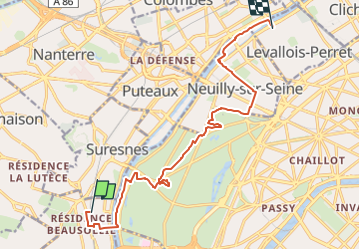
Randonnée Marche de 12,8 km à découvrir à Île-de-France, Hauts-de-Seine, Saint-Cloud. Cette randonnée est proposée par jpcccb.
Description
Découvrez l'île de la Grande-Jatte, le bois de Boulogne et les berges de la Seine. Randonnée Labellisée TopoGuide Hauts-de-Seine balade No 6
Localisation
Pays :
France
Région :
Île-de-France
Département/Province :
Hauts-de-Seine
Commune :
Saint-Cloud
Localité :
Unknown
Départ:(Dec)
Départ:(UTM)
442545 ; 5411795 (31U) N.
Commentaires
Randonnées à proximité
![Randonnée Marche Chaville - GRP CV-IDF 20R Chaville à Vaucresson - Photo](https://media.geolcdn.com/t/375/260/ext.jpg?maxdim=2&url=https%3A%2F%2Fmedia.geolcdn.com%2Ff%2Fee9d0d3a-696b-449f-af8b-f1928f5c8b40.jpg)
![Marche Marche](https://static1.geolcdn.com/sitytour/trail-icons/101.png)
GRP CV-IDF 20R Chaville à Vaucresson
Marche
Moyen
(1)
Chaville,
Île-de-France,
Hauts-de-Seine,
France
![](/images/other/stat-length.png)
8,2 km | 11,1 km-effort
2h 30min
![](https://static1.geolcdn.com/siteimages/upload/files/16400158638029165_repeat_loop_refresh_sync_direction_icon.png)
Non
![Randonnée Marche Paris - DP75-11 De Boulainvilliers à pont du Garigliano - Photo](https://media.geolcdn.com/t/375/260/ext.jpg?maxdim=2&url=https%3A%2F%2Fmedia.geolcdn.com%2Ff%2F65f6b9b8-257b-4cb3-ae12-0b82159348dc.jpg)
![Marche Marche](https://static1.geolcdn.com/sitytour/trail-icons/101.png)
DP75-11 De Boulainvilliers à pont du Garigliano
Marche
Facile
(1)
Paris,
Île-de-France,
Paris,
France
![](/images/other/stat-length.png)
4,7 km | 5,4 km-effort
1h 13min
![](https://static1.geolcdn.com/siteimages/upload/files/16400158638029165_repeat_loop_refresh_sync_direction_icon.png)
Non
![Randonnée Marche Paris - DP75-19 de Porte-Maillot à Europe - Photo](https://media.geolcdn.com/t/375/260/ext.jpg?maxdim=2&url=https%3A%2F%2Fmedia.geolcdn.com%2Ff%2F159be267-b3d1-40ca-b7c5-4227580bd0ba.jpg)
![Marche Marche](https://static1.geolcdn.com/sitytour/trail-icons/101.png)
DP75-19 de Porte-Maillot à Europe
Marche
Facile
(1)
Paris,
Île-de-France,
Paris,
France
![](/images/other/stat-length.png)
4,2 km | 4,8 km-effort
1h 5min
![](https://static1.geolcdn.com/siteimages/upload/files/16400158638029165_repeat_loop_refresh_sync_direction_icon.png)
Non
![Randonnée Vélo Paris - Paris au bord de Seine - Photo](https://media.geolcdn.com/t/375/260/ext.jpg?maxdim=2&url=https%3A%2F%2Fservices.sitytrail.com%2FGeolivesWS%2FDownloadMedia.ashx%3FTrailID%3D137119%26Media%3D20120703185331.jpg)
![Vélo Vélo](https://static1.geolcdn.com/sitytour/trail-icons/200.png)
Paris au bord de Seine
Vélo
Très facile
(1)
Paris,
Île-de-France,
Paris,
France
![](/images/other/stat-length.png)
11,4 km | 14,2 km-effort
46min
![](https://static1.geolcdn.com/siteimages/upload/files/16400158638029165_repeat_loop_refresh_sync_direction_icon.png)
Non
![Randonnée Marche Paris - 75-04-Paris les Ponts 13km-493-55- - Photo](https://media.geolcdn.com/t/375/260/ext.jpg?maxdim=2&url=https%3A%2F%2Fmedia.geolcdn.com%2Ff%2Fffa79fa9-c1ae-4345-951e-9e30af6e17a7.jpg)
![Marche Marche](https://static1.geolcdn.com/sitytour/trail-icons/101.png)
75-04-Paris les Ponts 13km-493-55-
Marche
Facile
(1)
Paris,
Île-de-France,
Paris,
France
![](/images/other/stat-length.png)
13,1 km | 16,3 km-effort
3h 22min
![](https://static1.geolcdn.com/siteimages/upload/files/16400158638029165_repeat_loop_refresh_sync_direction_icon.png)
Non
![Randonnée Marche Boulogne-Billancourt - Parc de St Cloud et forêt de Fausses Reposes - Photo](https://media.geolcdn.com/t/375/260/ext.jpg?maxdim=2&url=https%3A%2F%2Fservices.sitytrail.com%2FGeolivesWS%2FDownloadMedia.ashx%3FTrailID%3D106613%26Media%3D11213_2.jpg)
![Marche Marche](https://static1.geolcdn.com/sitytour/trail-icons/101.png)
Parc de St Cloud et forêt de Fausses Reposes
Marche
Moyen
(1)
Boulogne-Billancourt,
Île-de-France,
Hauts-de-Seine,
France
![](/images/other/stat-length.png)
18,2 km | 23 km-effort
4h 30min
![](https://static1.geolcdn.com/siteimages/upload/files/16400158638029165_repeat_loop_refresh_sync_direction_icon.png)
Non
![Randonnée Marche Paris - 019 - Paris - D'Auteuil au Grand Palais - Photo](https://media.geolcdn.com/t/375/260/ext.jpg?maxdim=2&url=https%3A%2F%2Fmedia.geolcdn.com%2Ff%2F22ec3bf9-7d39-4567-8fa4-c069569094a4.jfif)
![Marche Marche](https://static1.geolcdn.com/sitytour/trail-icons/101.png)
019 - Paris - D'Auteuil au Grand Palais
Marche
Difficile
(1)
Paris,
Île-de-France,
Paris,
France
![](/images/other/stat-length.png)
11,1 km | 13,8 km-effort
3h 8min
![](https://static1.geolcdn.com/siteimages/upload/files/16400158638029165_repeat_loop_refresh_sync_direction_icon.png)
Non
![Randonnée Vélo Chaville - chaville - maison lafitte - Photo](https://media.geolcdn.com/t/375/260/ext.jpg?maxdim=2&url=https%3A%2F%2Fstatic1.geolcdn.com%2Fsiteimages%2Fupload%2Ffiles%2F1524743154velo.jpg)
![Vélo Vélo](https://static1.geolcdn.com/sitytour/trail-icons/200.png)
chaville - maison lafitte
Vélo
Moyen
(1)
Chaville,
Île-de-France,
Hauts-de-Seine,
France
![](/images/other/stat-length.png)
44 km | 50 km-effort
3h 27min
![](https://static1.geolcdn.com/siteimages/upload/files/16400158638029165_repeat_loop_refresh_sync_direction_icon.png)
Non
![Randonnée Marche Paris - GR1 Tour de Paris. De la Porte Maillot (Paris) à Nesles-la-Vallée (Val-d'Oise) - Photo](https://media.geolcdn.com/t/375/260/ext.jpg?maxdim=2&url=https%3A%2F%2Fstatic1.geolcdn.com%2Fsiteimages%2Fupload%2Ffiles%2F1553511878bg_sport_marche.png)
![Marche Marche](https://static1.geolcdn.com/sitytour/trail-icons/101.png)
GR1 Tour de Paris. De la Porte Maillot (Paris) à Nesles-la-Vallée (Val-d'Oise)
Marche
Très facile
(1)
Paris,
Île-de-France,
Paris,
France
![](/images/other/stat-length.png)
237 km | 288 km-effort
Inconnu
![](https://static1.geolcdn.com/siteimages/upload/files/16400158638029165_repeat_loop_refresh_sync_direction_icon.png)
Non