Randonnée Marche Saint-Christophe-du-Foc - St christophecdu foc - Photo
 clrunavot
clrunavot

Utilisateur

© OpenStreetMap contributors
Longueur
Longueur
11,1 km
Altitude max
Altitude max
96 m
Dénivelé positif
Dénivelé positif
126 m
Km-Effort
Km-Effort  
12,7 km
Altitude min
Altitude min
52 m
Dénivelé négatif
Dénivelé négatif
125 m
Boucle
Boucle
Oui
Date de création :
2024-01-19 13:05:29.549
Dernière modification :
2024-01-19 16:14:25.032

(0 Avis)

Marche
Marche
3h08
Difficulté : Difficile

Scannez ce code QR pour ouvrir la randonnée dans l'application SityTrail

Application GPS de randonnée GRATUITE

Logo SityTrail SityTrail

IGN / Instituts géographiques

Télécharger SityTrail sur l'App Store Télécharger SityTrail sur Google Play

Logo SityTrail SityTrail World

Le monde est à vous

Télécharger SityTrail sur l'App Store Télécharger SityTrail sur Google Play Télécharger SityTrail sur Huawei AppGallery

À propos

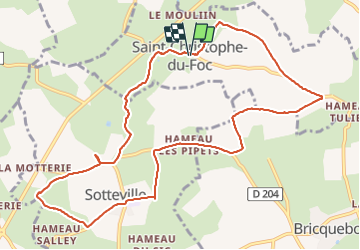
Randonnée Marche de 11,1 km à découvrir à Normandie, Manche, Saint-Christophe-du-Foc. Cette randonnée est proposée par clrunavot.
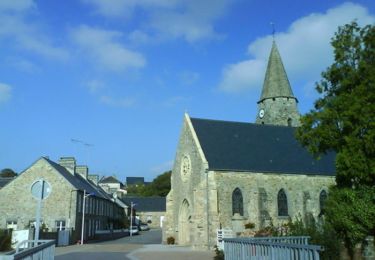
Description

église

Profil altimétrique

Localisation

Pays :
France
Région :
Normandie
Département/Province :
Manche
Commune :
Saint-Christophe-du-Foc
Localité :
Unknown
Départ:(UTM)
590972 ; 5489935 (30U) N.

Randonnées à proximité

Randonnée Marche Les Pieux - Entre terre et mer - Les Pieux - Photo
Marche
tracegps

Marche

Moyen
(2)
Les Pieux, Normandie, Manche, France
23 km | 28 km-effort
6h 0min
Oui
Randonnée V.T.T. Benoîtville - De Benoîtville à Saint Christophe du Foc - Circuit n° 12 - Photo
V.T.T.
tracegps

V.T.T.

Moyen
(1)
Benoîtville, Normandie, Manche, France
21 km | 24 km-effort
1h 45min
Oui
Randonnée V.T.T. La Hague - Le Chaudron de Thor 2013 - 60 km - Vasteville - Photo
V.T.T.
tracegps

V.T.T.

Difficile
La Hague, Normandie, Manche, France
57 km | 70 km-effort
3h 0min
Oui
Randonnée Course à pied Les Pieux - Entre terre et mer - Les Pieux - Photo
Course à pied
tracegps

Course à pied

Difficile
Les Pieux, Normandie, Manche, France
23 km | 28 km-effort
3h 0min
Oui
Randonnée V.T.T. La Hague - Les fils d'Artaud - Vasteville - Photo
V.T.T.
tracegps

V.T.T.

Moyen
La Hague, Normandie, Manche, France
34 km | 40 km-effort
2h 0min
Oui
Randonnée V.T.T. La Hague - Guillaume spot 2012 - Vasteville - Photo
V.T.T.
tracegps

V.T.T.

Facile
La Hague, Normandie, Manche, France
28 km | 33 km-effort
1h 30min
Oui
Randonnée V.T.T. La Hague - Le Tour de Grégoire - Vasteville - Photo
V.T.T.
tracegps

V.T.T.

Moyen
La Hague, Normandie, Manche, France
23 km | 28 km-effort
2h 0min
Oui
Randonnée V.T.T. Bricquebosq - People are strange track - MTB from Bricquebosc - Photo
V.T.T.
tracegps

V.T.T.

Moyen
Bricquebosq, Normandie, Manche, France
45 km | 54 km-effort
3h 0min
Oui
Randonnée V.T.T. La Hague - Chaudron de Thor 2011 - 60 kms - Vasteville - Photo
V.T.T.
tracegps

V.T.T.

Difficile
La Hague, Normandie, Manche, France
64 km | 76 km-effort
3h 30min
Oui


Fermer
Mes abonnements