Randonnée Marche Choranche - Etape3-GR9-Autrans-Leoncel - Photo

Etape3-GR9-Autrans-Leoncel

 Jean Pierre Parent
Jean Pierre Parent

Utilisateur

© OpenStreetMap contributors
Longueur
Longueur
10,4 km
Altitude max
Altitude max
424 m
Dénivelé positif
Dénivelé positif
329 m
Km-Effort
Km-Effort  
14,6 km
Altitude min
Altitude min
199 m
Dénivelé négatif
Dénivelé négatif
289 m
Boucle
Boucle
Non
Date de création :
2024-01-14 14:48:38.161
Dernière modification :
2024-08-16 15:17:42.761

(0 Avis)

Marche
Marche
3h19
Difficulté : Difficile

Scannez ce code QR pour ouvrir la randonnée dans l'application SityTrail

Application GPS de randonnée GRATUITE

Logo SityTrail SityTrail

IGN / Instituts géographiques

Télécharger SityTrail sur l'App Store Télécharger SityTrail sur Google Play

Logo SityTrail SityTrail World

Le monde est à vous

Télécharger SityTrail sur l'App Store Télécharger SityTrail sur Google Play Télécharger SityTrail sur Huawei AppGallery

À propos

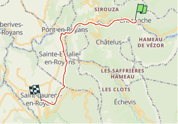
Randonnée Marche de 10,4 km à découvrir à Auvergne-Rhône-Alpes, Isère, Choranche. Cette randonnée est proposée par Jean Pierre Parent.

Description

départ Choranche
arrivée Saint Laurent en Royan Gîte le séchoir 25 impasse du séchoir

Profil altimétrique

Localisation

Pays :
France
Région :
Auvergne-Rhône-Alpes
Département/Province :
Isère
Commune :
Choranche
Localité :
Unknown
Départ:(UTM)
688285 ; 4993164 (31T) N.

Randonnées à proximité

Randonnée Marche Châtelus - 38 bournillon porte du diable charmatte - Photo
Marche
GUIDE
randodyssée

Marche

Difficile
(1)
Châtelus, Auvergne-Rhône-Alpes, Isère, France
16,5 km | 34 km-effort
8h 7min
Oui
Randonnée Marche Châtelus - Boucle Pas de l'Allier - Pas des Voutes - Photo
Marche
tracegps

Marche

Moyen
(1)
Châtelus, Auvergne-Rhône-Alpes, Isère, France
10,1 km | 22 km-effort
4h 30min
Oui
Randonnée Marche Sainte-Eulalie-en-Royans - 26 ste eulalie - Photo
Marche
GUIDE
randodyssée

Marche

Moyen
Sainte-Eulalie-en-Royans, Auvergne-Rhône-Alpes, Drôme, France
14,8 km | 27 km-effort
6h 43min
Non
Randonnée Marche Châtelus - 38 pabro charmatte - Photo
Marche
GUIDE
randodyssée

Marche

Difficile
Châtelus, Auvergne-Rhône-Alpes, Isère, France
11,4 km | 29 km-effort
7h 43min
Oui
Randonnée Marche Pont-en-Royans - 38 pont en Royans choranche presles - Photo
Marche
GUIDE
randodyssée

Marche

Difficile
Pont-en-Royans, Auvergne-Rhône-Alpes, Isère, France
15,4 km | 30 km-effort
6h 52min
Oui
Randonnée Marche Pont-en-Royans - 38 pont en Royans st andre - Photo
Marche
GUIDE
randodyssée

Marche

Facile
Pont-en-Royans, Auvergne-Rhône-Alpes, Isère, France
14,1 km | 19,3 km-effort
3h 33min
Oui
Randonnée Marche Pont-en-Royans - 38 pont en Royans serre cocu - Photo
Marche
GUIDE
randodyssée

Marche

Moyen
Pont-en-Royans, Auvergne-Rhône-Alpes, Isère, France
16 km | 29 km-effort
7h 44min
Oui
Randonnée Marche Châtelus - la grande cournouse - Photo
Marche
GUIDE
nadd73

Marche

Difficile
Châtelus, Auvergne-Rhône-Alpes, Isère, France
10,5 km | 26 km-effort
6h 34min
Oui
Randonnée Marche Châtelus - la grotte des Gaulois, le pas de l' Echarasson, porte du diable, pas de charmate - Photo
Marche
GUIDE
nadd73

Marche

Difficile
Châtelus, Auvergne-Rhône-Alpes, Isère, France
18,3 km | 37 km-effort
8h 23min
Oui


Fermer
Mes abonnements