![](/images/other/stat-length.png)
![Randonnée Marche Dammartin-sur-Tigeaux - RS 21 Dammartin sur Tigeaux 20km 450m - Photo](https://media.geolcdn.com/t/1900/400/ext.pjpeg?maxdim=2&url=https%3A%2F%2Fstatic1.geolcdn.com%2Fsiteimages%2Fupload%2Ffiles%2F1553511878bg_sport_marche.png)
RS 21 Dammartin sur Tigeaux 20km 450m
Les 1000 pattes
Club randonnées SERVON
![Longueur](/images/other/stat-length.png)
Longueur
20 km
![Altitude max](https://static1.geolcdn.com/siteimages/upload/files/1508320355ic_sort_altitude_max_24dp.png)
Altitude max
133 m
![Dénivelé positif](https://static1.geolcdn.com/siteimages/upload/files/1508320355ic_sort_den_pos_24dp.png)
Dénivelé positif
446 m
![Km-Effort](/images/other/stat-length.png)
Km-Effort
26 km
![Altitude min](https://static1.geolcdn.com/siteimages/upload/files/1508320355ic_sort_altitude_min_24dp.png)
Altitude min
51 m
![Dénivelé négatif](https://static1.geolcdn.com/siteimages/upload/files/1508320355ic_sort_den_neg_24dp.png)
Dénivelé négatif
445 m
![Boucle](https://static1.geolcdn.com/siteimages/upload/files/16400158638029165_repeat_loop_refresh_sync_direction_icon.png)
Boucle
Oui
Date de création :
2024-01-09 15:57:21.919
Dernière modification :
2024-06-25 16:38:59.488
![Marche](https://static1.geolcdn.com/sitytour/trail-icons/101.png)
5h56
Difficulté : Très difficile
![Scannez ce code QR pour ouvrir la randonnée dans l'application SityTrail](https://capi.geolives.com/qq0zvz2zws4bq2lad0pu/sitytour/trails/3911908/qr.png?size=200)
Application GPS de randonnée GRATUITE
À propos
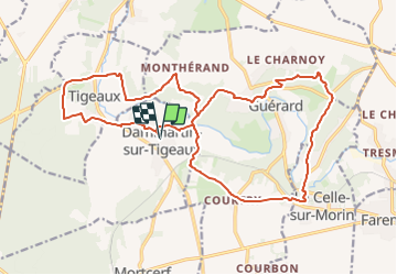
Randonnée Marche de 20 km à découvrir à Île-de-France, Seine-et-Marne, Dammartin-sur-Tigeaux. Cette randonnée est proposée par Les 1000 pattes.
Description
Parking : 7 Avenue de la Gare, 77163 Dammartin-sur-Tigeaux
Trajet : 40mn 32km
Localisation
Pays :
France
Région :
Île-de-France
Département/Province :
Seine-et-Marne
Commune :
Dammartin-sur-Tigeaux
Localité :
Unknown
Départ:(Dec)
Départ:(UTM)
494290 ; 5407118 (31U) N.
Commentaires
Randonnées à proximité
![Randonnée V.T.T. Mortcerf - Espace VTT FFC - Les Coteaux du Morin et de l'Aubetin - Circuit n° 12 - Mortcerf - Photo](https://media.geolcdn.com/t/375/260/ext.jpg?maxdim=2&url=https%3A%2F%2Fservices.sitytrail.com%2FGeolivesWS%2FDownloadMedia.ashx%3FTrailID%3D104876%26Media%3D8399_1.jpg)
![V.T.T. V.T.T.](https://static1.geolcdn.com/sitytour/trail-icons/202.png)
Espace VTT FFC - Les Coteaux du Morin et de l'Aubetin - Circuit n° 12 - Mortcerf
V.T.T.
Moyen
(1)
Mortcerf,
Île-de-France,
Seine-et-Marne,
France
![](/images/other/stat-length.png)
12 km | 13,8 km-effort
1h 0min
![](https://static1.geolcdn.com/siteimages/upload/files/16400158638029165_repeat_loop_refresh_sync_direction_icon.png)
Oui
![Randonnée A pied Mortcerf - Boucle autour de Mortcerf - Photo](https://media.geolcdn.com/t/375/260/59e379b2-0348-4e21-a816-ab3e2c16cdc1.jpg&format=jpg&maxdim=2)
![A pied A pied](https://static1.geolcdn.com/sitytour/trail-icons/100.png)
Boucle autour de Mortcerf
A pied
Très facile
Mortcerf,
Île-de-France,
Seine-et-Marne,
France
![](/images/other/stat-length.png)
22 km | 26 km-effort
5h 53min
![](https://static1.geolcdn.com/siteimages/upload/files/16400158638029165_repeat_loop_refresh_sync_direction_icon.png)
Oui
![Randonnée Marche Crécy-la-Chapelle - Boucle 28 km autour de Crecy la Chapelle - Photo](https://media.geolcdn.com/t/375/260/ec792934-9951-48a4-9c10-6a048c9ff4d6.jpg&format=jpg&maxdim=2)
![Marche Marche](https://static1.geolcdn.com/sitytour/trail-icons/101.png)
Boucle 28 km autour de Crecy la Chapelle
Marche
Moyen
Crécy-la-Chapelle,
Île-de-France,
Seine-et-Marne,
France
![](/images/other/stat-length.png)
28 km | 35 km-effort
5h 46min
![](https://static1.geolcdn.com/siteimages/upload/files/16400158638029165_repeat_loop_refresh_sync_direction_icon.png)
Oui
![Randonnée Marche Mortcerf - Le tour du Grand Paris via le GR1 - Etape 11 Morcerf - Verneuil l'Etang - Photo](https://media.geolcdn.com/t/375/260/7c77b534-b6ca-4f92-9593-6e4e45d1fef2.jpg&format=jpg&maxdim=2)
![Marche Marche](https://static1.geolcdn.com/sitytour/trail-icons/101.png)
Le tour du Grand Paris via le GR1 - Etape 11 Morcerf - Verneuil l'Etang
Marche
Moyen
Mortcerf,
Île-de-France,
Seine-et-Marne,
France
![](/images/other/stat-length.png)
31 km | 34 km-effort
5h 41min
![](https://static1.geolcdn.com/siteimages/upload/files/16400158638029165_repeat_loop_refresh_sync_direction_icon.png)
Non
![Randonnée Marche Mortcerf - Boucle 20 km autour de Mortcerf - Photo](https://media.geolcdn.com/t/375/260/7dccf5cc-6d2c-4b9e-bfab-f503983628ba.jpg&format=jpg&maxdim=2)
![Marche Marche](https://static1.geolcdn.com/sitytour/trail-icons/101.png)
Boucle 20 km autour de Mortcerf
Marche
Moyen
Mortcerf,
Île-de-France,
Seine-et-Marne,
France
![](/images/other/stat-length.png)
21 km | 25 km-effort
5h 5min
![](https://static1.geolcdn.com/siteimages/upload/files/16400158638029165_repeat_loop_refresh_sync_direction_icon.png)
Oui
![Randonnée Marche Crécy-la-Chapelle - Crécy la Chapelle Parcours normal - Photo](https://media.geolcdn.com/t/375/260/ext.jpg?maxdim=2&url=https%3A%2F%2Fstatic1.geolcdn.com%2Fsiteimages%2Fupload%2Ffiles%2F1553511878bg_sport_marche.png)
![Marche Marche](https://static1.geolcdn.com/sitytour/trail-icons/101.png)
Crécy la Chapelle Parcours normal
Marche
Facile
(1)
Crécy-la-Chapelle,
Île-de-France,
Seine-et-Marne,
France
![](/images/other/stat-length.png)
16,1 km | 19,5 km-effort
4h 18min
![](https://static1.geolcdn.com/siteimages/upload/files/16400158638029165_repeat_loop_refresh_sync_direction_icon.png)
Oui
![Randonnée Marche Crécy-la-Chapelle - Crécy la chapelle - Photo](https://media.geolcdn.com/t/375/260/ext.jpg?maxdim=2&url=https%3A%2F%2Fstatic1.geolcdn.com%2Fsiteimages%2Fupload%2Ffiles%2F1553511878bg_sport_marche.png)
![Marche Marche](https://static1.geolcdn.com/sitytour/trail-icons/101.png)
Crécy la chapelle
Marche
Facile
(2)
Crécy-la-Chapelle,
Île-de-France,
Seine-et-Marne,
France
![](/images/other/stat-length.png)
19,7 km | 24 km-effort
5h 12min
![](https://static1.geolcdn.com/siteimages/upload/files/16400158638029165_repeat_loop_refresh_sync_direction_icon.png)
Oui
![Randonnée Marche Crécy-la-Chapelle - Crécy la Chapelle - Photo](https://media.geolcdn.com/t/375/260/ext.jpg?maxdim=2&url=https%3A%2F%2Fstatic1.geolcdn.com%2Fsiteimages%2Fupload%2Ffiles%2F1553511878bg_sport_marche.png)
![Marche Marche](https://static1.geolcdn.com/sitytour/trail-icons/101.png)
Crécy la Chapelle
Marche
Moyen
(1)
Crécy-la-Chapelle,
Île-de-France,
Seine-et-Marne,
France
![](/images/other/stat-length.png)
16,4 km | 20 km-effort
4h 23min
![](https://static1.geolcdn.com/siteimages/upload/files/16400158638029165_repeat_loop_refresh_sync_direction_icon.png)
Oui
![Randonnée Marche Crécy-la-Chapelle - Autour de Tigeaux - Photo](https://media.geolcdn.com/t/375/260/ext.jpg?maxdim=2&url=https%3A%2F%2Fstatic1.geolcdn.com%2Fsiteimages%2Fupload%2Ffiles%2F1553511878bg_sport_marche.png)
![Marche Marche](https://static1.geolcdn.com/sitytour/trail-icons/101.png)
Autour de Tigeaux
Marche
Moyen
(2)
Crécy-la-Chapelle,
Île-de-France,
Seine-et-Marne,
France
![](/images/other/stat-length.png)
13,2 km | 16,5 km-effort
2h 37min
![](https://static1.geolcdn.com/siteimages/upload/files/16400158638029165_repeat_loop_refresh_sync_direction_icon.png)
Oui