Randonnée Marche Sanchey - Sanchey (réservoir de Bouzey) 24 426m +528m - Photo

Sanchey (réservoir de Bouzey) 24 426m +528m

 DanielROLLET
DanielROLLET

Utilisateur

© OpenStreetMap contributors
Longueur
Longueur
24 km
Altitude max
Altitude max
473 m
Dénivelé positif
Dénivelé positif
528 m
Km-Effort
Km-Effort  
31 km
Altitude min
Altitude min
358 m
Dénivelé négatif
Dénivelé négatif
526 m
Boucle
Boucle
Oui
Date de création :
2024-01-07 19:53:48.195
Dernière modification :
2024-01-08 14:55:16.888

(0 Avis)

Marche
Marche
7h06
Difficulté : Très difficile

Scannez ce code QR pour ouvrir la randonnée dans l'application SityTrail

Application GPS de randonnée GRATUITE

Logo SityTrail SityTrail

IGN / Instituts géographiques

Télécharger SityTrail sur l'App Store Télécharger SityTrail sur Google Play

Logo SityTrail SityTrail World

Le monde est à vous

Télécharger SityTrail sur l'App Store Télécharger SityTrail sur Google Play Télécharger SityTrail sur Huawei AppGallery

À propos

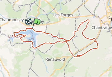
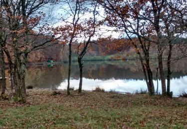
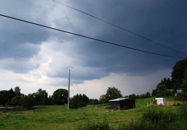
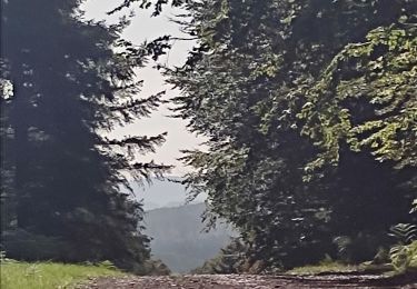
Randonnée Marche de 24 km à découvrir à Grand Est, Vosges, Sanchey. Cette randonnée est proposée par DanielROLLET.

Description

2019 09 12 avec Marie - 9h55 à 16h25
Super temps. Quelques erreurs.

Profil altimétrique

Localisation

Pays :
France
Région :
Grand Est
Département/Province :
Vosges
Commune :
Sanchey
Localité :
Unknown
Départ:(UTM)
303681 ; 5338259 (32U) N.

Randonnées à proximité

Randonnée Marche Chaumousey - Bouzey, côté abbaye  - Photo
Marche
triburemy

Marche

Moyen
Chaumousey, Grand Est, Vosges, France
6,1 km | 7,5 km-effort
1h 40min
Oui
Randonnée Marche Épinal - humbertois les ,2lacs - Photo
Marche
BernardHumeau

Marche

Moyen
Épinal, Grand Est, Vosges, France
7,3 km | 8,9 km-effort
1h 55min
Oui
Randonnée Marche Chantraine - De Chantraine à Bouzey - Photo
Marche
jeanclaude12

Marche

Facile
Chantraine, Grand Est, Vosges, France
14,6 km | 18,2 km-effort
3h 47min
Oui
Randonnée Marche Sanchey - A la Découverte de BOUZEY - Photo
Marche
jeanclaude12

Marche

Très facile
Sanchey, Grand Est, Vosges, France
7,7 km | 9,3 km-effort
2h 4min
Oui
Randonnée Marche Épinal - Aux Champs de Damas - Photo
Marche
jeanclaude12

Marche

Facile
(2)
Épinal, Grand Est, Vosges, France
8,4 km | 10,3 km-effort
2h 17min
Oui
Randonnée Marche Sanchey - Circuit du tour du Lac de Bouzey - Photo
Marche
tracegps

Marche

Facile
Sanchey, Grand Est, Vosges, France
7 km | 8,5 km-effort
1h 40min
Oui
Randonnée V.T.T. Chaumousey - Espace VTT FFC Chemins du Coeur des Vosges - circuit n°87 - Circuit de l'Abbaye - Photo
V.T.T.
tracegps

V.T.T.

Moyen
(1)
Chaumousey, Grand Est, Vosges, France
11,7 km | 14,8 km-effort
1h 0min
Oui
Randonnée V.T.T. Dommartin-aux-Bois - Le Chanot - Photo
V.T.T.
elgatolopez

V.T.T.

Difficile
Dommartin-aux-Bois, Grand Est, Vosges, France
31 km | 38 km-effort
2h 40min
Oui
Randonnée Marche Chantraine - passée  - Photo
Marche
randolea

Marche

Moyen
Chantraine, Grand Est, Vosges, France
5,7 km | 6,9 km-effort
1h 38min
Oui


Fermer
Mes abonnements