![](/images/other/stat-length.png)
![Randonnée Marche Vaudémont - Saxon-Sion 12 300m + 282m (théorique) - Photo](https://media.geolcdn.com/t/1900/400/ext.pjpeg?maxdim=2&url=https%3A%2F%2Fstatic1.geolcdn.com%2Fsiteimages%2Fupload%2Ffiles%2F1553511878bg_sport_marche.png)
Saxon-Sion 12 300m + 282m (théorique)
DanielROLLET
Utilisateur
![Longueur](/images/other/stat-length.png)
Longueur
12,2 km
![Altitude max](https://static1.geolcdn.com/siteimages/upload/files/1508320355ic_sort_altitude_max_24dp.png)
Altitude max
531 m
![Dénivelé positif](https://static1.geolcdn.com/siteimages/upload/files/1508320355ic_sort_den_pos_24dp.png)
Dénivelé positif
282 m
![Km-Effort](/images/other/stat-length.png)
Km-Effort
16 km
![Altitude min](https://static1.geolcdn.com/siteimages/upload/files/1508320355ic_sort_altitude_min_24dp.png)
Altitude min
399 m
![Dénivelé négatif](https://static1.geolcdn.com/siteimages/upload/files/1508320355ic_sort_den_neg_24dp.png)
Dénivelé négatif
281 m
![Boucle](https://static1.geolcdn.com/siteimages/upload/files/16400158638029165_repeat_loop_refresh_sync_direction_icon.png)
Boucle
Oui
Date de création :
2024-01-05 08:24:38.273
Dernière modification :
2024-01-05 19:18:48.946
![Marche](https://static1.geolcdn.com/sitytour/trail-icons/101.png)
3h38
Difficulté : Difficile
![Scannez ce code QR pour ouvrir la randonnée dans l'application SityTrail](https://capi.geolives.com/qq0zvz2zws4bq2lad0pu/sitytour/trails/3908484/qr.png?size=200)
Application GPS de randonnée GRATUITE
À propos
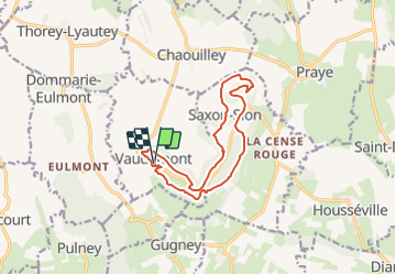
Randonnée Marche de 12,2 km à découvrir à Grand Est, Meurthe-et-Moselle, Vaudémont. Cette randonnée est proposée par DanielROLLET.
Description
2024 01 05 - Avec Marie - 9h25 à 13h25
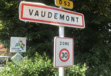
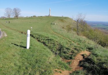
Départ/retour auberge de la Colline (fermée) Vaudémont
Temps gris et frais mais calme
13 820m 313m réels avec les innombrables erreurs dés le départ. Balisage parfois aléatoire voire absent.
Localisation
Pays :
France
Région :
Grand Est
Département/Province :
Meurthe-et-Moselle
Commune :
Vaudémont
Localité :
Unknown
Départ:(Dec)
Départ:(UTM)
282227 ; 5366714 (32U) N.
Commentaires
Randonnées à proximité
![Randonnée A pied Vandeléville - Sentier de la Vieille Chopine - Photo](https://media.geolcdn.com/t/375/260/9681fe6c-fb3d-4dc9-b479-8c06f3f169e6.jpeg&format=jpg&maxdim=2)
![A pied A pied](https://static1.geolcdn.com/sitytour/trail-icons/100.png)
Sentier de la Vieille Chopine
A pied
Facile
Vandeléville,
Grand Est,
Meurthe-et-Moselle,
France
![](/images/other/stat-length.png)
14,8 km | 19,1 km-effort
4h 19min
![](https://static1.geolcdn.com/siteimages/upload/files/16400158638029165_repeat_loop_refresh_sync_direction_icon.png)
Oui
![Randonnée A pied Vaudémont - Circuit Barrès - Brunehaut - Photo](https://media.geolcdn.com/t/375/260/4379cc40-7f33-4534-895d-40998ea52ef9.jpeg&format=jpg&maxdim=2)
![A pied A pied](https://static1.geolcdn.com/sitytour/trail-icons/100.png)
Circuit Barrès - Brunehaut
A pied
Facile
Vaudémont,
Grand Est,
Meurthe-et-Moselle,
France
![](/images/other/stat-length.png)
8,4 km | 10,7 km-effort
2h 26min
![](https://static1.geolcdn.com/siteimages/upload/files/16400158638029165_repeat_loop_refresh_sync_direction_icon.png)
Oui
![Randonnée Marche Saxon-Sion - Sion - Photo](https://media.geolcdn.com/t/375/260/ext.jpg?maxdim=2&url=https%3A%2F%2Fstatic1.geolcdn.com%2Fsiteimages%2Fupload%2Ffiles%2F1553511878bg_sport_marche.png)
![Marche Marche](https://static1.geolcdn.com/sitytour/trail-icons/101.png)
Sion
Marche
Très facile
(1)
Saxon-Sion,
Grand Est,
Meurthe-et-Moselle,
France
![](/images/other/stat-length.png)
12,5 km | 16,2 km-effort
4h 40min
![](https://static1.geolcdn.com/siteimages/upload/files/16400158638029165_repeat_loop_refresh_sync_direction_icon.png)
Oui
![Randonnée Marche Praye - PRAYE - LA COLLINE DE SION-VAUDEMONT - Photo](https://media.geolcdn.com/t/375/260/f6dfea2b-18d4-4541-a670-282ca29a8c57.jpg&format=jpg&maxdim=2)
![Marche Marche](https://static1.geolcdn.com/sitytour/trail-icons/101.png)
PRAYE - LA COLLINE DE SION-VAUDEMONT
Marche
Facile
(1)
Praye,
Grand Est,
Meurthe-et-Moselle,
France
![](/images/other/stat-length.png)
16,6 km | 22 km-effort
8h 52min
![](https://static1.geolcdn.com/siteimages/upload/files/16400158638029165_repeat_loop_refresh_sync_direction_icon.png)
Oui
![Randonnée sport Vaudémont - Vaudemont - Photo](https://media.geolcdn.com/t/375/260/3e0597da-804d-40ff-aac7-534e403227a8.jpg&format=jpg&maxdim=2)
Vaudemont
sport
Très facile
Vaudémont,
Grand Est,
Meurthe-et-Moselle,
France
![](/images/other/stat-length.png)
5 km | 6,4 km-effort
Inconnu
![](https://static1.geolcdn.com/siteimages/upload/files/16400158638029165_repeat_loop_refresh_sync_direction_icon.png)
Oui
![Randonnée Marche Saxon-Sion - sion - Photo](https://media.geolcdn.com/t/375/260/9578318c-4e9b-48e6-b13f-618e356491c1.jpg&format=jpg&maxdim=2)
![Marche Marche](https://static1.geolcdn.com/sitytour/trail-icons/101.png)
sion
Marche
Moyen
Saxon-Sion,
Grand Est,
Meurthe-et-Moselle,
France
![](/images/other/stat-length.png)
12,2 km | 16 km-effort
4h 36min
![](https://static1.geolcdn.com/siteimages/upload/files/16400158638029165_repeat_loop_refresh_sync_direction_icon.png)
Oui
![Randonnée Marche Praye - tour de Sion 54 - Photo](https://media.geolcdn.com/t/375/260/efd9d13b-96a3-4b6c-aa74-e6fa88929e0e.jpg&format=jpg&maxdim=2)
![Marche Marche](https://static1.geolcdn.com/sitytour/trail-icons/101.png)
tour de Sion 54
Marche
Moyen
Praye,
Grand Est,
Meurthe-et-Moselle,
France
![](/images/other/stat-length.png)
18,3 km | 25 km-effort
5h 8min
![](https://static1.geolcdn.com/siteimages/upload/files/16400158638029165_repeat_loop_refresh_sync_direction_icon.png)
Oui
![Randonnée Marche Vaudémont - 2012-01-15 18h02m24 - Photo](https://media.geolcdn.com/t/375/260/ext.jpg?maxdim=2&url=https%3A%2F%2Fservices.sitytrail.com%2FGeolivesWS%2FDownloadMedia.ashx%3FTrailID%3D98704%26Media%3D20120115165929.jpeg)
![Marche Marche](https://static1.geolcdn.com/sitytour/trail-icons/101.png)
2012-01-15 18h02m24
Marche
Facile
Vaudémont,
Grand Est,
Meurthe-et-Moselle,
France
![](/images/other/stat-length.png)
4 km | 4,8 km-effort
1h 4min
![](https://static1.geolcdn.com/siteimages/upload/files/16400158638029165_repeat_loop_refresh_sync_direction_icon.png)
Oui
![Randonnée Marche Vaudémont - Randoguide - Photo](https://media.geolcdn.com/t/375/260/ext.jpg?maxdim=2&url=https%3A%2F%2Fservices.sitytrail.com%2FGeolivesWS%2FDownloadMedia.ashx%3FTrailID%3D90656%26Media%3D20111106174526.jpeg)
![Marche Marche](https://static1.geolcdn.com/sitytour/trail-icons/101.png)
Randoguide
Marche
Moyen
Vaudémont,
Grand Est,
Meurthe-et-Moselle,
France
![](/images/other/stat-length.png)
9,9 km | 12,9 km-effort
2h 45min
![](https://static1.geolcdn.com/siteimages/upload/files/16400158638029165_repeat_loop_refresh_sync_direction_icon.png)
Oui