![](/images/other/stat-length.png)
![Randonnée Marche Brignac-la-Plaine - Brignac la Plaine - Photo](https://media.geolcdn.com/t/1900/400/ext.pjpeg?maxdim=2&url=https%3A%2F%2Fstatic1.geolcdn.com%2Fsiteimages%2Fupload%2Ffiles%2F1553511878bg_sport_marche.png)
Brignac la Plaine
fanthou
Utilisateur
![Longueur](/images/other/stat-length.png)
Longueur
6,3 km
![Altitude max](https://static1.geolcdn.com/siteimages/upload/files/1508320355ic_sort_altitude_max_24dp.png)
Altitude max
216 m
![Dénivelé positif](https://static1.geolcdn.com/siteimages/upload/files/1508320355ic_sort_den_pos_24dp.png)
Dénivelé positif
183 m
![Km-Effort](/images/other/stat-length.png)
Km-Effort
8,8 km
![Altitude min](https://static1.geolcdn.com/siteimages/upload/files/1508320355ic_sort_altitude_min_24dp.png)
Altitude min
116 m
![Dénivelé négatif](https://static1.geolcdn.com/siteimages/upload/files/1508320355ic_sort_den_neg_24dp.png)
Dénivelé négatif
183 m
![Boucle](https://static1.geolcdn.com/siteimages/upload/files/16400158638029165_repeat_loop_refresh_sync_direction_icon.png)
Boucle
Oui
Date de création :
2014-12-10 00:00:00.0
Dernière modification :
2014-12-10 00:00:00.0
![Marche](https://static1.geolcdn.com/sitytour/trail-icons/101.png)
1h53
Difficulté : Facile
![Scannez ce code QR pour ouvrir la randonnée dans l'application SityTrail](https://capi.geolives.com/qq0zvz2zws4bq2lad0pu/sitytour/trails/390260/qr.png?size=200)
Application GPS de randonnée GRATUITE
À propos
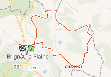
Randonnée Marche de 6,3 km à découvrir à Nouvelle-Aquitaine, Corrèze, Brignac-la-Plaine. Cette randonnée est proposée par fanthou.
Description
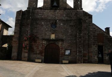
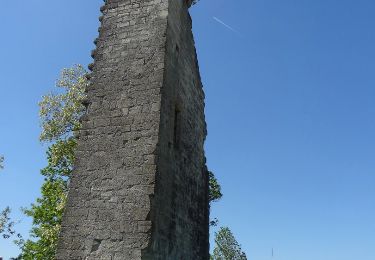
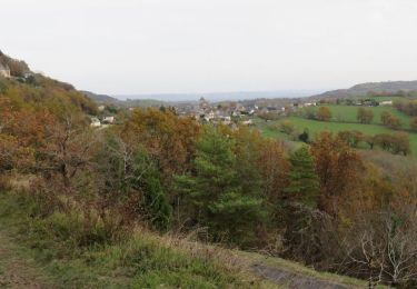
Départ de Brignac, place de l'église. A voir en chemin : retable, pigeonnier rond et croix. Vue sur le château de Perpezac et le puy d'Yssandon.
Localisation
Pays :
France
Région :
Nouvelle-Aquitaine
Département/Province :
Corrèze
Commune :
Brignac-la-Plaine
Localité :
Unknown
Départ:(Dec)
Départ:(UTM)
369571 ; 5005252 (31T) N.
Commentaires
Randonnées à proximité
![Randonnée Marche Perpezac-le-Blanc - perpezac_3 - Photo](https://media.geolcdn.com/t/375/260/ext.jpg?maxdim=2&url=https%3A%2F%2Fstatic1.geolcdn.com%2Fsiteimages%2Fupload%2Ffiles%2F1553511878bg_sport_marche.png)
![Marche Marche](https://static1.geolcdn.com/sitytour/trail-icons/101.png)
perpezac_3
Marche
Moyen
(1)
Perpezac-le-Blanc,
Nouvelle-Aquitaine,
Corrèze,
France
![](/images/other/stat-length.png)
7,4 km | 10,3 km-effort
2h 13min
![](https://static1.geolcdn.com/siteimages/upload/files/16400158638029165_repeat_loop_refresh_sync_direction_icon.png)
Oui
![Randonnée Marche Mansac - Fred BC Mansac - Photo](https://media.geolcdn.com/t/375/260/fec492d1-7eb9-438a-9e7f-daf1255557d0.jpg&format=jpg&maxdim=2)
![Marche Marche](https://static1.geolcdn.com/sitytour/trail-icons/101.png)
Fred BC Mansac
Marche
Moyen
Mansac,
Nouvelle-Aquitaine,
Corrèze,
France
![](/images/other/stat-length.png)
8,6 km | 11,9 km-effort
3h 3min
![](https://static1.geolcdn.com/siteimages/upload/files/16400158638029165_repeat_loop_refresh_sync_direction_icon.png)
Oui
![Randonnée Marche Yssandon - La Tour d'Yssandon - Photo](https://media.geolcdn.com/t/375/260/ext.jpg?maxdim=2&url=https%3A%2F%2Fservices.sitytrail.com%2FGeolivesWS%2FDownloadMedia.ashx%3FTrailID%3D301286%26Media%3D09887f08-3b27-474d-a27a-f8eff365f188.JPG)
![Marche Marche](https://static1.geolcdn.com/sitytour/trail-icons/101.png)
La Tour d'Yssandon
Marche
Très facile
Yssandon,
Nouvelle-Aquitaine,
Corrèze,
France
![](/images/other/stat-length.png)
6,2 km | 9 km-effort
1h 47min
![](https://static1.geolcdn.com/siteimages/upload/files/16400158638029165_repeat_loop_refresh_sync_direction_icon.png)
Oui
![Randonnée Marche Perpezac-le-Blanc - Circuit de la mine - Photo](https://media.geolcdn.com/t/375/260/ext.jpg?maxdim=2&url=https%3A%2F%2Fservices.sitytrail.com%2FGeolivesWS%2FDownloadMedia.ashx%3FTrailID%3D301273%26Media%3D742a7169-602c-416b-991f-cfd8a4759a8e.jpg)
![Marche Marche](https://static1.geolcdn.com/sitytour/trail-icons/101.png)
Circuit de la mine
Marche
Moyen
Perpezac-le-Blanc,
Nouvelle-Aquitaine,
Corrèze,
France
![](/images/other/stat-length.png)
6,7 km | 9,1 km-effort
2h 0min
![](https://static1.geolcdn.com/siteimages/upload/files/16400158638029165_repeat_loop_refresh_sync_direction_icon.png)
Oui
![Randonnée Marche Brignac-la-Plaine - Brignac - Photo](https://media.geolcdn.com/t/375/260/ext.jpg?maxdim=2&url=https%3A%2F%2Fstatic1.geolcdn.com%2Fsiteimages%2Fupload%2Ffiles%2F1553511878bg_sport_marche.png)
![Marche Marche](https://static1.geolcdn.com/sitytour/trail-icons/101.png)
Brignac
Marche
Facile
Brignac-la-Plaine,
Nouvelle-Aquitaine,
Corrèze,
France
![](/images/other/stat-length.png)
3,6 km | 4,8 km-effort
56min
![](https://static1.geolcdn.com/siteimages/upload/files/16400158638029165_repeat_loop_refresh_sync_direction_icon.png)
Non
![Randonnée Vélo de route Yssandon - yssandon3 - Photo](https://media.geolcdn.com/t/375/260/ext.jpg?maxdim=2&url=https%3A%2F%2Fstatic1.geolcdn.com%2Fsiteimages%2Fupload%2Ffiles%2F1524743154velo.jpg)
![Vélo de route Vélo de route](https://static1.geolcdn.com/sitytour/trail-icons/201.png)
yssandon3
Vélo de route
Moyen
Yssandon,
Nouvelle-Aquitaine,
Corrèze,
France
![](/images/other/stat-length.png)
27 km | 34 km-effort
1h 25min
![](https://static1.geolcdn.com/siteimages/upload/files/16400158638029165_repeat_loop_refresh_sync_direction_icon.png)
Oui
![Randonnée Vélo de route Yssandon - brive - Photo](https://media.geolcdn.com/t/375/260/ext.jpg?maxdim=2&url=https%3A%2F%2Fstatic1.geolcdn.com%2Fsiteimages%2Fupload%2Ffiles%2F1524743154velo.jpg)
![Vélo de route Vélo de route](https://static1.geolcdn.com/sitytour/trail-icons/201.png)
brive
Vélo de route
Moyen
Yssandon,
Nouvelle-Aquitaine,
Corrèze,
France
![](/images/other/stat-length.png)
23 km | 27 km-effort
1h 9min
![](https://static1.geolcdn.com/siteimages/upload/files/16400158638029165_repeat_loop_refresh_sync_direction_icon.png)
Non
![Randonnée Marche Brignac-la-Plaine - Brignac la plaine-Les coteaux - Photo](https://media.geolcdn.com/t/375/260/ext.jpg?maxdim=2&url=https%3A%2F%2Fstatic1.geolcdn.com%2Fsiteimages%2Fupload%2Ffiles%2F1553511878bg_sport_marche.png)
![Marche Marche](https://static1.geolcdn.com/sitytour/trail-icons/101.png)
Brignac la plaine-Les coteaux
Marche
Facile
Brignac-la-Plaine,
Nouvelle-Aquitaine,
Corrèze,
France
![](/images/other/stat-length.png)
10,3 km | 13,6 km-effort
2h 56min
![](https://static1.geolcdn.com/siteimages/upload/files/16400158638029165_repeat_loop_refresh_sync_direction_icon.png)
Oui
![Randonnée Marche Cublac - Les mines long - Photo](https://media.geolcdn.com/t/375/260/ext.jpg?maxdim=2&url=https%3A%2F%2Fstatic1.geolcdn.com%2Fsiteimages%2Fupload%2Ffiles%2F1553511878bg_sport_marche.png)
![Marche Marche](https://static1.geolcdn.com/sitytour/trail-icons/101.png)
Les mines long
Marche
Moyen
Cublac,
Nouvelle-Aquitaine,
Corrèze,
France
![](/images/other/stat-length.png)
8,3 km | 11,1 km-effort
2h 52min
![](https://static1.geolcdn.com/siteimages/upload/files/16400158638029165_repeat_loop_refresh_sync_direction_icon.png)
Oui