![](/images/other/stat-length.png)
![Randonnée Marche Plombières-les-Bains - Le Chemin des Pierres - Photo](https://media.geolcdn.com/t/1900/400/ext.pjpeg?maxdim=2&url=https%3A%2F%2Fservices.sitytrail.com%2FGeolivesWS%2FDownloadMedia.ashx%3FTrailID%3D389664%26Media%3Dfix__20150224151633.jpg)
Le Chemin des Pierres
jeanclaude12
Utilisateur
![Longueur](/images/other/stat-length.png)
![Altitude max](https://static1.geolcdn.com/siteimages/upload/files/1508320355ic_sort_altitude_max_24dp.png)
![Dénivelé positif](https://static1.geolcdn.com/siteimages/upload/files/1508320355ic_sort_den_pos_24dp.png)
![Km-Effort](/images/other/stat-length.png)
![Altitude min](https://static1.geolcdn.com/siteimages/upload/files/1508320355ic_sort_altitude_min_24dp.png)
![Dénivelé négatif](https://static1.geolcdn.com/siteimages/upload/files/1508320355ic_sort_den_neg_24dp.png)
![Boucle](https://static1.geolcdn.com/siteimages/upload/files/16400158638029165_repeat_loop_refresh_sync_direction_icon.png)
![Marche](https://static1.geolcdn.com/sitytour/trail-icons/101.png)
3h08
Difficulté : Facile
![Scannez ce code QR pour ouvrir la randonnée dans l'application SityTrail](https://capi.geolives.com/qq0zvz2zws4bq2lad0pu/sitytour/trails/389664/qr.png?size=200)
Application GPS de randonnée GRATUITE
À propos
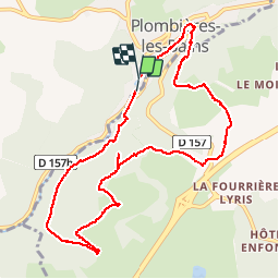
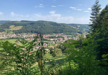
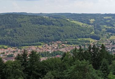
Randonnée Marche de 10,2 km à découvrir à Grand Est, Vosges, Plombières-les-Bains. Cette randonnée est proposée par jeanclaude12.
Description
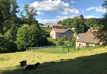
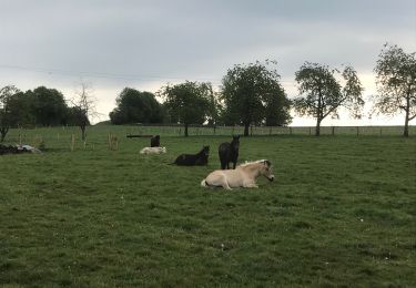
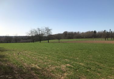
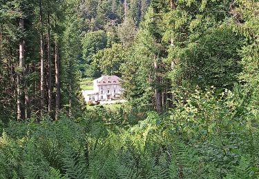
Au départ du Casino de Plombières (Ancienne Gare), cet agréable circuit grimpe doucement sous le Bois de Ramanxard vers le Moulin Taqueré, longe ce bois vers la Croix Rouge, passe le Petit Moulin et le Bolha et rejoint Plombières-les-Bains en surplombant le Parc Rivoli.
Localisation
Commentaires
Randonnées à proximité
![Randonnée Marche Plombières-les-Bains - plombières et les Ruaux - Photo](https://media.geolcdn.com/t/375/260/ext.jpg?maxdim=2&url=https%3A%2F%2Fservices.sitytrail.com%2FGeolivesWS%2FDownloadMedia.ashx%3FTrailID%3D558197%26Media%3D20160424103736.jpg)
![Marche Marche](https://static1.geolcdn.com/sitytour/trail-icons/101.png)
Marche
![](/images/other/stat-length.png)
![](https://static1.geolcdn.com/siteimages/upload/files/16400158638029165_repeat_loop_refresh_sync_direction_icon.png)
![Randonnée Marche nordique Plombières-les-Bains - plombieres20221008 - Photo](https://media.geolcdn.com/t/375/260/79458fa7-7f9d-4ffa-9799-65637f84fe4b.jpg&format=jpg&maxdim=2)
![Marche nordique Marche nordique](https://static1.geolcdn.com/sitytour/trail-icons/102.png)
Marche nordique
![](/images/other/stat-length.png)
![](https://static1.geolcdn.com/siteimages/upload/files/16400158638029165_repeat_loop_refresh_sync_direction_icon.png)
![Randonnée Randonnée équestre Fougerolles-Saint-Valbert - Moulin taquere 7kms - Photo](https://media.geolcdn.com/t/375/260/4908ffe4-012c-4ca8-910b-89ab7d96d808.jpg&format=jpg&maxdim=2)
![Randonnée équestre Randonnée équestre](https://static1.geolcdn.com/sitytour/trail-icons/301.png)
Randonnée équestre
![](/images/other/stat-length.png)
![](https://static1.geolcdn.com/siteimages/upload/files/16400158638029165_repeat_loop_refresh_sync_direction_icon.png)
![Randonnée Marche Fougerolles-Saint-Valbert - Balade poney 6kms - Photo](https://media.geolcdn.com/t/375/260/1f2dc543-5f84-4925-9489-21df8a97fbf2.jpg&format=jpg&maxdim=2)
![Marche Marche](https://static1.geolcdn.com/sitytour/trail-icons/101.png)
Marche
![](/images/other/stat-length.png)
![](https://static1.geolcdn.com/siteimages/upload/files/16400158638029165_repeat_loop_refresh_sync_direction_icon.png)
![Randonnée Randonnée équestre Fougerolles-Saint-Valbert - Balade 1h vers chez le poix - Photo](https://media.geolcdn.com/t/375/260/505f2317-5f10-48d7-8d7f-f8c2631381af.jpg&format=jpg&maxdim=2)
![Randonnée équestre Randonnée équestre](https://static1.geolcdn.com/sitytour/trail-icons/301.png)
Randonnée équestre
![](/images/other/stat-length.png)
![](https://static1.geolcdn.com/siteimages/upload/files/16400158638029165_repeat_loop_refresh_sync_direction_icon.png)
![Randonnée Marche Plombières-les-Bains - 30-07-23 Plombières : circuit jaune n°9 - Photo](https://media.geolcdn.com/t/375/260/c8d7f0dc-06b9-49d4-b934-200f7715b734.jpg&format=jpg&maxdim=2)
![Marche Marche](https://static1.geolcdn.com/sitytour/trail-icons/101.png)
Marche
![](/images/other/stat-length.png)
![](https://static1.geolcdn.com/siteimages/upload/files/16400158638029165_repeat_loop_refresh_sync_direction_icon.png)
![Randonnée Marche Le Val-d'Ajol - Val d’Ajol - Photo](https://media.geolcdn.com/t/375/260/51840968-33fb-4220-bfd0-0c8643bc6107.jpg&format=jpg&maxdim=2)
![Marche Marche](https://static1.geolcdn.com/sitytour/trail-icons/101.png)
Marche
![](/images/other/stat-length.png)
![](https://static1.geolcdn.com/siteimages/upload/files/16400158638029165_repeat_loop_refresh_sync_direction_icon.png)
![Randonnée Marche Plombières-les-Bains - Plombieres - Photo](https://media.geolcdn.com/t/375/260/52b52bb9-3906-40e8-bf5c-dbb553773223.jpg&format=jpg&maxdim=2)
![Marche Marche](https://static1.geolcdn.com/sitytour/trail-icons/101.png)
Marche
![](/images/other/stat-length.png)
![](https://static1.geolcdn.com/siteimages/upload/files/16400158638029165_repeat_loop_refresh_sync_direction_icon.png)
![Randonnée Marche Le Val-d'Ajol - 10-06-23 Val d'Ajol, Feuillée Dorothée, Feuillée Nouvelle - Photo](https://media.geolcdn.com/t/375/260/42139384-3c60-46a3-bf22-256b647e208a.jpg&format=jpg&maxdim=2)
![Marche Marche](https://static1.geolcdn.com/sitytour/trail-icons/101.png)
Marche
![](/images/other/stat-length.png)
![](https://static1.geolcdn.com/siteimages/upload/files/16400158638029165_repeat_loop_refresh_sync_direction_icon.png)