![](/images/other/stat-length.png)
![Randonnée Marche Saint-Héand - St Héand par Nuey - Photo](https://media.geolcdn.com/t/1900/400/ext.pjpeg?maxdim=2&url=https%3A%2F%2Fstatic1.geolcdn.com%2Fsiteimages%2Fupload%2Ffiles%2F1553511878bg_sport_marche.png)
St Héand par Nuey
yvon42
Utilisateur
![Longueur](/images/other/stat-length.png)
Longueur
8 km
![Altitude max](https://static1.geolcdn.com/siteimages/upload/files/1508320355ic_sort_altitude_max_24dp.png)
Altitude max
701 m
![Dénivelé positif](https://static1.geolcdn.com/siteimages/upload/files/1508320355ic_sort_den_pos_24dp.png)
Dénivelé positif
261 m
![Km-Effort](/images/other/stat-length.png)
Km-Effort
11,5 km
![Altitude min](https://static1.geolcdn.com/siteimages/upload/files/1508320355ic_sort_altitude_min_24dp.png)
Altitude min
556 m
![Dénivelé négatif](https://static1.geolcdn.com/siteimages/upload/files/1508320355ic_sort_den_neg_24dp.png)
Dénivelé négatif
274 m
![Boucle](https://static1.geolcdn.com/siteimages/upload/files/16400158638029165_repeat_loop_refresh_sync_direction_icon.png)
Boucle
Oui
Date de création :
2023-12-17 09:47:56.434
Dernière modification :
2023-12-17 13:30:21.755
![Marche](https://static1.geolcdn.com/sitytour/trail-icons/101.png)
3h06
Difficulté : Facile
![Scannez ce code QR pour ouvrir la randonnée dans l'application SityTrail](https://capi.geolives.com/qq0zvz2zws4bq2lad0pu/sitytour/trails/3895661/qr.png?size=200)
Application GPS de randonnée GRATUITE
À propos
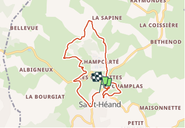
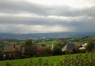
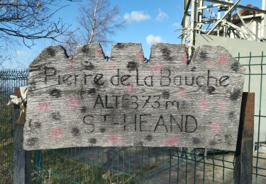
Randonnée Marche de 8 km à découvrir à Auvergne-Rhône-Alpes, Loire, Saint-Héand. Cette randonnée est proposée par yvon42.
Description
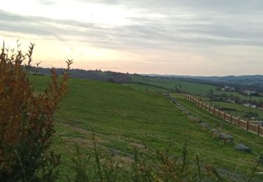
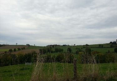
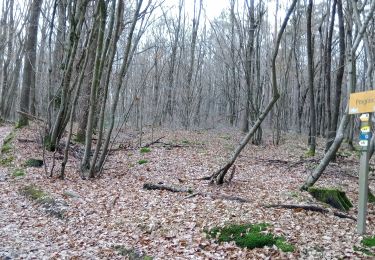
petite randonnée sympa dans,réelle difficulté. A faire un après-midi ou en partant en fin de matinée pendant l'hiver. Petit dénivelé positif et négatif.
Localisation
Pays :
France
Région :
Auvergne-Rhône-Alpes
Département/Province :
Loire
Commune :
Saint-Héand
Localité :
Unknown
Départ:(Dec)
Départ:(UTM)
607372 ; 5043004 (31T) N.
Commentaires
Randonnées à proximité
![Randonnée Marche Saint-Héand - St Heand, Montrond, Mont Morin, Pierre de la Bauche et retour St Heand - Photo](https://media.geolcdn.com/t/375/260/ext.jpg?maxdim=2&url=https%3A%2F%2Fstatic1.geolcdn.com%2Fsiteimages%2Fupload%2Ffiles%2F1553511878bg_sport_marche.png)
![Marche Marche](https://static1.geolcdn.com/sitytour/trail-icons/101.png)
St Heand, Montrond, Mont Morin, Pierre de la Bauche et retour St Heand
Marche
Moyen
(1)
Saint-Héand,
Auvergne-Rhône-Alpes,
Loire,
France
![](/images/other/stat-length.png)
16 km | 23 km-effort
5h 20min
![](https://static1.geolcdn.com/siteimages/upload/files/16400158638029165_repeat_loop_refresh_sync_direction_icon.png)
Oui
![Randonnée Marche Saint-Bonnet-les-Oules - Saint-Bonnet-les-Oules du 26-12-2022 - Photo](https://media.geolcdn.com/t/375/260/b0909c52-48d0-4fb3-a021-6e2066fe45fd.jpg&format=jpg&maxdim=2)
![Marche Marche](https://static1.geolcdn.com/sitytour/trail-icons/101.png)
Saint-Bonnet-les-Oules du 26-12-2022
Marche
Difficile
Saint-Bonnet-les-Oules,
Auvergne-Rhône-Alpes,
Loire,
France
![](/images/other/stat-length.png)
10,8 km | 14,5 km-effort
2h 17min
![](https://static1.geolcdn.com/siteimages/upload/files/16400158638029165_repeat_loop_refresh_sync_direction_icon.png)
Oui
![Randonnée Marche Sorbiers - sorbiers 23/2 - Photo](https://media.geolcdn.com/t/375/260/ext.jpg?maxdim=2&url=https%3A%2F%2Fstatic1.geolcdn.com%2Fsiteimages%2Fupload%2Ffiles%2F1553511878bg_sport_marche.png)
![Marche Marche](https://static1.geolcdn.com/sitytour/trail-icons/101.png)
sorbiers 23/2
Marche
Difficile
(1)
Sorbiers,
Auvergne-Rhône-Alpes,
Loire,
France
![](/images/other/stat-length.png)
23 km | 35 km-effort
4h 36min
![](https://static1.geolcdn.com/siteimages/upload/files/16400158638029165_repeat_loop_refresh_sync_direction_icon.png)
Oui
![Randonnée Marche Sorbiers - sorbiers - Photo](https://media.geolcdn.com/t/375/260/ext.jpg?maxdim=2&url=https%3A%2F%2Fstatic1.geolcdn.com%2Fsiteimages%2Fupload%2Ffiles%2F1553511878bg_sport_marche.png)
![Marche Marche](https://static1.geolcdn.com/sitytour/trail-icons/101.png)
sorbiers
Marche
Difficile
(1)
Sorbiers,
Auvergne-Rhône-Alpes,
Loire,
France
![](/images/other/stat-length.png)
23 km | 36 km-effort
4h 46min
![](https://static1.geolcdn.com/siteimages/upload/files/16400158638029165_repeat_loop_refresh_sync_direction_icon.png)
Oui
![Randonnée Marche Sorbiers - sorbiers-st christo - valfeury - Photo](https://media.geolcdn.com/t/375/260/ext.jpg?maxdim=2&url=https%3A%2F%2Fstatic1.geolcdn.com%2Fsiteimages%2Fupload%2Ffiles%2F1553511878bg_sport_marche.png)
![Marche Marche](https://static1.geolcdn.com/sitytour/trail-icons/101.png)
sorbiers-st christo - valfeury
Marche
Moyen
(1)
Sorbiers,
Auvergne-Rhône-Alpes,
Loire,
France
![](/images/other/stat-length.png)
23 km | 35 km-effort
4h 32min
![](https://static1.geolcdn.com/siteimages/upload/files/16400158638029165_repeat_loop_refresh_sync_direction_icon.png)
Oui
![Randonnée Marche Saint-Héand - izzy - Photo](https://media.geolcdn.com/t/375/260/ext.jpg?maxdim=2&url=https%3A%2F%2Fservices.sitytrail.com%2FGeolivesWS%2FDownloadMedia.ashx%3FTrailID%3D230294%26Media%3Dfix__20131101155052.jpg)
![Marche Marche](https://static1.geolcdn.com/sitytour/trail-icons/101.png)
izzy
Marche
Facile
Saint-Héand,
Auvergne-Rhône-Alpes,
Loire,
France
![](/images/other/stat-length.png)
5,9 km | 8,1 km-effort
1h 10min
![](https://static1.geolcdn.com/siteimages/upload/files/16400158638029165_repeat_loop_refresh_sync_direction_icon.png)
Oui
![Randonnée Marche Saint-Héand - tour de st heand - Photo](https://media.geolcdn.com/t/375/260/ext.jpg?maxdim=2&url=https%3A%2F%2Fservices.sitytrail.com%2FGeolivesWS%2FDownloadMedia.ashx%3FTrailID%3D158199%26Media%3D20121014153946.jpeg)
![Marche Marche](https://static1.geolcdn.com/sitytour/trail-icons/101.png)
tour de st heand
Marche
Très facile
Saint-Héand,
Auvergne-Rhône-Alpes,
Loire,
France
![](/images/other/stat-length.png)
13,2 km | 18,3 km-effort
3h 15min
![](https://static1.geolcdn.com/siteimages/upload/files/16400158638029165_repeat_loop_refresh_sync_direction_icon.png)
Oui
![Randonnée Marche Saint-Héand - Saint-héand, la pierre de la bauche, les alisiers, le rivollier, les baraques, Saint-héand - Photo](https://media.geolcdn.com/t/375/260/a6cd303b-9223-49c8-a72d-e215cf50d4f5.jpg&format=jpg&maxdim=2)
![Marche Marche](https://static1.geolcdn.com/sitytour/trail-icons/101.png)
Saint-héand, la pierre de la bauche, les alisiers, le rivollier, les baraques...
Marche
Moyen
Saint-Héand,
Auvergne-Rhône-Alpes,
Loire,
France
![](/images/other/stat-length.png)
12,3 km | 17,8 km-effort
2h 53min
![](https://static1.geolcdn.com/siteimages/upload/files/16400158638029165_repeat_loop_refresh_sync_direction_icon.png)
Oui
![Randonnée Marche La Fouillouse - la Fouillouse du 23-12-2022 - Photo](https://media.geolcdn.com/t/375/260/6bb4cea8-ed48-4347-8677-7ad69837607c.jpg&format=jpg&maxdim=2)
![Marche Marche](https://static1.geolcdn.com/sitytour/trail-icons/101.png)
la Fouillouse du 23-12-2022
Marche
Difficile
La Fouillouse,
Auvergne-Rhône-Alpes,
Loire,
France
![](/images/other/stat-length.png)
11 km | 14,7 km-effort
2h 24min
![](https://static1.geolcdn.com/siteimages/upload/files/16400158638029165_repeat_loop_refresh_sync_direction_icon.png)
Oui