![](/images/other/stat-length.png)
![Randonnée Randonnée équestre Saint-Germain-au-Mont-d'Or - SGMO MONTAGNARDS Aller Chass MACHY GLANDE 15K 20KF - Photo](https://media.geolcdn.com/t/1900/400/ext.pjpeg?maxdim=2&url=https%3A%2F%2Fstatic1.geolcdn.com%2Fsiteimages%2Fupload%2Ffiles%2F1524743154cheval.jpg)
SGMO MONTAGNARDS Aller Chass MACHY GLANDE 15K 20KF
azipat
Utilisateur
![Longueur](/images/other/stat-length.png)
Longueur
15,2 km
![Altitude max](https://static1.geolcdn.com/siteimages/upload/files/1508320355ic_sort_altitude_max_24dp.png)
Altitude max
592 m
![Dénivelé positif](https://static1.geolcdn.com/siteimages/upload/files/1508320355ic_sort_den_pos_24dp.png)
Dénivelé positif
465 m
![Km-Effort](/images/other/stat-length.png)
Km-Effort
21 km
![Altitude min](https://static1.geolcdn.com/siteimages/upload/files/1508320355ic_sort_altitude_min_24dp.png)
Altitude min
196 m
![Dénivelé négatif](https://static1.geolcdn.com/siteimages/upload/files/1508320355ic_sort_den_neg_24dp.png)
Dénivelé négatif
217 m
![Boucle](https://static1.geolcdn.com/siteimages/upload/files/16400158638029165_repeat_loop_refresh_sync_direction_icon.png)
Boucle
Non
Date de création :
2023-12-15 19:42:42.081
Dernière modification :
2024-01-17 13:31:50.784
![Randonnée équestre](https://static1.geolcdn.com/sitytour/trail-icons/301.png)
2h42
Difficulté : Moyen
![Scannez ce code QR pour ouvrir la randonnée dans l'application SityTrail](https://capi.geolives.com/qq0zvz2zws4bq2lad0pu/sitytour/trails/3893979/qr.png?size=200)
Application GPS de randonnée GRATUITE
À propos
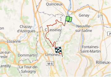
Randonnée Randonnée équestre de 15,2 km à découvrir à Auvergne-Rhône-Alpes, Métropole de Lyon, Saint-Germain-au-Mont-d'Or. Cette randonnée est proposée par azipat.
Description
Beaucoup de route
Localisation
Pays :
France
Région :
Auvergne-Rhône-Alpes
Département/Province :
Métropole de Lyon
Commune :
Saint-Germain-au-Mont-d'Or
Localité :
Unknown
Départ:(Dec)
Départ:(UTM)
639445 ; 5082278 (31T) N.
Commentaires
Randonnées à proximité
![Randonnée Marche Couzon-au-Mont-d'Or - Tour de Couzon par les crêtes - Photo](https://media.geolcdn.com/t/375/260/ext.jpg?maxdim=2&url=https%3A%2F%2Fservices.sitytrail.com%2FGeolivesWS%2FDownloadMedia.ashx%3FTrailID%3D626228%26Media%3D20160904183041.jpg)
![Marche Marche](https://static1.geolcdn.com/sitytour/trail-icons/101.png)
Tour de Couzon par les crêtes
Marche
Difficile
(2)
Couzon-au-Mont-d'Or,
Auvergne-Rhône-Alpes,
Métropole de Lyon,
France
![](/images/other/stat-length.png)
6,5 km | 10,7 km-effort
2h 5min
![](https://static1.geolcdn.com/siteimages/upload/files/16400158638029165_repeat_loop_refresh_sync_direction_icon.png)
Oui
![Randonnée Randonnée équestre Saint-Germain-au-Mont-d'Or - J LIB SGGlaMontagnard Long - Photo](https://media.geolcdn.com/t/375/260/ext.jpg?maxdim=2&url=https%3A%2F%2Fstatic1.geolcdn.com%2Fsiteimages%2Fupload%2Ffiles%2F1524743154cheval.jpg)
![Randonnée équestre Randonnée équestre](https://static1.geolcdn.com/sitytour/trail-icons/301.png)
J LIB SGGlaMontagnard Long
Randonnée équestre
Difficile
(1)
Saint-Germain-au-Mont-d'Or,
Auvergne-Rhône-Alpes,
Métropole de Lyon,
France
![](/images/other/stat-length.png)
27 km | 39 km-effort
5h 8min
![](https://static1.geolcdn.com/siteimages/upload/files/16400158638029165_repeat_loop_refresh_sync_direction_icon.png)
Oui
![Randonnée Randonnée équestre Saint-Germain-au-Mont-d'Or - A supp test DD1-3 Mare tab Chair Tab Lav - Photo](https://media.geolcdn.com/t/375/260/ext.jpg?maxdim=2&url=https%3A%2F%2Fstatic1.geolcdn.com%2Fsiteimages%2Fupload%2Ffiles%2F1524743154cheval.jpg)
![Randonnée équestre Randonnée équestre](https://static1.geolcdn.com/sitytour/trail-icons/301.png)
A supp test DD1-3 Mare tab Chair Tab Lav
Randonnée équestre
Facile
(2)
Saint-Germain-au-Mont-d'Or,
Auvergne-Rhône-Alpes,
Métropole de Lyon,
France
![](/images/other/stat-length.png)
12,3 km | 19 km-effort
2h 30min
![](https://static1.geolcdn.com/siteimages/upload/files/16400158638029165_repeat_loop_refresh_sync_direction_icon.png)
Oui
![Randonnée Randonnée équestre Saint-Germain-au-Mont-d'Or - J LIB SGChaGlaMontagnard 27k 40kf - Photo](https://media.geolcdn.com/t/375/260/ext.jpg?maxdim=2&url=https%3A%2F%2Fstatic1.geolcdn.com%2Fsiteimages%2Fupload%2Ffiles%2F1524743154cheval.jpg)
![Randonnée équestre Randonnée équestre](https://static1.geolcdn.com/sitytour/trail-icons/301.png)
J LIB SGChaGlaMontagnard 27k 40kf
Randonnée équestre
Difficile
(1)
Saint-Germain-au-Mont-d'Or,
Auvergne-Rhône-Alpes,
Métropole de Lyon,
France
![](/images/other/stat-length.png)
27 km | 40 km-effort
5h 13min
![](https://static1.geolcdn.com/siteimages/upload/files/16400158638029165_repeat_loop_refresh_sync_direction_icon.png)
Oui
![Randonnée Randonnée équestre Chasselay - chasselay florian alain - Photo](https://media.geolcdn.com/t/375/260/ext.jpg?maxdim=2&url=https%3A%2F%2Fstatic1.geolcdn.com%2Fsiteimages%2Fupload%2Ffiles%2F1524743154cheval.jpg)
![Randonnée équestre Randonnée équestre](https://static1.geolcdn.com/sitytour/trail-icons/301.png)
chasselay florian alain
Randonnée équestre
Facile
(1)
Chasselay,
Auvergne-Rhône-Alpes,
Rhône,
France
![](/images/other/stat-length.png)
13,3 km | 17,3 km-effort
2h 16min
![](https://static1.geolcdn.com/siteimages/upload/files/16400158638029165_repeat_loop_refresh_sync_direction_icon.png)
Oui
![Randonnée Randonnée équestre Saint-Germain-au-Mont-d'Or - J LIB SGChaGlaMontagnard Long - Photo](https://media.geolcdn.com/t/375/260/ext.jpg?maxdim=2&url=https%3A%2F%2Fstatic1.geolcdn.com%2Fsiteimages%2Fupload%2Ffiles%2F1524743154cheval.jpg)
![Randonnée équestre Randonnée équestre](https://static1.geolcdn.com/sitytour/trail-icons/301.png)
J LIB SGChaGlaMontagnard Long
Randonnée équestre
Très difficile
(1)
Saint-Germain-au-Mont-d'Or,
Auvergne-Rhône-Alpes,
Métropole de Lyon,
France
![](/images/other/stat-length.png)
29 km | 43 km-effort
5h 39min
![](https://static1.geolcdn.com/siteimages/upload/files/16400158638029165_repeat_loop_refresh_sync_direction_icon.png)
Oui
![Randonnée Randonnée équestre Saint-Germain-au-Mont-d'Or - DC 4 SGMO Mar Vel Vigne Table 14km 21kf - Photo](https://media.geolcdn.com/t/375/260/ext.jpg?maxdim=2&url=https%3A%2F%2Fstatic1.geolcdn.com%2Fsiteimages%2Fupload%2Ffiles%2F1524743154cheval.jpg)
![Randonnée équestre Randonnée équestre](https://static1.geolcdn.com/sitytour/trail-icons/301.png)
DC 4 SGMO Mar Vel Vigne Table 14km 21kf
Randonnée équestre
Moyen
(1)
Saint-Germain-au-Mont-d'Or,
Auvergne-Rhône-Alpes,
Métropole de Lyon,
France
![](/images/other/stat-length.png)
13,7 km | 21 km-effort
2h 43min
![](https://static1.geolcdn.com/siteimages/upload/files/16400158638029165_repeat_loop_refresh_sync_direction_icon.png)
Oui
![Randonnée Randonnée équestre Saint-Germain-au-Mont-d'Or - DD1-3 Mare tab Chair Tab Lav - Photo](https://media.geolcdn.com/t/375/260/ext.jpg?maxdim=2&url=https%3A%2F%2Fstatic1.geolcdn.com%2Fsiteimages%2Fupload%2Ffiles%2F1524743154cheval.jpg)
![Randonnée équestre Randonnée équestre](https://static1.geolcdn.com/sitytour/trail-icons/301.png)
DD1-3 Mare tab Chair Tab Lav
Randonnée équestre
Facile
(2)
Saint-Germain-au-Mont-d'Or,
Auvergne-Rhône-Alpes,
Métropole de Lyon,
France
![](/images/other/stat-length.png)
12,3 km | 19,1 km-effort
2h 30min
![](https://static1.geolcdn.com/siteimages/upload/files/16400158638029165_repeat_loop_refresh_sync_direction_icon.png)
Oui
![Randonnée A pied Saint-Germain-au-Mont-d'Or - Grand Tour des Monts d'Or - Photo](https://media.geolcdn.com/t/375/260/50138287-4896-425f-9aee-b9551d3b8f65.jpeg&format=jpg&maxdim=2)
![A pied A pied](https://static1.geolcdn.com/sitytour/trail-icons/100.png)
Grand Tour des Monts d'Or
A pied
Moyen
Saint-Germain-au-Mont-d'Or,
Auvergne-Rhône-Alpes,
Métropole de Lyon,
France
![](/images/other/stat-length.png)
17,4 km | 27 km-effort
6h 9min
![](https://static1.geolcdn.com/siteimages/upload/files/16400158638029165_repeat_loop_refresh_sync_direction_icon.png)
Non