![](/images/other/stat-length.png)
![Randonnée Marche Montauroux - Le lac de Saint Cassien et la réserve biologique de Fondurane - Photo](https://media.geolcdn.com/t/1900/400/624cf528-9da6-482e-b332-cea4bc123d23.jpg&format=pjpeg&maxdim=2)
Le lac de Saint Cassien et la réserve biologique de Fondurane
boulinevelyne
Utilisateur
![Longueur](/images/other/stat-length.png)
Longueur
13,7 km
![Altitude max](https://static1.geolcdn.com/siteimages/upload/files/1508320355ic_sort_altitude_max_24dp.png)
Altitude max
346 m
![Dénivelé positif](https://static1.geolcdn.com/siteimages/upload/files/1508320355ic_sort_den_pos_24dp.png)
Dénivelé positif
327 m
![Km-Effort](/images/other/stat-length.png)
Km-Effort
18 km
![Altitude min](https://static1.geolcdn.com/siteimages/upload/files/1508320355ic_sort_altitude_min_24dp.png)
Altitude min
145 m
![Dénivelé négatif](https://static1.geolcdn.com/siteimages/upload/files/1508320355ic_sort_den_neg_24dp.png)
Dénivelé négatif
327 m
![Boucle](https://static1.geolcdn.com/siteimages/upload/files/16400158638029165_repeat_loop_refresh_sync_direction_icon.png)
Boucle
Oui
Date de création :
2023-12-13 08:19:21.396
Dernière modification :
2023-12-16 08:20:12.971
![Marche](https://static1.geolcdn.com/sitytour/trail-icons/101.png)
4h51
Difficulté : Moyen
![Scannez ce code QR pour ouvrir la randonnée dans l'application SityTrail](https://capi.geolives.com/qq0zvz2zws4bq2lad0pu/sitytour/trails/3892624/qr.png?size=200)
Application GPS de randonnée GRATUITE
À propos
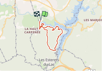
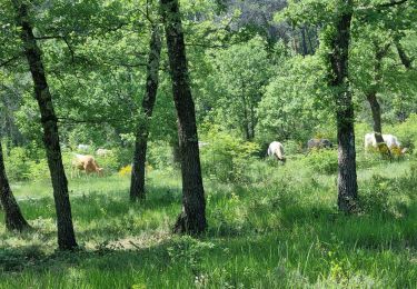
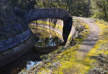
Randonnée Marche de 13,7 km à découvrir à Provence-Alpes-Côte d'Azur, Var, Montauroux. Cette randonnée est proposée par boulinevelyne.
Description
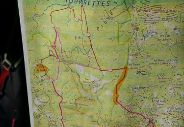
A partir du point 198 se rendre au point 301 puis aller à droite à la citerne. C'est plus long mais la côte sera moins raide.
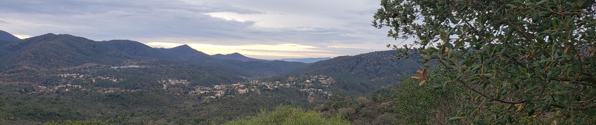
Prendre photo "Lac de Saint Cassien" pour la mettre sur le site R.A.
Localisation
Pays :
France
Région :
Provence-Alpes-Côte d'Azur
Département/Province :
Var
Commune :
Montauroux
Localité :
Unknown
Départ:(Dec)
Départ:(UTM)
320228 ; 4828561 (32T) N.
Commentaires
Randonnées à proximité
![Randonnée Marche Montauroux - CP FONDURANE - Photo](https://media.geolcdn.com/t/375/260/ext.jpg?maxdim=2&url=https%3A%2F%2Fstatic1.geolcdn.com%2Fsiteimages%2Fupload%2Ffiles%2F1553511878bg_sport_marche.png)
![Marche Marche](https://static1.geolcdn.com/sitytour/trail-icons/101.png)
CP FONDURANE
Marche
Facile
(1)
Montauroux,
Provence-Alpes-Côte d'Azur,
Var,
France
![](/images/other/stat-length.png)
7,9 km | 9,5 km-effort
1h 58min
![](https://static1.geolcdn.com/siteimages/upload/files/16400158638029165_repeat_loop_refresh_sync_direction_icon.png)
Oui
![Randonnée Marche Montauroux - Frankrijk - Lac de St. Cassien - Provence - Photo](https://media.geolcdn.com/t/375/260/ext.jpg?maxdim=2&url=https%3A%2F%2Fstatic1.geolcdn.com%2Fsiteimages%2Fupload%2Ffiles%2F1553511878bg_sport_marche.png)
![Marche Marche](https://static1.geolcdn.com/sitytour/trail-icons/101.png)
Frankrijk - Lac de St. Cassien - Provence
Marche
Très facile
(1)
Montauroux,
Provence-Alpes-Côte d'Azur,
Var,
France
![](/images/other/stat-length.png)
13,5 km | 18,7 km-effort
Inconnu
![](https://static1.geolcdn.com/siteimages/upload/files/16400158638029165_repeat_loop_refresh_sync_direction_icon.png)
Non
![Randonnée Marche Callian - Callian, ruines de Velnasque - Photo](https://media.geolcdn.com/t/375/260/f3797b20-4f1a-42d8-b8ed-35468ec43e4e.jpg&format=jpg&maxdim=2)
![Marche Marche](https://static1.geolcdn.com/sitytour/trail-icons/101.png)
Callian, ruines de Velnasque
Marche
Moyen
Callian,
Provence-Alpes-Côte d'Azur,
Var,
France
![](/images/other/stat-length.png)
13,7 km | 18,3 km-effort
6h 1min
![](https://static1.geolcdn.com/siteimages/upload/files/16400158638029165_repeat_loop_refresh_sync_direction_icon.png)
Non
![Randonnée Marche Tourrettes - Chêne chevelu et chêne crénelé - Photo](https://media.geolcdn.com/t/375/260/0647bcb0-53a2-4ab7-a8b3-01ff38e59da6.jpg&format=jpg&maxdim=2)
![Marche Marche](https://static1.geolcdn.com/sitytour/trail-icons/101.png)
Chêne chevelu et chêne crénelé
Marche
Moyen
Tourrettes,
Provence-Alpes-Côte d'Azur,
Var,
France
![](/images/other/stat-length.png)
7 km | 9,8 km-effort
2h 13min
![](https://static1.geolcdn.com/siteimages/upload/files/16400158638029165_repeat_loop_refresh_sync_direction_icon.png)
Oui
![Randonnée V.T.T. Tanneron - autour de tanneron - Photo](https://media.geolcdn.com/t/375/260/ext.jpg?maxdim=2&url=https%3A%2F%2Fstatic1.geolcdn.com%2Fsiteimages%2Fupload%2Ffiles%2F1524743154velo.jpg)
![V.T.T. V.T.T.](https://static1.geolcdn.com/sitytour/trail-icons/202.png)
autour de tanneron
V.T.T.
Très difficile
(1)
Tanneron,
Provence-Alpes-Côte d'Azur,
Var,
France
![](/images/other/stat-length.png)
30 km | 41 km-effort
2h 50min
![](https://static1.geolcdn.com/siteimages/upload/files/16400158638029165_repeat_loop_refresh_sync_direction_icon.png)
Oui
![Randonnée Marche Montauroux - z le bas défens à Montauroux 23-05-23 - Photo](https://media.geolcdn.com/t/375/260/6d791f12-dc8c-49b4-b31c-330901bd5d3d.jpg&format=jpg&maxdim=2)
![Marche Marche](https://static1.geolcdn.com/sitytour/trail-icons/101.png)
z le bas défens à Montauroux 23-05-23
Marche
Moyen
Montauroux,
Provence-Alpes-Côte d'Azur,
Var,
France
![](/images/other/stat-length.png)
5,3 km | 6,6 km-effort
2h 2min
![](https://static1.geolcdn.com/siteimages/upload/files/16400158638029165_repeat_loop_refresh_sync_direction_icon.png)
Oui
![Marche Marche](https://static1.geolcdn.com/sitytour/trail-icons/101.png)
Montauroux - Stade - Pont des Tuves - Chapelle St Saturnin - Dolmen - Ste Céz...
Marche
Moyen
Montauroux,
Provence-Alpes-Côte d'Azur,
Var,
France
![](/images/other/stat-length.png)
19 km | 29 km-effort
5h 12min
![](https://static1.geolcdn.com/siteimages/upload/files/16400158638029165_repeat_loop_refresh_sync_direction_icon.png)
Oui
![Randonnée Marche Callian - CCB Callian vallon de la Camiole - Photo](https://media.geolcdn.com/t/375/260/0ba06ee0-eb8d-42dd-88bd-dbcecdf40ad7.jpg&format=jpg&maxdim=2)
![Marche Marche](https://static1.geolcdn.com/sitytour/trail-icons/101.png)
CCB Callian vallon de la Camiole
Marche
Moyen
Callian,
Provence-Alpes-Côte d'Azur,
Var,
France
![](/images/other/stat-length.png)
14,3 km | 19,3 km-effort
9h 7min
![](https://static1.geolcdn.com/siteimages/upload/files/16400158638029165_repeat_loop_refresh_sync_direction_icon.png)
Oui
![Randonnée Marche Montauroux - St Cezaire : gorges de la Siagne - Photo](https://media.geolcdn.com/t/375/260/9e41473c-9f45-4eb9-a7e5-8d6de28f95c3.jpg&format=jpg&maxdim=2)
![Marche Marche](https://static1.geolcdn.com/sitytour/trail-icons/101.png)
St Cezaire : gorges de la Siagne
Marche
Très difficile
Montauroux,
Provence-Alpes-Côte d'Azur,
Var,
France
![](/images/other/stat-length.png)
20 km | 31 km-effort
7h 8min
![](https://static1.geolcdn.com/siteimages/upload/files/16400158638029165_repeat_loop_refresh_sync_direction_icon.png)
Oui