![](/images/other/stat-length.png)
![Randonnée Marche Fourons - Veurbos - Roodbos - Photo](https://media.geolcdn.com/t/1900/400/954e0552-84b3-47cf-9fcc-ecc48bbf6e54.jpg&format=pjpeg&maxdim=2)
Veurbos - Roodbos
mumu.larandonneuse
Utilisateur GUIDE
![Longueur](/images/other/stat-length.png)
Longueur
4,2 km
![Altitude max](https://static1.geolcdn.com/siteimages/upload/files/1508320355ic_sort_altitude_max_24dp.png)
Altitude max
270 m
![Dénivelé positif](https://static1.geolcdn.com/siteimages/upload/files/1508320355ic_sort_den_pos_24dp.png)
Dénivelé positif
75 m
![Km-Effort](/images/other/stat-length.png)
Km-Effort
5,2 km
![Altitude min](https://static1.geolcdn.com/siteimages/upload/files/1508320355ic_sort_altitude_min_24dp.png)
Altitude min
210 m
![Dénivelé négatif](https://static1.geolcdn.com/siteimages/upload/files/1508320355ic_sort_den_neg_24dp.png)
Dénivelé négatif
75 m
![Boucle](https://static1.geolcdn.com/siteimages/upload/files/16400158638029165_repeat_loop_refresh_sync_direction_icon.png)
Boucle
Oui
Date de création :
2023-12-13 10:25:57.622
Dernière modification :
2023-12-13 12:08:13.556
![Marche](https://static1.geolcdn.com/sitytour/trail-icons/101.png)
1h10
Difficulté : Facile
![Scannez ce code QR pour ouvrir la randonnée dans l'application SityTrail](https://capi.geolives.com/qq0zvz2zws4bq2lad0pu/sitytour/trails/3891973/qr.png?size=200)
Application GPS de randonnée GRATUITE
À propos
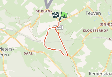
Randonnée Marche de 4,2 km à découvrir à Flandre, Limbourg, Fourons. Cette randonnée est proposée par mumu.larandonneuse.
Description
Une petite balade boisée pour récupérer les desserts glacés 🍧de Noël 🎄 🎅 à la ferme 't Voerboertje (distributeur automatique 24h/24).
📍Brasserie Het Rode Bos ( ouvert dès 11h00 et fermé lundi & mardi)
Passage par les points-noeuds 75 74 73.
Localisation
Pays :
Belgique
Région :
Flandre
Département/Province :
Limbourg
Commune :
Fourons
Localité :
Teuven
Départ:(Dec)
Départ:(UTM)
701461 ; 5625743 (31U) N.
Commentaires
Randonnées à proximité
![Randonnée Marche Plombières - Hombourg. Natura 2000, des sites qui valent le détour ! Lg6 - Photo](https://media.geolcdn.com/t/375/260/ext.jpg?maxdim=2&url=https%3A%2F%2Fservices.sitytrail.com%2FGeolivesWS%2FDownloadMedia.ashx%3FTrailID%3D142693%26Media%3D08dbd372-9409-44af-92fd-51b9576d1e78.JPG)
![Marche Marche](https://static1.geolcdn.com/sitytour/trail-icons/101.png)
Hombourg. Natura 2000, des sites qui valent le détour ! Lg6
Marche
Facile
(10)
Plombières,
Wallonie,
Liège,
Belgique
![](/images/other/stat-length.png)
9,5 km | 12 km-effort
2h 35min
![](https://static1.geolcdn.com/siteimages/upload/files/16400158638029165_repeat_loop_refresh_sync_direction_icon.png)
Oui
![Randonnée Marche Gulpen-Wittem - Epen _1518 - Photo](https://media.geolcdn.com/t/375/260/8521698d-6278-4db9-b85e-3d349e5101aa.jpg&format=jpg&maxdim=2)
![Marche Marche](https://static1.geolcdn.com/sitytour/trail-icons/101.png)
Epen _1518
Marche
Moyen
(1)
Gulpen-Wittem,
Limbourg,
Inconnu,
Pays-Bas
![](/images/other/stat-length.png)
6,6 km | 8,9 km-effort
2h 0min
![](https://static1.geolcdn.com/siteimages/upload/files/16400158638029165_repeat_loop_refresh_sync_direction_icon.png)
Oui
![Randonnée Marche Eijsden-Margraten - Mheer MH1 - Photo](https://media.geolcdn.com/t/375/260/1dd6d074-f00f-48cf-a4e6-d95117778ebf.jpg&format=jpg&maxdim=2)
![Marche Marche](https://static1.geolcdn.com/sitytour/trail-icons/101.png)
Mheer MH1
Marche
Moyen
(1)
Eijsden-Margraten,
Limbourg,
Inconnu,
Pays-Bas
![](/images/other/stat-length.png)
8,8 km | 11 km-effort
2h 29min
![](https://static1.geolcdn.com/siteimages/upload/files/16400158638029165_repeat_loop_refresh_sync_direction_icon.png)
Oui
![Randonnée Marche Eijsden-Margraten - Mheer - Banholt - Hoogbos - Photo](https://media.geolcdn.com/t/375/260/1f70cdf1-9a0b-4d25-acc7-7c75993bbb86.jpg&format=jpg&maxdim=2)
![Marche Marche](https://static1.geolcdn.com/sitytour/trail-icons/101.png)
Mheer - Banholt - Hoogbos
Marche
Moyen
(1)
Eijsden-Margraten,
Limbourg,
Inconnu,
Pays-Bas
![](/images/other/stat-length.png)
12,5 km | 14,5 km-effort
3h 4min
![](https://static1.geolcdn.com/siteimages/upload/files/16400158638029165_repeat_loop_refresh_sync_direction_icon.png)
Oui
![Randonnée Marche Fourons - Amstel Gold Race 2024 🚲 - Photo](https://media.geolcdn.com/t/375/260/bca146f7-0c03-4970-a3ca-ea328283e994.jpg&format=jpg&maxdim=2)
![Marche Marche](https://static1.geolcdn.com/sitytour/trail-icons/101.png)
Amstel Gold Race 2024 🚲
Marche
Moyen
(1)
Fourons,
Flandre,
Limbourg,
Belgique
![](/images/other/stat-length.png)
11,7 km | 14,9 km-effort
3h 23min
![](https://static1.geolcdn.com/siteimages/upload/files/16400158638029165_repeat_loop_refresh_sync_direction_icon.png)
Oui
![Randonnée Marche Gulpen-Wittem - Epen - Vijlen - Mechelen - Photo](https://media.geolcdn.com/t/375/260/5bb62a81-94e0-4aeb-8671-819fde7ee6b3.jpg&format=jpg&maxdim=2)
![Marche Marche](https://static1.geolcdn.com/sitytour/trail-icons/101.png)
Epen - Vijlen - Mechelen
Marche
Facile
(1)
Gulpen-Wittem,
Limbourg,
Inconnu,
Pays-Bas
![](/images/other/stat-length.png)
13,9 km | 17,5 km-effort
3h 9min
![](https://static1.geolcdn.com/siteimages/upload/files/16400158638029165_repeat_loop_refresh_sync_direction_icon.png)
Oui
![Randonnée Marche Fourons - Ulvend - La Planck - Noorbeek - Photo](https://media.geolcdn.com/t/375/260/1b8a3af4-c436-4943-b8e2-3197209c6144.jpg&format=jpg&maxdim=2)
![Marche Marche](https://static1.geolcdn.com/sitytour/trail-icons/101.png)
Ulvend - La Planck - Noorbeek
Marche
Facile
(1)
Fourons,
Flandre,
Limbourg,
Belgique
![](/images/other/stat-length.png)
17 km | 22 km-effort
4h 57min
![](https://static1.geolcdn.com/siteimages/upload/files/16400158638029165_repeat_loop_refresh_sync_direction_icon.png)
Oui
![Randonnée Marche Fourons - Wandelroute-de-voerstreek-mooiste - Photo](https://media.geolcdn.com/t/375/260/3df743f8-88e4-4c10-a47a-c05fdf0072fe.jpg&format=jpg&maxdim=2)
![Marche Marche](https://static1.geolcdn.com/sitytour/trail-icons/101.png)
Wandelroute-de-voerstreek-mooiste
Marche
Moyen
(1)
Fourons,
Flandre,
Limbourg,
Belgique
![](/images/other/stat-length.png)
9,3 km | 12,5 km-effort
2h 49min
![](https://static1.geolcdn.com/siteimages/upload/files/16400158638029165_repeat_loop_refresh_sync_direction_icon.png)
Oui
![Randonnée Marche Fourons - La Commanderie 7 - Photo](https://media.geolcdn.com/t/375/260/e2b67305-0779-4cca-9070-82e3402cc790.jpg&format=jpg&maxdim=2)
![Marche Marche](https://static1.geolcdn.com/sitytour/trail-icons/101.png)
La Commanderie 7
Marche
Facile
(1)
Fourons,
Flandre,
Limbourg,
Belgique
![](/images/other/stat-length.png)
4,5 km | 6,3 km-effort
1h 26min
![](https://static1.geolcdn.com/siteimages/upload/files/16400158638029165_repeat_loop_refresh_sync_direction_icon.png)
Oui