Randonnée  Longchaumois - Les écureuils - Photo
© OpenStreetMap contributors
Longueur
Longueur
4,2 km
Altitude max
Altitude max
1165 m
Dénivelé positif
Dénivelé positif
82 m
Km-Effort
Km-Effort  
5,3 km
Altitude min
Altitude min
1108 m
Dénivelé négatif
Dénivelé négatif
82 m
Boucle
Boucle
Oui
Date de création :
2023-12-07 08:50:43.0
Dernière modification :
2023-12-07 11:23:45.617

(0 Avis)


Scannez ce code QR pour ouvrir la randonnée dans l'application SityTrail

Application GPS de randonnée GRATUITE

Logo SityTrail SityTrail

IGN / Instituts géographiques

Télécharger SityTrail sur l'App Store Télécharger SityTrail sur Google Play

Logo SityTrail SityTrail World

Le monde est à vous

Télécharger SityTrail sur l'App Store Télécharger SityTrail sur Google Play Télécharger SityTrail sur Huawei AppGallery

À propos

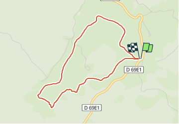
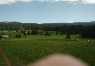
Randonnée de 4,2 km à découvrir à Bourgogne-Franche-Comté, Jura, Longchaumois. Cette randonnée est proposée par 001749.0ab22087601e44fe9b6f41e5b885e59e.1227.

Profil altimétrique

Localisation

Pays :
France
Région :
Bourgogne-Franche-Comté
Département/Province :
Jura
Commune :
Longchaumois
Localité :
Unknown
Départ:(Dec)
Départ:(UTM)
728549 ; 5147516 (31T) N.

Randonnées à proximité

Randonnée Vélo  - Lac de Lamoura et Valserine - Prémanon - Photo
Vélo
tracegps

Vélo

Moyen
(1)
, Bourgogne-Franche-Comté, Jura, France
39 km | 49 km-effort
2h 0min
Oui
Randonnée Marche  - Le Belvédère des Maquisards - Prémanon - Photo
Marche
tracegps

Marche

Moyen
(1)
, Bourgogne-Franche-Comté, Jura, France
5,4 km | 7,8 km-effort
2h 0min
Oui
Randonnée Marche  - Autour de Prémanon - Photo
Marche
tracegps

Marche

Très difficile
(1)
, Bourgogne-Franche-Comté, Jura, France
18 km | 27 km-effort
6h 0min
Oui
Randonnée A pied  - Les Arcets - Photo
A pied
GUIDE+

A pied

Facile
, Bourgogne-Franche-Comté, Jura, France
9 km | 13,6 km-effort
3h 5min
Oui
Randonnée Marche  - Prémanon, Mont Fier  - Photo
Marche
MoiClaude

Marche

Très facile
(1)
, Bourgogne-Franche-Comté, Jura, France
10,9 km | 15,8 km-effort
2h 34min
Non
Randonnée Raquettes à neige Lamoura - Lamoura le massacre 8/2/2020 - Photo
Raquettes à neige
barmi

Raquettes à neige

Très facile
(1)
Lamoura, Bourgogne-Franche-Comté, Jura, France
12,6 km | 17,1 km-effort
4h 8min
Oui
Randonnée Marche Lamoura - Jura 07-06-2019 - Photo
Marche
jesusmarieclaire

Marche

Très facile
Lamoura, Bourgogne-Franche-Comté, Jura, France
6 km | 8,3 km-effort
2h 23min
Oui
Randonnée Marche Lamoura - Jura 1(02-06-19) - Photo
Marche
jesusmarieclaire

Marche

Très facile
Lamoura, Bourgogne-Franche-Comté, Jura, France
5,6 km | 7,7 km-effort
2h 55min
Oui
Randonnée V.T.T.  - Tour des Cressonnières en VTT - Prémanon - Photo
V.T.T.
tracegps

V.T.T.

Difficile
, Bourgogne-Franche-Comté, Jura, France
8 km | 10,8 km-effort
1h 0min
Oui


Fermer
Mes abonnements