![](/images/other/stat-length.png)
![Randonnée Marche Stavelot - Extratrail_stavelot_13km - Photo](https://media.geolcdn.com/t/1900/400/7e0cb8b0-296a-4a03-9e12-90eb5ad4d1fc.jpeg&format=pjpeg&maxdim=2)
Extratrail_stavelot_13km
Efr
Utilisateur
![Longueur](/images/other/stat-length.png)
Longueur
13,4 km
![Altitude max](https://static1.geolcdn.com/siteimages/upload/files/1508320355ic_sort_altitude_max_24dp.png)
Altitude max
510 m
![Dénivelé positif](https://static1.geolcdn.com/siteimages/upload/files/1508320355ic_sort_den_pos_24dp.png)
Dénivelé positif
477 m
![Km-Effort](/images/other/stat-length.png)
Km-Effort
19,8 km
![Altitude min](https://static1.geolcdn.com/siteimages/upload/files/1508320355ic_sort_altitude_min_24dp.png)
Altitude min
281 m
![Dénivelé négatif](https://static1.geolcdn.com/siteimages/upload/files/1508320355ic_sort_den_neg_24dp.png)
Dénivelé négatif
477 m
![Boucle](https://static1.geolcdn.com/siteimages/upload/files/16400158638029165_repeat_loop_refresh_sync_direction_icon.png)
Boucle
Oui
Date de création :
2023-12-06 22:03:49.286
Dernière modification :
2023-12-06 22:10:32.09
![Marche](https://static1.geolcdn.com/sitytour/trail-icons/101.png)
4h29
Difficulté : Très difficile
![Scannez ce code QR pour ouvrir la randonnée dans l'application SityTrail](https://capi.geolives.com/qq0zvz2zws4bq2lad0pu/sitytour/trails/3886647/qr.png?size=200)
Application GPS de randonnée GRATUITE
À propos
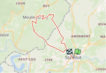
Randonnée Marche de 13,4 km à découvrir à Wallonie, Liège, Stavelot. Cette randonnée est proposée par Efr.
Description
Parcours bleu
Distance 13,5 km
Dénivelé 478 m
Durée 1h30 à 2h30
Difficulté
Départ :
Office du Tourisme (Cour de l'Abbaye 1 - 4970 Stavelot)
Localisation
Pays :
Belgique
Région :
Wallonie
Département/Province :
Liège
Commune :
Stavelot
Localité :
Unknown
Départ:(Dec)
Départ:(UTM)
708379 ; 5586513 (31U) N.
Commentaires
Randonnées à proximité
![Randonnée Marche Trois-Ponts - RB-Lg-29_Wanne - Photo](https://media.geolcdn.com/t/375/260/ext.jpg?maxdim=2&url=https%3A%2F%2Fservices.sitytrail.com%2FGeolivesWS%2FDownloadMedia.ashx%3FTrailID%3D402097%26Media%3Dd4589c74-2522-4a62-866b-b5d0038bf075.jpg)
![Marche Marche](https://static1.geolcdn.com/sitytour/trail-icons/101.png)
![Randonnée Marche Trois-Ponts - RB-Lg-27_Trois-Ponts - Photo](https://media.geolcdn.com/t/375/260/ext.jpg?maxdim=2&url=https%3A%2F%2Fservices.sitytrail.com%2FGeolivesWS%2FDownloadMedia.ashx%3FTrailID%3D402090%26Media%3Ddb9e80d9-8efc-4045-abb6-cee4f6885ea2.jpg)
![Marche Marche](https://static1.geolcdn.com/sitytour/trail-icons/101.png)
RB-Lg-27_Trois-Ponts
Marche
(7)
Trois-Ponts,
Wallonie,
Liège,
Belgique
![](/images/other/stat-length.png)
23 km | 33 km-effort
7h 30min
![](https://static1.geolcdn.com/siteimages/upload/files/16400158638029165_repeat_loop_refresh_sync_direction_icon.png)
Oui
![Randonnée Marche Stavelot - Extratrail_stavelot_13km_new - Photo](https://media.geolcdn.com/t/375/260/acb4a21b-3ac7-4958-9a44-c1358ae78040.jpg&format=jpg&maxdim=2)
![Marche Marche](https://static1.geolcdn.com/sitytour/trail-icons/101.png)
Extratrail_stavelot_13km_new
Marche
Moyen
(2)
Stavelot,
Wallonie,
Liège,
Belgique
![](/images/other/stat-length.png)
13,4 km | 19,8 km-effort
4h 30min
![](https://static1.geolcdn.com/siteimages/upload/files/16400158638029165_repeat_loop_refresh_sync_direction_icon.png)
Oui
![Randonnée Marche Stavelot - Stavelot - Photo](https://media.geolcdn.com/t/375/260/8b34c446-55a9-478c-88d7-9cb986b390fb.jpg&format=jpg&maxdim=2)
![Marche Marche](https://static1.geolcdn.com/sitytour/trail-icons/101.png)
Stavelot
Marche
Difficile
(3)
Stavelot,
Wallonie,
Liège,
Belgique
![](/images/other/stat-length.png)
18,8 km | 26 km-effort
5h 53min
![](https://static1.geolcdn.com/siteimages/upload/files/16400158638029165_repeat_loop_refresh_sync_direction_icon.png)
Non
![Randonnée Marche Trois-Ponts - RB-Lg-27_Trois-Ponts_via-racc - Photo](https://media.geolcdn.com/t/375/260/ext.jpg?maxdim=2&url=https%3A%2F%2Fservices.sitytrail.com%2FGeolivesWS%2FDownloadMedia.ashx%3FTrailID%3D402091%26Media%3Ddb9e80d9-8efc-4045-abb6-cee4f6885ea2.jpg)
![Marche Marche](https://static1.geolcdn.com/sitytour/trail-icons/101.png)
RB-Lg-27_Trois-Ponts_via-racc
Marche
Très difficile
(1)
Trois-Ponts,
Wallonie,
Liège,
Belgique
![](/images/other/stat-length.png)
16,9 km | 25 km-effort
5h 36min
![](https://static1.geolcdn.com/siteimages/upload/files/16400158638029165_repeat_loop_refresh_sync_direction_icon.png)
Oui
![Randonnée Marche Stavelot - Chemin des Sources |étape n°3 STAVELOT – HOCKAI - Photo](https://media.geolcdn.com/t/375/260/77791607-24fa-4b91-a259-1d28dbfa8616.jpg&format=jpg&maxdim=2)
![Marche Marche](https://static1.geolcdn.com/sitytour/trail-icons/101.png)
Chemin des Sources |étape n°3 STAVELOT – HOCKAI
Marche
Très difficile
(1)
Stavelot,
Wallonie,
Liège,
Belgique
![](/images/other/stat-length.png)
19 km | 25 km-effort
5h 45min
![](https://static1.geolcdn.com/siteimages/upload/files/16400158638029165_repeat_loop_refresh_sync_direction_icon.png)
Non
![Randonnée Trail Stavelot - Extra Trail - Stavelot (rouge) 23km - Photo](https://media.geolcdn.com/t/375/260/e53e9997-9f75-44d1-82da-8b0ea05ce39d.jpg&format=jpg&maxdim=2)
![Trail Trail](https://static1.geolcdn.com/sitytour/trail-icons/104.png)
Extra Trail - Stavelot (rouge) 23km
Trail
Très difficile
(1)
Stavelot,
Wallonie,
Liège,
Belgique
![](/images/other/stat-length.png)
23 km | 35 km-effort
Inconnu
![](https://static1.geolcdn.com/siteimages/upload/files/16400158638029165_repeat_loop_refresh_sync_direction_icon.png)
Oui
![Randonnée Trail Stavelot - Extra Trail - Stavelot (bleu) 13km - Photo](https://media.geolcdn.com/t/375/260/5430f923-8847-4982-8f77-551b984d4068.jpg&format=jpg&maxdim=2)
![Trail Trail](https://static1.geolcdn.com/sitytour/trail-icons/104.png)
Extra Trail - Stavelot (bleu) 13km
Trail
Difficile
(1)
Stavelot,
Wallonie,
Liège,
Belgique
![](/images/other/stat-length.png)
13,4 km | 19,5 km-effort
Inconnu
![](https://static1.geolcdn.com/siteimages/upload/files/16400158638029165_repeat_loop_refresh_sync_direction_icon.png)
Oui
![Randonnée Trail Stavelot - Extratrail - Stavelot (vert) 9km - Photo](https://media.geolcdn.com/t/375/260/9bfee553-8e48-41c4-b7d0-2265cc8c3fde.jpg&format=jpg&maxdim=2)
![Trail Trail](https://static1.geolcdn.com/sitytour/trail-icons/104.png)
Extratrail - Stavelot (vert) 9km
Trail
Moyen
(1)
Stavelot,
Wallonie,
Liège,
Belgique
![](/images/other/stat-length.png)
10,1 km | 13,9 km-effort
Inconnu
![](https://static1.geolcdn.com/siteimages/upload/files/16400158638029165_repeat_loop_refresh_sync_direction_icon.png)
Oui